 |
Sunshine Highway Relic Run
Tuesday, 23 July 2024 |
|
")
What is the Sunshine Highway Relic Run?
In the early 1920s, the highways of Manitoba were primitive but automobile enthusiastis nevertheless wanted to get out and see the province. With encouragement from Arthur Coates “Ace” Emmett of the Manitoba Motor League (today's CAA Manitoba), they developed motoring routes. One of those routes, the Sunshine Highway starting in Brandon, connected to a route in the United States that ended in Sioux City, Iowa.
More information on the Sunshine Highway, compiled by historian Ken Storie.
Jump forward to 23 July 2024. A group of antique automobiles, all made in 1938 or earlier, drove the historic Sunshine Highway from the Canada-US border south of Crystal City to Brandon. This 120-mile (190-kilometre) drive took the better part of a day and involved stops in Crystal City, Rock Lake, Glenora, Baldur, Glenboro, Wawanesa, and Brandon.
Vehicle Registration
The following 16 vehicles participated in the Relic Run:
Make and Model |
Drivers and passengers |
1920 Overland Model 4 |
Murray and Linda Johanson |
1922 Ford Model T |
Roland Desrochers |
1923 Ford Model T Touring |
Allen Peters |
1923 Ford Model T-Bucket |
Don Funk |
1924 Dodge Brothers Business Coupe |
Bryan and Fran Jackson |
1926 Hudson Brougham Sedan |
Brent and Dale Checkley |
1926 Ford Model TT Truck |
Richard Wileman |
1927 Ford Model T Touring |
David Rourke |
1928 Ford Model A Depot Hack |
Charlie Baldock |
1928 Ford Model A Tudor |
Kane Gervin |
1929 Pontiac |
Larry Gross |
1930 Nash |
Ken Gardiner |
1931 Ford Model A Four-Door |
Carman and Pat Tufts |
1931 Ford Model A Victoria |
John and Stella Olver |
1934 Chevy Coupe |
Barry Barylski |
1938 Pontiac Coupe |
Ike Reimer |
Route & Itinerary (mostly unpaved)

A = Canada-US border
B = Crystal City
C = Rock Lake |
D = Glenora
E = Baldur
F = Glenboro |
G = Wawanesa
H = Rounthwaite
I = Brandon |
The itinerary was based on an assumed speed of 25 miles per hour (40 kilometres per hour).
Photos (click to enlarge)
Frequently Asked Questions
Q: How do I know that I am on the Sunshine Highway?
A: The route of the original Sunshine Highway was marked by large yellow signs marked with the letter S.
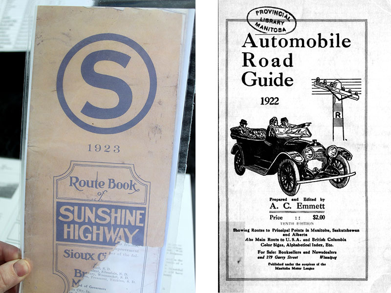
Q: How do we know the original route of the Sunshine Highway?
A: In the 1920s, the Sunshine Highway organization and the Manitoba Motor League published guides (photos below) showing the route of the Sunshine Highway. We are using those guides to reconstruct the route on today's roads.
Q: Why are you driving at 25 miles per hour?
A: The oldest cars in the Relic Run are over 100 years old and, as such, their maximum speed determines the pace of the Relic Run.
Q: Is the Sunshine Highway route all paved?
A: No. Most of the route is gravel.
Contact Us
Contact the organizers of the Sunshine Highway Relic Run at sunshinehighway1921@gmail.com.
Back to top of page
Sunshine Highway Relic Run 2024
| 


