Manitoba Pageant, Spring 1971, Volume 16, Number 3
|
On April 16, 1739, while encamped at his newly constructed Fort La Reine, near the site of Portage la Prairie, La Verendrye wrote in his journal: "I sent my [youngest] son the Chevalier [Louis-Joseph] this morning, in company with a savage, to go and explore the region ... of Lake Winnipeg ... and examine the rivers that flow into the lake ... and also the mine on the lake." [1]
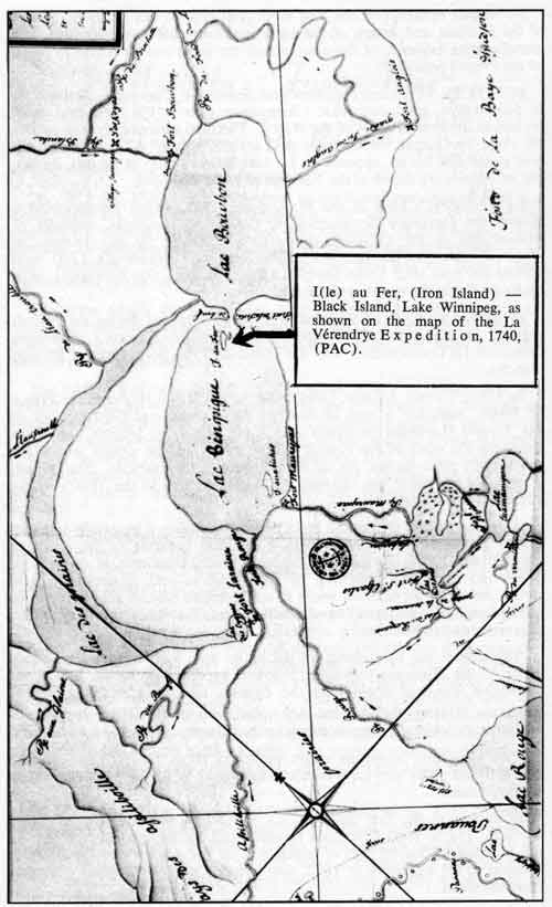
The mine which the twenty-one year old Louis-Joseph was sent to investigate was the deposit of hematite or red iron ore located at Red Rock, on the southeast shore of Black Island, some five miles from the western tip of the island.
The natives had been telling La Verendrye stories of mines since the earliest days of his western exploration. In his 1729 report to Marquis de Beauharnois, Governor of New France, La Verendrye spoke of the Indians "who live towards the outlet of the Lake of the Woods, where the great river of the West [Winnipeg] has its beginning. It is in the lands to the left of the great river as you follow it down that minerals and metals are found in quantity. Among the metals, they are acquainted with lead and copper."
These Indians were doubtless repeating tales that had reached them from their cousins to the south, for Pierre Charles Le Seur had reported in 1693 the discovery of lead mines on the Upper Mississippi and copper in the same region in 1700.
Later, in one of his subsequent memoirs to Beauharnois from Fort St. Charles, Lake of the Woods, La Verendrye stated: "These savages told me they knew of several iron mines of different colors; that there was one five day's journey from Fort St. Charles, the iron of which is pure and difficult to break, black on the surface and white inside, [possibly magnetite]; another further away, the iron of which is in large lumps and was used by them for making bracelets [2] [probably the Red Rock deposit]. The other was near a great river to the West [Saskatchewan?], the ore of which is yellow and hard [possibly iron pyrite], and that through the middle of this yellow iron deposit there runs a stream which leaves a sand of the same color on the bottom."
In 1734 two of La Verendrye's men had paddled up Lake Winnipeg as far as Detroit de la Tete-de-Boeuf [Bull's Head Strait] at the narrows of the lake just north of Black Island. Champagne [3] suggests that the purpose of this trip may have been to make a preliminary search for the red iron ore, as there appears to have been no need for the construction of a fort in this locality.
No further reference to the Red Rock iron deposit can be found in any of the journals and letters of the La Verendryes that have survived, but corroborative evidence of the existence of the mine can be found in maps of the French period.
In 1735 La Verendrye's nephew and lieutenant, Christophe Dufrost de la Jemmeraye, produced what Champagne calls: "The first and most perfect of the French maps of the West." [4] The final cartography was probably done by Gaspar Chaussegros de Lery in October 1733. The island, now called Elk Island, appears on La Jemmeraye's map at Ile aux Biches, but no islands are shown at the Narrows of Lake Winnipeg.
La Verendrye's Map of the West, dated 1737, which accompanied a letter from Governor Beauharnois to Comte de Maurepas, Minister of Marine and of the Colonies, shows in addition to Ile aux Biches, an unnamed island at the narrows of the lake. La Verendrye's 1740 map (made the year after Louis-Joseph's expedition on Lake Winnipeg) plots an Ile au Fer at the narrows of the lake.
Ile au Fer is shown on all subsequent maps prepared during the French regime, including the 1749 map drawn for Beauharnois's successor, Governor La Galissonniere, and the elaborate 1754 production of Phillipe Buache.
In 1762, Thomas Jefferys, Geographer to His Royal Highness the Prince of Wales, published a map to illustrate his Natural and Civil History of the French Dominion in North and South America. Jefferys' map was based on the work of the French cartographers and he simply Anglicized the French place names, Ile au Fer becoming, for example, Iron Island. Eventually the name was changed to Big Island and in the 1880s to the present Black Island.
A unique feature of the Red Rock ore which makes it especially interesting to geologists and mineralogists is that the hematite is the result of surficial weathering during Precambrian times. Hundreds of millions of years ago a deposit consisting of both massive and disseminated iron pyrite, occurring in silicified zones in soft greenish sericite schist, began to oxidize gradually to form limonite which later, through the loss of water, was converted to hematite. [5]
Throughout the Palaeozoic era the entire area was under water. Sandstone of the Winnipeg formation followed by dolomite of the Red River formation was laid down over the deposit, effectively stopping further oxidation. During the last Ice Age, glaciation removed the capping of sedimentary rocks, once again exposing the hematite.
Two significant questions might be asked about the red iron ore on Black Island. Why was La Verendrye interested in it? Of what use was it to the Indians?
In answer to the first question, La Verendrye was a native of Trois Rivieres, and he must have been familiar with the deposits of bog iron in the St. Maurice valley, part of which was on the seignory of La Gabelle, granted to his ancestors in 1672, and situated a short distance upstream from the town.
These mines were known as early as 1670, and one of the most progressive of the Intendants ever sent out from France, Talon, shipped twenty barrels of ore to France where tests showed that an iron, very low in impurities, and comparable to the best Swedish iron, could be produced from the St. Maurice veins. However, Versailles stubbornly refused for years to grant permission for the establishment of a local blast furnace, claiming that the colonies should not be allowed to produce finished iron in competition with home industry. Finally, in 1729, Louis XV relented and granted Poulin de Francheville the right to build the St. Maurice Forges and, in addition, awarded him a subsidy of 10,000 livres. [6]
La Verendrye realized that the discovery of ores of the base metals - iron, copper or lead; and in particular, of the precious metals - gold and silver (in which His Majesty held regalian rights), would be looked on with favor by the Crown and might result in an increase in the financial backing he sorely needed to carry on the exploration of the West. He therefore attempted to report on and examine any mines he was told about by the natives, but he lacked the manpower to undertake prospecting on his own.
In answer to the second question: Of what use was the red iron ore on Black Island to the Indians? It was certainly for some purpose other than the production of metallic iron. According to T. A. Rickard, [7] the recognized authority on the history of American mining, none of the Indian tribes of North America had acquired even the slightest knowledge of the science of metallurgy. This is corroborated by Jenness [8] who said of the Canadian Indian culture: "Many tribes made tools and ornaments of native copper; but since they treated it simply as a malleable stone and possessed no knowledge of smelting, they were still far removed from a true metal age."
Although they did not know how to utilize the Red Rock hematite to manufacture iron, the deposit was valuable to the Indians as a source of war-paint for the men and rouge for the women. In his Travels and Adventures, Alexander Henry [the elder] made some interesting comments on the use of vermilion or red ochre [hematite] by the aborigines. Of the Crees he met at the mouth of Winnipeg River, he said: "The women, like the men, paint their faces with red ochre and in addition, usually tattoo two lines reaching from the lip to the chin or from the corners of the mouth to the ears. They omit nothing to make themselves lovely. The men were almost entirely naked and painted their bodies with red ochre ... often called vermilion."
Henry went on to make the curious assertion: "They [Indians] procured [red ochre] in the mountains." One can only assume that the Indians, for very good reasons of their own, deliberately falsified the information they gave Henry as to the origin of their ochre or that they were referring to the high sandstone cliffs overlying the Red Rock deposit as mountains. Henry himself had some queer ideas as to the size of mountains, for he said that the rock formations along the Winnipeg River near Pinawa were mountainous.
The Red Rock ore body is the sole occurrence of hematite listed in the authoritative Geology and Mineral Resources of Manitoba, published by the Department of Mines and Natural Resources. It was the only place within a reasonable distance where the Indians could quarry the raw material they needed for cosmetics. To prepare the crude rouge, they crushed and pulverized chunks of red iron oxide with stone clubs.
When making up his consignment of trade goods in April 1738, La Verendrye bought from the Magasin du Roi in Quebec, ten pounds of Vermilion for barter to the Indians. The vermilion, imported from France, cost him 55 livres. In 1752, Saint Pierre, La Verendrye's successor, shipped three pounds of vermilion to the outpost at Bull's Head. [9] Apparently the Indians preferred the fine French rouge to their own coarse local product.
For nearly a century and a half after young La Verendrye's examination of Red Rock, the white man did nothing to develop and exploit the mine. At what date in the modern era prospectors first staked the iron ore deposits on Black Island is difficult to determine because the files of the original recordings are no longer available.
1. Journals and Letters of Pierre Gaultier de Varennes de la Verendrye and his sons, Champlain Society, L. J. Burpee, (Toronto, 1927), p. 357.
2. The Indians did not know how to smelt or reduce the iron ore to the metallic form but probably made bracelets by stringing small pieces of hematite on animal sinews or plant roots.
3. Personal communication, Reverend Antoine Champagne to the author, October 8, 1970.
4. Les La Verendrye et le Poste de l'Ouest, Antoine Champagne, C.R.I.C., (Quebec, 1968), p. 136, n. 9.
5. The Hematite on Black Island, G. M. Brownell and A. E. Kliske, Transactions, C.I.M.M., 1945, p. 291.
6. Encyclopedia Canadiana, v. 9, (Ottawa, 1962), p. 182.
7. A History of American Mining, T. A. Rickard, (New York, 1932), p. 1.
8. Indians of Canada, Diamond Jenness, (Ottawa, 1955), 3rd edition, p. 33.
9. Travels and Adventures - 1760-66, Alexander Henry, (New York, 1807), ed. by M. M. Quaife, (Chicago, 1921), p. 239 et seq.
George F. Reynolds, Winnipeg, a retired mining engineer, has a summer home at the pioneer lumbering settlement of Manigotogan on the east shore of Lake Winnipeg opposite Black Island.
The foregoing article is the introductory portion of a paper on the Black Island iron and the Red Rock deposit. In subsequent chapters, Mr. Reynolds traces the course of staking, surveying, and drilling; professional reports, registration of claims, and periodic but fruitless operations to bring the deposit into commercial production in the 19th and 20th centuries.
Mr. Reynolds concludes as follows: “The central block of claims was abandoned in July 1949, and on February 28, 1963, the two original Proudfoot locations reverted to the Crown under the provisions of the Mining Royalty and Tax Act, thus bringing to a close the history of the deposit of red iron ore which had first been seen by Louis-Joseph La Verendrye in 1739, some 224 years before. The Government of Manitoba has proposed establishing a Wilderness Park on Black Island, Hecla and adjacent islands, and the iron formations will undoubtedly be withdrawn permanently from staking. It is to be hoped that a cairn will be erected to mark the site of Manitoba's first mine.”
Page revised: 19 July 2009