Number 37, Spring / Summer 1999
|
Written in 1967, this memoir by William Harold Hunt recounts the author’s exploits as a surveyor over half a century earlier on the planned route of the Hudson Bay Railway in Manitoba. Born in 1884 near Lennoxville, in the eastern townships of Quebec, William Hunt arrived in Manitoba with his parents in 1901. Educated at Wesley College and the University of Manitoba, he financed his training as a civil engineer through survey work on the planned route of the rail line to Hudson Bay. After graduating in 1913 he was employed as an engineer by the City of Moose Jaw and in 1916 was appointed Assistant Engineer to the Good Roads Board of Manitoba, becoming District Engineer for the Board the following year. He held this position until 1940 and helped locate and design the first number one highway between Winnipeg and the Ontario border. In 1940 he enlisted with the Winnipeg Rifles and the following year was transferred to the Royal Canadian Engineers where he served until 1945. In 1950 Hunt was appointed supervising engineer for the federal government in connection with the construction of the Trans-Canada Highway in Saskatchewan. With the completion of that project in 1954 he returned to private practice and died in Winnipeg in January of 1976. W. H. Hunt’s memoir of life on the Hudson Bay Railway Survey was edited for publication by his son, John David Hunt of White Rock, British Columbia. Photographs accompanying this memoir were supplied by William Hunt’s daughter Margaret Carter of Winnipeg.
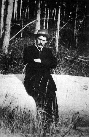
W. H. Hunt, circa 1910.
Source: Margaret Carter
A rumour circulating in the engineering students drafting room on the top floor of the old University of Manitoba building on Broadway Avenue in the city of Winnipeg, late in April of 1910, prompted me to call on John Armstrong, chief engineer of the Hudson Bay Railway. His office at that time was in the basement of Fort Garry Court, at the corner of Broadway and Main Street.
Mr. Armstrong seemed favourably inclined towards employing engineering students, particularly one like myself who had some experience on surveys for railways with the Grand Trunk Pacific Railway branch lines between Biggar and Battleford, and between Young and Prince Albert. In accordance with his suggestion, I called at his office one week later and was informed there was a vacancy for one rodman on location engineer F. P. Moffatt’s party. Unlike other students who had applied, I was willing to remain on the party during the following winter. I needed all that I could earn during that period to pay my expenses as a third-year student. I forthwith began to collect my kit for use in the months ahead.
On May 21st, personnel to make up the two parties was assembled in Winnipeg. One party was headed by location engineer Peter Gordon, afterwards the Gordon of Sherritt-Gordon mining fame. The other party, to which I was attached, was in the charge of location engineer F. P. Moffatt, who like Gordon, had been previously employed on location and construction on the Transcontinental in northern Ontario and western Quebec. Our instructions were to take the Winnipeg Selkirk Electric Street Railway to the town of Selkirk, and from there to proceed northwards on Lake Winnipeg to Norway House, from which point we were to proceed by canoe and York boat down the Nelson River to Manitoba Rapids, where work was to commence. F. P. Moffatt was to work south towards Thicket Portage, with Pete Gordon running the proposed line from Manitou Rapids to Port Nelson. Subsequently, F. P. Moffatt’s party worked on a trial line run by location engineer W. J. Clifford between Thicket Portage and Fort Churchill. On the 27th of May the good ship City of Selkirk took on a load of lumber, a supply of cordwood for the steam boilers, about ten fishermen on their way out to their fishing fields at the north end of the Lake, besides the two survey parties consisting of about 24 men, including eight canoes.
As we passed settlements along the Red River our passengers, at least a dozen of whom came from St. Peter’s Indian Reserve, waved farewell to their friends and family ashore. L.] For the first few miles north of the mouth of the Red, the lake was quite rough, but the waves calmed down after the boat reached deeper water. We stopped at Gull Harbour to unload the lumber and drop off a few of the fishermen. Most stayed aboard until Berens Landing.
On the morning of the 29th of May, our boat arrived at Warren’s Landing. There we unloaded our canoes and other equipment onto a barge and a small tugboat which towed us through the shallower water between Warren’s Landing and Norway House. At Norway House, both parties set up their tents on the shore immediately south of the Hudson’s Bay Post. Just south of our camping ground stood two tents occupied by a Dominion Government forestry representative whose duty it was to make a survey of the timber resources of the North Land. The chief of this party was J. P. Dickson, who was experiencing trouble with his camp cook. The cook was endeavouring to run the party. After leaving Norway House, we never saw the forestry men again, but at Thicket Portage, later in the fall, we did see stumps of trees sawn off by this outfit to enable the men to count the yearly growth rings.
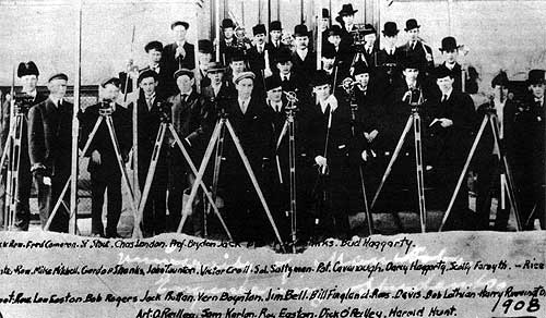
Civil engineering class, University of Manitoba, 1908. W. H. Hunt is at extreme right, front row.
Source: Margaret Carter
On the day following our arrival at Norway House, a Sunday, four of us attended divine service at the Methodist mission house at Rossville, about one mile north of the Hudson’s Bay company store. Our group included: Joe Irving, afterwards city engineer for Ottawa; Russell Lesley, afterwards Dr. W. R. Lesley of Morden Experimental Station, Frank Rutherford afterwards superintendent of construction for Fraser Construction Company of Montreal, and the writer, The service was conducted in Cree, the hymns and bibles were all written in Cree syllabics, so the boys from the survey party had difficulty in following the service. During that Sabbath day and the evening the survey boys from St. Peter’s were well entertained by the young native girls who had arrived at the post with the canoemen who were to act as our guides through the rapids of the Nelson River.
Inside the wooden fence that surrounded the company buildings stood a sun dial, said to have been placed there by Sir John Franklin on his way northwards on an exploration journey from which he never returned. Another point of interest we noted was a monument erected near the Post in memory of two Hudson’s Bay men who lost their lives in a canoe accident in a rapid not far from the post, a rapid we ourselves later had to negotiate. The victims were Horace Belanger, Chief Factor, and Stanley Simpson, in October of 1882.
By Monday morning, the York boats were loaded and began their journey each manned by six oarsmen and a helmsman. They were provided with a sail, for use when winds were favourable. The engineers of the party travelled in canoes. Paddling across Little Playgreen Lake, they moved on downstream, passing Sea River Falls were there is a drop of five feet in 50 yards, thence on through a cluster of islands passing High Rock and Sugan Falls. That night we camped on the river bank with several falls and rapids still between us and Whiskey Jack Portage, where the Nelson drops 19 feet into the south end of Cross Lake. With the time taken in the morning to get organised and for the paddlers to become inured to our new task of paddling a canoe hour after hour, we made only 25 miles on the first day out of Norway House.
The canoes and York boats did not always follow the same route, yet the flotilla always seemed to meet at points where there was a long portage to be made. Then every man-hack was called upon to help hurry the York boats overland, and to pack the supplies which made up their cargo. The Hudson’s Bay Company York boat men set us an example which those of us who were young surveyor lads did our best to emulate. When approaching a rapid they knew to be too swift to run with the boats, they pulled ashore near the upper end of the rapid and seemed to vie with each other to see who could carry the heaviest load on their tump lines.
After the cargo had all been carried across the portage, everybody joined in to push the empty York boats across. As a boat was forced forward, the poles left behind were picked up and placed ahead of the boat again. It was surprising to note how the concentrated feverish efforts of the boatmen resulted in a quick passage of equipment overland. As a rule, the engineers were too busy getting their own canoes and supplies and dunnage over the portage to have time to help the York boatmen. But all efforts were combined on the long portages.
Our fleet consisted of two York boats, eight freight canoes, and two small prospector’s canoes. The four freight canoes allotted to each of the two survey parties, in addition to the dunnage of the occupants, carried four men. In our canoe we had a Hudson Bay steersman, Roderick Spence. At the bow sat Alex Lyons, a very fine man from Selkirk. Seated on the centre thwarts were Arthur Rogers, of Yarmouth, Nova Scotia, and William Harold Hunt, of Winnipeg. The small canoes, which were privately owned, were operated and occupied by the two party chiefs, F. P. Moffatt, and Peter Gordon. In addition to dunnage, they carried two senior members of the chief’s staff. So the fleet consisted of two York boats, 16 men; two small canoes, six men; eight freight canoes, 32 men.
The rate of travel varied with the wind. With favourable breezes the York boats put up their sails and traveled at a good rate. With adverse winds, the heavy oars came into action and progress was less rapid. We made about 30 miles per day. The trip from Norway House to Manitou Rapids occupied six days.
Our guide and protector, Roderick Spence, was a very careful man. No doubt he worried more about shooting rapids than did some of us who had little experience in handling a canoe in turbulent waters. On several occasions I noticed his nose would be bleeding after a passage through rough water and whirlpools. At the foot of every fall or rapid there is always a back eddy, which causes little whirls to be formed were the water of the eddy flowing upstream meets the flow of the rapid downstream current. Whenever it was necessary for us to cross from the main stream into the eddy, Spence was careful to cross as nearly at right angles as possible.
For those in the parties who had not had previous paddling experience, the all-day grind of swinging the flatstick made soft muscles stiff and sore.
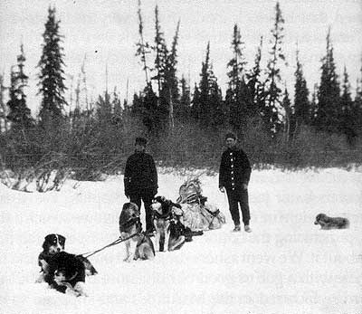
Robert McBride and W. H. Hunt (right) returning from Setting Lake to The Pas, March 1911. Hunt and McBride, along with Robert Scott, traveled 225 miles in just seven days.
Source: Margaret Carter
In choosing our campsite for a night’s bivouac we always looked for a spot where plenty of spruce boughs were handy for use under our blankets. Before we reached our first survey campsite at Manitoba Rapids, the mosquitoes appeared in swarms, so that it was imperative to make use of the mosquito bars (bug houses) we had brought along. Our guide Spence made it a point to always camp near some of his Norway House pals so that protected by a good mosquito smudge, he was able to join in their popular game of black-jack. It was amusing to watch those Cree lads play at cards. They seldom spoke but when they did it was only in undertones. Their voices sounded like a babbling brook, soft and musical.
On the journey downstream, the Hudson Bay Company’s men provided their own food, which seemed to be mostly pemmican and bannock. Their bannock was prepared for the frying pan on which it was cooked by mixing water with the flour in an 80-pound sack (never full). After the water had soaked into sufficient flour for the meal to be served, the dough was taken out of the sack, kneaded a little more, and flattened out in a frying pan. The pan was then set at an angle in front of a fire and baked first on one side and then on the other side, until it was thoroughly cooked. I presume they used a little salt, but I never saw them put it into the batter. We found out later, when we were short-rationed that bannock made in this way really stays with one, “sticks to the ribs” so to speak. It is very satisfying to an empty stomach. [...] These boys also packed along a hunk of “sowbelly”—mostly fat pork. To me this form of meat was always more or less unpalatable. In real cold weather, when no other meat was available we ate the stuff, but not from choice.
The only thing to mar our happiness in the journey down the Nelson was a slight accident that occurred in the shallower water just below Bladder Rapids. We were in water only eight or nine inches deep when we struck a sharp rock, puncturing the bottom of our canoe. Spence felt pretty bad about it. We went ashore, unloaded our canoe, and filled the hole with a gob of good old Bluenose Butter. The butter was manufactured in the Maritimes and supplied to us in cans that closely resembled the cans still used by the Hudson’s Bay Company for half-pound containers of their Imperial Mixture Tobacco. This form of packaging was convenient and sanitary, particularly in hot weather when butter supplies had to be moved in pack sacks and tump lines.
Three Cree women, all over the age of 100 years, photographed by W. H. Hunt in northern Manitoba, 1910.
Source: Margaret Carter
About noon of the sixth day of our trip down the Nelson, we arrived at our destination about half a mile south of Manitou Rapid. We camped on a little meadow on the west bank, a short distance south of the site of the existing steel bridge over the rapid, between the stations Stitt and Arnot.
On the morning following, party No. 3 under F. P. Moffatt started work at a point on the west riverbank at the proposed bridge site. At that point, the river flows through a narrowed channel at a high rate of speed, with a drop of eight feet in one half mile. This channel is only 400 feet wide and all of the Nelson River passes through it. The granite banks on either side are between 45 and 50 feet in height. To that point, the two parties then camped at Manitou had successfully negotiated, by running or portaging, twelve major rapids. They had also crossed Playgreen and Cross lakes, 70 miles of Sipiwesk Lake, making a total distance of close to 620 miles:
On the morning after arriving at Manitou Rapids, while Moffatt’s men were starting to run their trial line southward, Peter Gordon’s party sorted out and transferred their supplies from the temporary camp above Manitou to the site of their first survey camp, below the rapids. From there, they began the location of their line from the north side of the Nelson northward towards Port Nelson.
After most of Gordon’s equipment and supplies had been taken safely through Manitou Rapids, a well-loaded freight canoe manned by John James Flett, Alex Seamore (Simmard), and B. Snider when almost through the treacherous current was caught in an eddy, which caused it to up-end. Seamore, who was in the bow end of the craft was drawn downward, while the other two men were able to swim to shore. Seamore’s body was found in the spring of the following year. Flett and Snider were able to reach the west shore which they followed on foot until they met me at the water’s edge where I was holding the leveling rod for Tom Christianna at a spot near the southwest end of the proposed steel railway bridge.
From that time on, no contact was maintained between the two parties. Gordon completed his line to Nelson House that year, while Moffatt’s party ran a trial line south to Thicket Portage, which was reached late in September. From Thicket Portage, Moffatt ran a final location line, following a preliminary line run earlier by W. J. Clifford, northward to Fort Churchill. From our first camp on the Nelson River we moved to Camp 2, on the north side of what is now called Armstrong River.
While at this camp, Scottie Morris, our draughtsman looked up from his draughting board one day and observed a moose swimming across the stream which was quite wide at this point. Scottie was anxious to see a moose dose up and called to Jack LaBelle, who happened to be in camp that day. Jack and Scottie got into a canoe and soon caught up to the swimming animal. Jack grabbed the animal by the horns and hung on. On reaching the shore, Jack got his leg over the moose’s back, but finally the moose traveled so fast and the bush got so thick that Jack had to let go.
From this camp the line was extended southward about six miles to a point where it was not far from the north shore of a Lake named Edna. Chief Moffatt, having no map to guide him, was of the opinion that the end of the cut line could be reached from a camp set up on a creek which ran into the Nelson about seven miles upstream from Armstrong River. Accordingly, on the 30th of June, camp was dismantled and set up about four miles west of the Nelson, on the creek above-mentioned.
On the next day, July 1st, transitman Charles Bruce led the party northward into the bush hoping to find Lake Edna and the end of the cut line. No signs of it were discovered. On return to the camp, after a day traveling in wide circles, it was decided the topographer Billy Gillespie should take a shotgun and some shells and go with Jack LaBelle back to the end line and fire off his gun at about noon of the following day. The rest of the party started out on another wild goose chase, all the time listening for gun shots. We yelled and yoohooed at half hour intervals all day—and it was a very hot 2nd of July—and listened intently, but heard nothing. After three days of this bush thrashing, the Chief decided we should return to our old campsite and move southward in a small creek which emptied into Edna Lake. By cutting willows that overhung, and by removing debris from the creek bed, we were able to reach a spot in burned timber where we could set up camp.
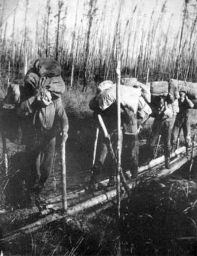
Hudson Bay Railway survey party and packers photographed by W. H. Hunt, 1910.
Source: Margaret Carter
After working from this camp for a few days, we were able—with a portage down our cut line—to reach the shore of Armstrong Lake. Packing all our equipment, including our freight canoes, over this old cut line in the scorching July weather was about as tough a job as I have ever experienced. Flies were bad, water was scarce, and the canoes seemed awfully heavy. I can clearly remember how much I appreciated the intestinal fortitude shown by Russell Lesley. Though quite a few years younger than I was, Russell grimly bore up under the back end of the canoe which he and I had to carry on our shoulders over the stump-strewn, burned-over, freshly-cut survey line. I can well remember lying on my belly on the moss with my arms around a small waterhole which we found beside the line. That water was about the sweetest thing I have ever tasted.
However, we made Armstrong Lake and camped on one of its islands so that if a bush fire which was raging behind and south of us ever reached those parts, our camp would be safe. We stayed on the island for a few days then moved camp to the south end of Armstrong Lake. As the country through which the line from Armstrong Lake south lay in an area which was well away from the then-known water routes, our main camp was moved only once between Armstrong Lake and Thicket Portage, to a point where our line crossed the Pikwitonei Creek.
At the main camp, our tents were left standing. The office tent which housed the draughtsman and Chief, when he was in camp, and the cook tent, were the only ones used there. The transit party and level party made use of shunt camps, to which the packers packed in bread and supplies from the main camp. When operating from main camps, the party often walked six or seven miles back at night. When working from shunt camps, moves were made about every five miles so the men did not have to spend too much time walking to and from work.
At the main camp, our six tents were occupied as follows: No. 1 (cook) tent, in one end of which cook Neil McKenzie slept; No. 2 (office) tent, occupied by Chief F. P. Moffatt, draughtsman Scottie Morris, transitman Charles Bruce, leveler Tom Christianna; No. 3 (rodmen and chainmen) Donald Henderson and James McKay, head and rear chainmen, topographer William Gillespie, and William H. Hunt, rodmen for leveller; No. 4 (topographers and axemen) tent, Robert McBride and Russell Lesley; No. 5 (axemen and packers) tent, George Williams, Andy Pruden, George Sinclair, Isaac Sanderson, and Joe Diamond Johnston; No. 6 (packers) tent, Jack LaBelle, Johnny Harper, and Gilbert Smith. This tent often stood empty, when the occupants were away toting supplies from the caches at Thicket Portage and Split Lake.
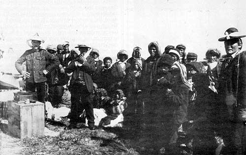
F. P. Moffat (left) of the Hudson Bay Railway survey party demonstrates a gramaphone to local Cree people. Photo by W. H. Hunt.
Source: Margaret Carter
During the months of July and August, bush fires were burning on the west side of the Nelson and another was started by our own men between Edna and Armstrong Lakes. No one who has never witnessed a forest fire can appreciate its terrible work. Incredible as it may seem, the fire which our men started began with a small mosquito smudge made in the moss close by the instrument by the transitman, who made a practice of making a smudge beside him that it could always be seen by the leveler’s rodman, and by himself extinguished.
Well, on this hot July day, the axeman whose duty it was to make a fire for boiling the tea pot shouted “dinner” when the tea was boiled, a hundred yards or so ahead of the forward end of the cut line. The transitman’s smudge was so tiny on this day that the leveler’s rodman and the leveler failed to notice it, and hurried to the boiled tea for lunch and a noon rest. About one half hour later we heard a roar behind us. By this time the flames were jumping from treetop to treetop. Fortunately the wind was in a direction which blew the flames north and east to our cut line, towards Edna Lake where on account of the lake, and an area of brules, and a subsequent rain, it burned itself out. However it might have been much worse, and it taught us all to be doubly careful about lighting smudges. We used more fly dope and fat pork rind to ward off the flies instead of making smudges.
With shunt camps we ran transit, level and topography parties, cutting about 50 stations per day and slept in a different spot each night. The boys carried their blankets and bed rolls with them. Four packers were kept busy bringing grub, two packers bringing food in daily, and the other two packers making their way back to the main camp for another load. With shunt camps, we ran 12 miles of line from the south end of Armstrong Lake to Pikwitonei.
On the Sunday following the twelfth day, no packers had arrived as expected. Urged by my curiosity, I wandered up ahead of the line and climbed a tall pine near the creek’s bank to look for a lake in the vicinity. Imagine my surprise when I reached the top to see a canoe coming up Pikwitonei Creek. I promptly climbed down and yelled at the canoemen, who turned out to be Jack LaBelle and my friend Johnny Harper. They were looking for us and had food. As our line had not crossed the creek, they might have had trouble in finding our camp, which was half a mile north of the creek.
During the week following the packers brought the cook, camp and all equipment to Pikwitonei, so we had comfort for a few days after that, until we resumed the shunt camp business about August 1st. Working from Pikwitonei to Thicket Portage was the longest shunt camp stretch we experienced—36 miles all-told. We reached Thicket Portage about the middle of September and it started to rain. I had purchased from Andy Pruden, a buckskin jacket. When it was cold I used to wear it. It was very comfortable.
After our supplies began to get low due to the long hikes the packers had to make, Tom Christianna and I set out one day for Thicket portage so we could blaze a line for the packers’ guidance when bringing supplies from the Portage. On that day it rained like the very dickens, and my moosehide jacket flapped around me like a wet blanket, cold and clammy. However, late in the afternoon we arrived at Thicket Portage and finally found the cook camp and office tent. From that time on we fared better.
At Thicket Portage we tied onto Clifford’s trial line to Fort Churchill, and the whole party celebrated with copious supplies brought from the cache at Landing Lake (which cache had been set up by a Mr. Campbell and Mr. Barber, who had accompanied us to Norway House in May).
We set out for Armstrong Lake, 45 miles away via Wintering, Partridge Crop, and Natawanan Lakes. The wind was from the south, and it blew very hard. Jack LaBelleand I travelled together that day by using a blanket stuck on a poplar pole mast, with another green poplar pole for a boom. We sailed away so fast we lost sight of the rest of the party. In the afternoon, after sitting on a point on Natawanan Lake for three hours, we began to worry about the others. Eventually they hove into sight. They had found the lake so rough they laid up on shore until the wind subsided.
On the day following, we set up our camp at Standing Stone Falls and Rapid, at the west end of the portage between Natawanan Lake and Armstrong Lake. At that point we again tied onto engineer Clifford’s trial line to Churchill, and made an observation on Polaris. We then proceeded to work northward on the Churchill Route, paralleling the east side of the Grassy River. On this line we were able to make full use of our canoes for toting supplies and for traveling back and forth between our work and camp.
For the most part, the weather was clear and cool. The flies had disappeared. We could cut about seven miles of line from each camp without having to walk more than three or four miles to work. Usually our line was less than a mile inland from the Grassy River and the east shore of Witchai Lake. We made good progress and with three camp moves; we set up headquarters at Mink Falls at the north end of Watchai Lake. At this camp things started to go wrong.
We made a practice of moving camp every odd Saturday, and after we had made our sleeping quarters comfortable, we rested on the Sabbath Day. By this time we were in the month of October, and water rolled off the ends of our paddles in globules. Thin ice began to form along the shore which we had to break to land, suggestive of what we might expect soon.
Page revised: 13 June 2014