by Robert M. Bone
Department of Geography, University of Saskatchewan
|
Bill Waiser, The New Northwest: The Photographs of the Frank Crean Expeditions, 1908-1909. Saskatoon, Fifth House Ltd., 1993. 125 pp., ill., maps. ISBN 1-895618-22-3.
Myths abound in all societies and Canadians hold dearly to the northern treasure house myth. Frank Crean’s interpretation of the lands lying polarwards of the North Saskatchewan River gave credence to this myth. In Crean’s case, he saw vast stretches of fertile agricultural lands where there was none.
Bill Waiser of the History Department at the University of Saskatchewan has captured one example of this myth. Owing to good fortune, Professor Waiser became aware of the Crean photographs held by the Saskatchewan Archives Board. From the photographs and what little remains of the official records of Frank Crean’s expeditions into this fur trapping country of the Saskatchewan Northwest, Waiser undertook what can only be described as a salvage operation. Most records about the Crean expeditions were destroyed in the 1930s. Only three slim files exist in the National Archives of Canada. Fortunately, the Saskatchewan Archives Board obtained the photographs of the Crean expeditions in 1978 and Bill Waiser has been able to weave together a fascinating book—a mixture of 89 carefully selected Crean photographs and thoughtful descriptive comments by Waiser.
Frank Crean, a civil engineer in the Department of the Interior undertook two explorations of the northern edge of agricultural lands in Alberta and Saskatchewan. His first expedition took place in the northwest of Saskatchewan in 1908. His overly optimistic reports created a false image of the agricultural potential of this region. But such reports were well received by his superiors in the Department of the Interior. In 1905, Frank Oliver, the federal minister of the Interior, received a troubling report from one of his staff members, Robert Young. This report suggested that the agricultural lands south of the North Saskatchewan River were soon to be occupied by the flood of settlers from Europe, Canada and the United States. Young believed that a new agricultural frontier may be found beyond the North Saskatchewan River and he recommended that expeditions confirm his belief. Young chose Frank Crean to head these expeditions. His objective was to find and describe the agricultural lands of the Saskatchewan Northwest.
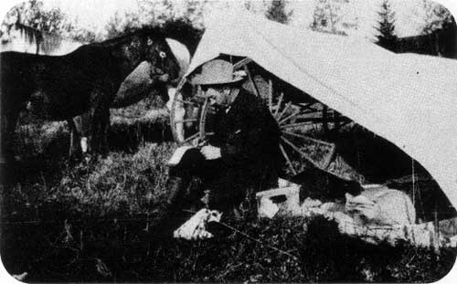
Frank Crean at Green Lake, Saskatchewan, 1908. From: The New Northwest: The Photographs of the Frank Crean Expedition, 1908-1909.
Source: Saskatchewan Archives Board
But what do the photographs show? For the most part, they provide the reader with a glimpse of life in land of the Métis and Indians in 1908-09. The Northwest was a key water transportation route for the fur trade in days gone by. At that time, Portage La Loche was the link between the Churchill River and the Athabasca River. Beyond were the rich fur lands of the Mackenzie River. To the east, the fur trading capitals of Montreal and London. Furs moved to these capitals along a vast river system while trade goods were sent to the many fur trading posts by the same transportation network. The economies of the Indian and Métis communities along the Churchill River depended as much on the transportation industry associated with the fur trade as on the trade itself.
Local production of hay, potatoes and other crops were encouraged. By 1908, the glory days of the fur trade were gone and the Northwest was in a transition state. Those engaged in fur transportation industry and the production of vegetables for the traders were gone. Technology in the form of a railway to Edmonton and the Athabasca Landing Trail had made the old water route redundant. Edmonton had become the gateway to the Mackenzie Basin and its rich fur trade.
Professor Waiser has demonstrated the depth of the belief held by Canadian officials that the fertile Northland was virtually endless. Geography proved this belief false.
Page revised: 11 April 2010