by Robert Robson
Institute of Urban Studies, University of Winnipeg
Manitoba History, Number 16, Autumn 1988
|
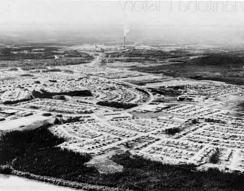
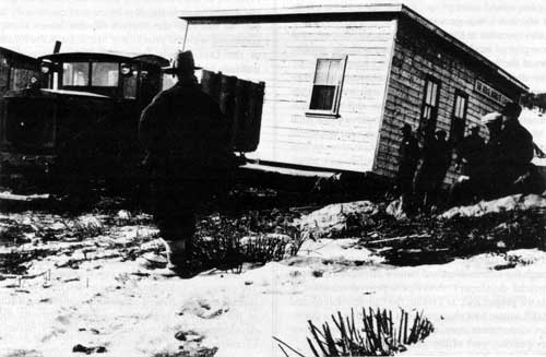
Thompson, Manitoba, circa 1970.
Source: Archives of Manitoba, Thompson 25, N18667.
The resource town may be defined as “any community whose economic base depends on resource extraction or processing.” It is a manifestation of the twentieth century expansion of the northern frontier. [1] Like its predecessors the fur trade post or the fishing village, the resource town is a product of colonial exploitation. The twentieth century town, whether it is oriented toward minerals, lumber, pulp and paper, hydro or nuclear power, is the product of an “industrial heartland.” [2] Resource communities are established to house the workers involved in the provision of the raw materials for the manufactories at the core area. The metropolitan relation-ship is so pronounced that it has led G. A. Stelter, in a paper entitled “The Urban Frontier in Canadian History,” to actually apply the term “colonial town” to the resource community. [3] In further describing the colonial aspect of the twentieth century resource community, Stelter maintains that:
... these new towns represent a continuity with earlier colonial towns in that many of them are under the direct control of an outside imperial power ... [4]
The resource town is indeed a “vassal of its metropolis” and, as suggested by Doug Baldwin in his study of the urban frontier, often serves as an “agent” for the transferal of social, cultural and economic characteristics. [5]
Tracing the line of the Canadian Shield as it bisects the province, Manitoba’s resource towns have emerged in linear fashion across the north. Although as Tough and McCann argue more recent developments also suggest a “filling-in” process, the resource town phenomenon is clearly based on a series of linkages. [6] Including transportation, hydroelectric power, support services and even retail facilities, these linkages from one community to the next underscore the unique quality of the resource town experience. The growth of communities such as Bissett, Pine Falls, Sherridon, Flin Flon, Snow Lake, Lynn Lake, Thompson, Pinawa and Leaf Rapids provides evidence of the stages in the resource town building process.
In its earliest configuration the resource town was a product of company initiative. As such, the facilities provided to accommodate the townspeople were almost always those facilities deemed essential to the production of the resource. While in some cases the company attempted to provide a wide array of quality facilities, in the majority of town sites the company supplied only a nominal level of community services. This, however, dramatically changed in the post-1930 period when, with the increasing participation of the provincial government, communities were designed with greater consideration of quality of life. This tendency was further accentuated in the post-World War II era, when government involvement encouraged the greater incorporation of “social and economic principles into the fabric of physical planning.” [7] Responding to the sovereignty issues of the immediate post-war period, the challenges of northern expansion, the increasing acceptance of regional planning ideas, the proliferation of newly articulated innovative planning schedules, the competitiveness of the labour market, and also because of a rather negative reaction to the company town experience, the provincial government began to participate readily in the development of Manitoba’s resource towns. Evolving from the ramshackle camps of the early period to the company-government orchestrated communities of the inter-war years to, finally, the “model towns” of the post-war era, resource communities are indeed a prominent feature of the northern Manitoba experience.
One of the earliest examples of a resource town in the province is the community of Bissett. Located on the shore of Rice Lake approximately two hundred and sixty kilometers northeast of Winnipeg, Bissett was the focal point of the “central Manitoba” mining district. [8] As such it offers not only a good study of the helter-skelter nature of pre-1930 resource community development but also provides valuable insight into the problems of the single industry town. [9]
Prospecting activity in the Bissett region can be traced to the late 1800s. According to local history sources, several gold mines operated in the area prior to the turn of the century. [10] Although production was limited, the promise of mineral riches attracted a number of syndicates to the district and by the mid 1920s there were upwards of eight companies developing local claims. [11] In 1927 the San Antonio Gold Mine Ltd. Company also entered the field and with the consolidation of its operation between 1927 and 1933, the San Antonio came to dominate the district’s mining industry.
The community complexion of the Bissett region was directly related to the nature of the mining industry. Several small mining camps which had been established in conjunction with the various mining operations offered the only semblance of community until well into the 1930s. These camps provided limited accommodation and little in the way of actual amenities. Describing the quality of these facilities, one former resident recalled that:
Homes were erected wherever there was a piece of level ground and a minimum amount of clearing of bush to accommodate the building. Construction material was log green spruce lumber cut locally, powder boxes, flattened metal containers ... [12]
In 1933-1934, however, the mining camp composition of the community changed. At the instigation of the San Antonio Gold Mining Company a permanent town site location, eventually known as Bissett, was selected and the transition from the small, localized camps to the more centralized property encouraged. Built on property leased by the San Antonio Company, the Bissett town site slowly took over the community functions of the mining district. San Antonio, for its part, demolished its camp facilities and on the new town site erected two large bunkhouses, dining facilities, a staff house, school house, hospital, store, butcher shop and a warehouse. [13] It also undertook to provide the fledgling community with services such as heat, power, sewage disposal and water works. By 1935, with a population of approximately eight hundred inhabitants, Bissett was clearly on its way to forming the hub of the district. [14]
While the construction of Bissett was typical of the pre-1930 frontier resource town experience, Pine Falls gives evidence of the more positive aspects of community development during this era. Located on the Winnipeg River approximately 120 kilometers north of Winnipeg, the community of Pine Falls traces its origins to 1926 and the timber stands of central Manitoba. Pulp and paper towns are traditionally the most permanent form of resource community, and Pine Falls became an orderly, well-designed, stable town because of the activity of the Manitoba Paper Company. Designed by L. E. Schlemm of Montreal under the supervision of Manitoba Paper Company engineers, the community featured the separation of industrial and residential areas, a system of main and secondary thoroughfares, greenbelt areas, a curvilinear street pattern, and primitive zoning techniques.
The layout of the town has been described as resembling “the back of a terrapin.” [15] Centring on a village green, the town site fanned out in a semi-circular fashion away from the heart of the community. Located at the core were both park space and the commercial zone. In an effort to enhance the aesthetic value of the central area as well as to provide for a common meeting place, the village common included tennis courts, a playground area and bowling facilities. Directly opposite the park area and intended to function as a downtown block was the commercial district. Focusing on the community club, the commercial complexion of the downtown area reflected the private-enterprise nature of the community. Consisting of a number of small shops, the commercial area was deemed adequate to meet the immediate needs of local residents.
The street pattern echoed the semi-circular nature of the town site plan. The community was serviced by two main arteries from which the “crescents and circles” of residential development evolved. [16] The one major thoroughfare skirted the community and in fact was an extension of the highway to Winnipeg. It defined the other limits of the town site and in some respects helped to discourage peripheral growth. The second main artery or the “central boulevard” bisected the town site and formed the community’s main street. This was reinforced at the core with the development of a double boulevard roadway, consisting of two one way avenues and separated by a “planted island.” [17]
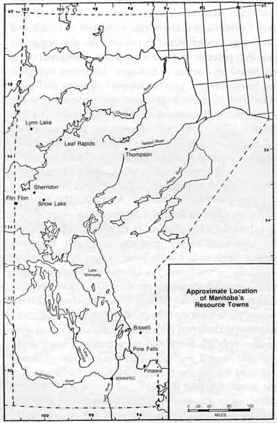
Approximate location of Manitoba’s resource towns.
In designing the town site, town planner J. P. Mertz said the company’s main effort was to “adopt the English type of cottage to local conditions and group the various types in pleasing perspective.” [18] According to Mertz, the paper company readily incorporated British planning concepts in the styles of dwelling houses and also in the overall design of the town site. The “narrower roadway” for example, as incorporated at Pine Falls, was an admitted attempt to replicate the British village system. [19] Indeed, the Manitoba Paper Company attempted to implement a number of British planning ideas in the design of the community.
The paper company in coordinating town site development sought to provide community facilities geared to employee wages. In this fashion and after a fairly extensive investigation of other mill towns, the Manitoba Paper Company selected thirty housing types of standard frame and stucco construction. For the most part the dwellings were of the five to six room type and ranged in cost from $2,500 for unskilled workmen to $5,500 for the skilled labourer. [20] Two staff houses for unmarried personnel as well as a finer grade of dwelling for company superintendents were also provided by Manitoba Paper.
As is often the case in the resource town, utility services that were developed for the mill site were co-opted for the community at large. [21] In this fashion, water, sewage disposal, and hydro-electric power facilities all evolved from the industrial plant. Hydroelectric power for example, ran from the mill sub-station directly to the individual housing units. [22] These units in turn were equipped with light, power wiring, electric cooking ranges, and hot water heaters. The company’s benevolence went much further than cooking ranges as some of the more incidental services included lawn mowers, garden hoses and even neighbourhood “service stations.” [23] In all cases however, whether it was garden hoses or electrical lighting, the Manitoba Paper Company supplied a fairly wide range of services in order to guarantee the availability of a much needed labour force.
The model industrial town concept was very much a part of the paper company’s plan for Pine Falls. It borrowed readily from the Garden City tradition of the rural community in order to provide a pleasant living environment. In doing so, however, the company was the sole authority for the development of the town site plan. In many respects it was quite exceptional for its progressive approach to community planning and while it did indeed promote the model town site, it did so on its own initiative.
In 1930 when the province of Manitoba was granted the right of resource management by the federal government, the formative era came to a close. The demand for the transferal of natural resources which was first articulated by Premier Norquay in 1881, sporadically reappeared until 1913 when the three prairie premiers unanimously agreed to press the issue as a united front. [24] By 1922 and after much debate, Mackenzie King conceded the point and addressed a proposal concerning the transfer issue to the three governments. In this regard King noted that it
... is desirable and just that such adjustments be made between the Dominion of Canada and the Prairie Provinces with respect of their natural resources as will give full recognition to the principle that in this respect they are entitled to be placed in a position of equality with the other provinces of Confederation. [25]
The issue of compensation for alienated lands proved to be a stumbling block to the transfer. In 1928, through a federal Order-in-Council, the Royal Commission on the Transfer of the Natural Resources of Manitoba was established and an arbitrated agreement was reached. As a result of the Commission’s findings, a plan of annual subsidies was established in lieu of alienated lands and the three prairie provinces were eventually granted authority over Crown Lands.
The ramifications of the resource transfer issue were most significant to the development of resource communities. In general, prior to 1930, town site affairs were the responsibility of the federal Department of Railways and Canals. [26] Working in co-operation with the Department of the Interior, community design when needed was planned by the two federal ministries and usually administered by the Canadian National Railway. [27] The federal government however actually had little direct impact on community development as in most cases the resource firms continued to dictate town site form.
The Manitoba government’s authority over resource community development was consolidated in 1928 when, prior to the transfer of natural resources, the federal government allowed “certain strategic points” of development to pass to the provincial authority. [28] This included the town sites of Churchill, Flin Flon, Sherridon and Cranberry Portage. The provincial government readily accepted the responsibility for community affairs and quickly attempted to implement the machinery necessary to oversee continuing development. In an effort to define government policy concerning new town sites, the provincial government underscored two predisposing issues. In detailing the importance of proper site location and preliminary investigations in the pre-planning stage, the provincial government committed itself to the development of a viable northern economy. In discussing the regional nature of provincial government policy W. E. Hobbs, Provincial Engineer, emphasized the importance of district planning. [29] This was applied directly to the individual townsite and as further suggested by D. McKenzie, Minister of Mines, implied “that none of the town sites ... will be closed in the ordinary sense.” [30] The policy pursued by the provincial government emphasized the regional aspect of the northern community with a view to the development of a functional northern economy.
By the 1930s the pace of northern development had been stepped up to a point where railway, hydroelectric power, mining and, to a more limited extent, forestry dominated the scene. The process of northern expansion was largely confined to the Canadian Shield area of northern Manitoba. The district of “New Manitoba” was clearly the focus of the new expansionary thrust. [31]
The community of Sherridon, located approximately 900 kilometers north of Winnipeg, was one of the first communities in the north to develop under the authority of the provincial government. The town site, which was established by the Sherritt Gordon Mines Limited Company, is perhaps most notable through its association with the community of Lynn Lake in 1952. In the winter months of 1952 the community of Sherridon was disbanded and moved in its entirety some 190 kilometers north to the newly developed town site of Lynn Lake. [32] From 1928 to 1952 however, Sherridon was a thriving resource community, completely dependent upon the Sherritt Gordon Company for its livelihood.
The original appearance of the community was very much typical of the temporary town site phenomenon. Designed to meet the immediate needs of the construction workers and cited as a “drill camp,” the early configuration of the town site followed no specific lines of development and in general reflected the rudimentary nature of the frontier. [33] Prevailing from 1927-1928, the drill camp was mostly composed of tents and primitive log structures. When, in 1928, the Sherritt Gordon Company committed itself to the development of the ore body, it also undertook to regulate town site affairs. This in effect concluded the era of the temporary town site and foreshadowed the greater participation of the company in town site development.
In an obvious attempt to disassociate itself from the helter-skelter nature of the temporary community, Sherritt Gordon established the location of the permanent town site one mile removed from the original site. On the basis of a lease obtained from the provincial government, the mining company was granted the authority to administer the property for town site purposes over a period of fifty years. [34] While the mining company was seemingly granted carte blanche authority to oversee town site affairs, the provincial government retained an element of control through its newly acquired administrative responsibilities.
In an effort to expedite town site development, the mining company created a second town site authority in the Sherridon Development Company. [35] A wholly owned subsidiary of the mining company, the Sherridon Development Company assumed responsibility for town site design, development, and administration. It almost immediately set about the task of formulating a program for development and, after extensive preliminary surveying, defined a general town plan. Consisting of two commercial zones and three residential areas, the town of Sherridon slowly took shape in the years 1928-1929. The focus of the community was clearly intended to be the central business district. Although the company encouraged the privatization of retail services, it still retained control over the district through the parent company’s land holdings. Consisting of two business blocks and mostly composed of general mechanizing shops, the downtown area formed the hub of the community.
The residential districts of the town, like the business areas, reflected the central place of the mining company. Company owned housing, for example, was the dominant form of accommodation until well into the 1930s. Even then, many of the eighty-five privately owned homes were subsidized by the mining company. [36] Very much in the tradition of the company town, the Sherridon Development Company prided itself on its all inclusive housing program. The restrictive nature of the company’s town site scheme eventually forced the provincial government to provide alternative housing facilities elsewhere. Indeed in what appears to be the only episode of government intervention in the Sherridon planning process, the province
... laid out lots elsewhere in the area that provided accommodation for people who dislike the idea of a company town and also for many people who would not qualify as desirable citizens for Sherridon. [37]
While the provincial government claimed to favour the well planned, open community, it did little in the early years to initiate its development.
A similar pattern of development occurred at Flin Flon some 100 kilometers south of Sherridon. Here the provincial government attempted to exercise greater control of town site affairs, but Flin Flon too developed as something of a company town with little consideration given to progressive planning. The Flin Flon region’s copper ore potential had attracted prospecting activity as early as 1915 when the initial discovery was made. The claim passed through several hands until, in 1926, the Complex Ores Recoveries Company secured the option on the property. After a series of favourable test results were obtained on the value of the ore, the Recoveries Company combined in partnership with two other mining firms to acquire a government charter in December of 1927. The charter consolidated some 153 mining claims on nearly 6,000 acres of land, under the development umbrella of the Hudson Bay Mining and Smelting Company (HBM&S). [38]
The initial form of town site development at Flin Flon was the frontier-type temporary town site. Consisting of several log structures that were placed in no particular order, the original community typified the rough and ready northern frontier. As early as 1927, however, the company recognized the needs of town site development and established the Community Development Company (CDC) to co-ordinate town site affairs. [39] Although it was not chartered as an official corporate body until 1931, the CDC in 1927 surveyed what was to become the main street and began the subdivision of a potential town site.
Shortly after the HBM&S Company had initiated development, negotiations were started with the federal government to locate a suitable permanent town site location. In 1928 the federal government authorized the creation of a 620 acre town site under the administration of the Department of Railways and Canals. [40] This property, which was approximately two miles from the plant site, was actually surveyed by the federal government but with the transfer of natural resources and other administrative problems the scheme was never completed.
With the termination of the natural resource question, authority was transferred to the provincial government and actually increased the uncertainty surrounding the Flin Flon town site. Because the province recommended the Ross Lake site as defined by the federal government, the company on its own initiative developed a “temporary town site” adjacent to the mine site. [41] As a result of the questionable state of town site affairs, a second and then a third town site appeared in the Flin Flon region. Both the “Channing” and “Tobacco Road” areas developed as alternative housing sites, offering residents the opportunity to locate away from company and community authority.
The town site situation worsened as the mining company moved towards production. As the issue lingered in uncertainty the problem of inadequate town site facilities became more and more evident. Between 1927 and 1931 the Community Development Company was regularly presented with complaints concerning everything from the “lack of proper sanitary facilities” to the “smoke nuisance. [42] Eventually, during the winter of 1930-1931, the HBM&S was forced to undertake its own investigation of potential solutions to the town site problem. [43] While this further emphasized the inadequacies of the temporary town site, it did not produce an immediate solution. A solution came eventually in July of 1931 when the provincial government offered the HBM&S “restricted town” status. [44] Embodied in the Flin Flon Town Planning Scheme, the proposal established a three mile square town site, complete with business, residential and warehouse zones. [45]
The 1931 Planning Scheme also established a local authority to administer town site affairs. Intended as a transitional authority between company control and municipal government, the Community Development Company was officially sanctioned to co-ordinate town site development. Composed of provincial government representatives, HBM&S personnel, and representatives from the community at large, the CDC assumed the responsibility for the survey of lots, the setting of prices, the implementation of the survey and the provision of adequate utilities. [46] The major task confronting the CDC was the realignment of the temporary town site into a permanent configuration. An estimate in the Flin Flon Miner in October, 1931 predicted that ninety per cent of the buildings already erected on the temporary town site would have to be relocated. [47] Some buildings were required to be moved only a matter of feet while others had to be completely uprooted in order to satisfy the town site survey. In some cases—particularly in the unauthorized business district where commercial establishments were shut down because they were operating outside of the newly created business zone—the CDC wielded an inordinate amount of power. By April of 1932 the majority of buildings in the town site had been moved in compliance with the regulations of the town planning scheme, and at last order was beginning to prevail.
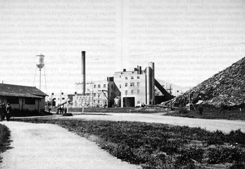
Pulp mill, Manitoba Paper Company, Pine Falls 1938.
Source: Archives of Manitoba
Although the provincial government was to one degree or another involved in both the Sherridon and Flin Flon projects, it was in the post-War era that it finally began to define a resource town policy. The Local Government Districts Act, which was assented to in April of 1944, was a fairly broad attempt to provide local administration for “unorganized” or “disorganized” municipalities. [48] By 1945, in an effort to refine the local government district initiative, the province amended the founding legislation to apply more specifically to “Industrial Town sites.” [49] On the basis of the legislation the Lieutenant-Governor-in-Council in conjunction with the Municipal Commissioner and the Minister of Mines and Natural Resources, was given the power to incorporate as a local government district any community
... in unorganized territory adjacent to a place where mining or other industrial operations is or are being carried on, for the purposes of administering the community... [50]
In further detailing the particulars of the industrial town-site, the legislation made reference to town planning, taxation, public works, land subdivision, and land sales. While the act was still fairly general in its scope, by defining a central place for the Municipal Commissioner and the Minister of Mines and Natural Resources it provided for a measure of provincial government control over resource town development. Indeed, in many respects the Local Government Districts Act was the foundation upon which future northern development would continue to be based.
The community of Snow Lake, located in the Wekusko Lake area of northern Manitoba, was the first mining town in the province to be developed under the Local Government District Act of 1945. It was created under the auspices of the tri-partite agreement signed in 1947 between the Minister of Natural Resources, a representative of the newly created Local Government District, and the Howe Sound Exploration Company Limited. The town site, which was designed to house approximately 1,500 inhabitants, has been described as having set the “pattern [of development] for further industrial town[s]” in the province. [51]
The Howe Sound Exploration Company was a subsidiary of the New York based Howe Sound Company. It had become active in the Wekusko gold fields as early as 1940 and by 1949 had brought into production a five compartment mineshaft and a 2,000 ton per day capacity milling plant. Beyond its initial commitment to the industrial site, the company also contributed $150,000 to the construction of a 37.5 mile all-weather road and an eventual sum of $315,000 to town site development. [52] As maintained by J. P. de Wet, the company willingly supplied capital investment in order to facilitate the extraction process.
The precursor to town site development was the agreement of 1947. It established a 150 square mile Local Government District within which the community was intended to evolve. [53] The rather large district defined by the agreement was designed in an effort to control local development. The land management techniques inherent in the agreement attempted to centralize community growth and thwart the emergence of peripheral or fringe areas.
The town site location was actually selected by the mining company. After extensive preliminary investigations which included topographical surveys and contour mapping, the Howe Sound firm chose a site on the shores of Snow Lake, south of the mining facilities. The planning and subdivision of the town site property however was the responsibility of the provincial government. [54] Working in close co-operation with the mining company, the province divided the site into industrial, commercial and residential areas. The main focus of the plan was the commercial section of the community which was designed as the central core area. This business section was eventually augmented by the community’s public buildings, and it formed the hub of the Snow Lake town site. The residential zones were planned for both sides of the commercial district and in theory allowed for equal access to the core area. The industrial zone was that area designated as mining property. There was a modest effort made to separate the plant site from the town site proper but the two remained within walking distance of each other. Beyond the mining facilities no consideration was given to the development of light or service industry and the community quite definitively evolved as a single enterprise town.
Although the provincial government implemented the town plan, the actual costs of development and maintenance were borne by the Howe Sound Company. The preliminary work, which included surveying, town site clearing, street work, the laying of sidewalks, the installation of water mains, and the construction of both a sewage system and of electric power facilities, was undertaken by Howe Sound at a cost of $175,000. [55] All of this work was completed before the actual construction of the town site commenced, and while the company orchestrated the development it was closely scrutinized by the local administrator who was appointed by the provincial government in July of 1947. As the preliminary work was nearing completion, the physical form of the community began to take shape. Most housing erected was owner-occupied. The company itself built a guest house, a staff house, a single men’s bunkhouse, as well as several public service buildings, but through an elaborate “housing loan plan” encouraged the privatization of the town site. [56] In this manner lots were sold to prospective homeowners and the company attempted to distance itself from the costs of maintaining a company town.
The development of Lynn Lake in the period from 1945-1952 was something of a throw back to the previous era. Although the provincial government had the opportunity to participate in the scheme, it actually provided little more than supervisory assistance. Once the Local Government District was created in 1951, the Sherritt Gordon Mining Company assumed the lead role in the creation of the community. Similar to the Sherridon or Flin Flon experiences, the mining company coordinated the local initiative.
The discovery of the Lynn Lake ore body occurred in the fall of 1941. Although it remained a “well guarded” secret until 1945, the initial find was rich enough in nickel content that it stimulated Sherritt Gordon’s interest in the vicinity’s mineral potential. [57] By 1945, with the decreasing value in production of the Sherridon Mine, the Sherritt Gordon company undertook an extensive prospecting and staking operation in and around the future site of Lynn Lake. Encouraged by positive test results, Sherritt Gordon initiated a variety of preliminary investigations. Much of the equipment and the manpower required for the undertaking was supplied from Sherridon. By the winter of 1946-1947, the route from Sherridon to Lynn Lake was well established and the arrival of “compressors, shaft timbers, drills [and] prefabricated huts,” was almost a daily occurrence. [58] Nonetheless, the town site itself was still “three or four years” away from development. [59]
The regularity of the “tractor trains” increased through the winter seasons of 1948 and 1949. By the winter of 1950, the Sherritt Gordon Mining Company in co-operation with the Patricia Transportation Company, had begun the process of relocating the town site. [60] Approximately six houses were moved during the winter of 1950 and in 1952, the peak year of relocation, sixty houses travelled the Sherridon-Lynn Lake highway. [61] By August of 1951, Lynn Lake’s housing stock consisted of one hundred and twenty-one units, all of which had been relocated from Sherridon. [62] Justifying the move on the basis of economy, Sherritt Gordon officials argued that it would have “cost a small fortune to build a comparable house from scratch at the new mine.” [63] As articulated in the Winnipeg Free Press
... One house with 680 feet of floor plan was built for $2,400 in 1937. To build new today it would cost $7,000 ... It will cost roughly $1,000 to move from Sherridon. [64]
In 1951, with the community’s permanence virtually assured, Lynn Lake was designated a Local Government District by the provincial government. With approximately 507 inhabitants and the appointment of a resident administrator, Lynn Lake acquired the title of “Manitoba’s most northern mining town.” [65] As such it blossomed into a fully developed single industry town. While Lynn Lake, like its predecessor Sherridon, would eventually fall victim to a depleting resource base, it represented a most progressive response to community development.
The Thompson town site is perhaps the most noted of all Manitoba’s resource communities. Developed to house the workers of the International Nickel Company of Canada’s (Inco) extractive facilities, the community is located approximately 370 kilometers northeast of The Pas. Tracing its history to a 1956 agreement between the province of Manitoba and Inco President H. J. Wingate, the community was designated as a “model industrial town” and was intended to accommodate 8,000 inhabitants. [66]
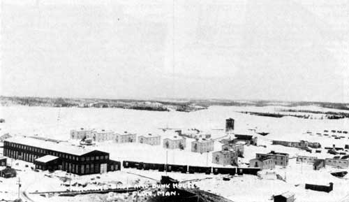
Machine shop and bunk houses, Flin Flon, 1920s.
Source: Archives of Manitoba
In 1946 Inco initiated its program of exploration in northern Manitoba. By 1949 a rich nickel area had been located by the company in the vicinity of Moak Lake. Through the course of the following seven years and after an investment of over one million dollars, Inco had isolated twenty potential sites for further development. [67] In 1956 however the Thompson ore body was discovered and Inco became firmly committed to the development of northern Manitoba’s nickel potential.
On 5 December 1956 the agreement upon which the Thompson project was based was signed by then Premier Duff Roblin and Inco President H. J. Wingate. [68] It delineated the particulars of the enterprise and clearly indicated that Thompson was not intended to be a “company-town.” Apparently at the urging of the company and largely on the basis of its previous experiences in community affairs, Inco sought to create an open town complete with the private ownership of town site lots. [69] Although the company’s efforts in this regard remain somewhat suspect, particularly considering its treatment of union organizers during the years 1956-1958, the agreement did indeed establish the open nature of the community. [70] The crucial factor in maintaining the open status of the town, however, was the participation of the provincial government.
The first stage in the growth of the community was the creation of a Local Government District. Encompassing some 975 square miles of land, the Mystery Lake Government District as established in 1956 was an obvious attempt to preclude unwanted development. [71] It was also an effort on the part of the provincial government to include the industrial plant within the administrative district for the purpose of local taxation.
The 1956 agreement concisely outlined the duties and obligations of each of the three parties in the development of the town site. The provincial government assumed a supervisory position and functioned primarily as liaison between the local administrators and the mining company. The local administrators a representatives of the Local Government District were assigned the task of overseeing town site development. This included the administration of sewer and water services, the sale of land, the regulation of building form and even the appointment of school trustees. Inco assumed the brunt of responsibility for town site development. At its own expense it was required to:
It was estimated in 1960 that Inco’s total expenditure on town site development was well in excess of $8.5 million dollars. [73]
Although authority within the town site was well defined by the agreement, the particulars of town site location were less clearly delineated. Indeed section two of the agreement in describing town site location simply indicated that it
... would be approximately three thousand (3,000) acres in area and lying some two (2) miles distant from the plant site ... [74]
Initial responsibility for town site location rested with Inco. In June of 1957 however, Inco passed its planning authority to the province of Manitoba when it requested that the Planning Service of the Province assume responsibility for town site design and development. Working in close cooperation with the engineering firm of Underwood McLelland and Associates of Saskatoon, the provincial government instituted a preliminary design research program. In coordinating activity from approximately August 1957 to January 1958, the program sought to establish a plan that the “Province of Manitoba, the Company and its employees will be proud of.” [75]
As several preliminary plans “were drafted, discussed, thrown out or revised,” site investigations indicated that the most appropriate location of the town site proper was on the south side of the Burntwood River, nestled in a slow meander of the river. [76]
Although the engineers’ reports indicated that the whole district offered little in the way of optimum site location, the chosen area was dictated by several predisposing features, including the following:
Once the site was determined, as it was by December 1957, the provincial government set about the task of implementing “The General Development Plan.” As it came to be applied, the plan encouraged the use of buffer zones, the separation of vehicular and pedestrian traffic, the development of a commercial-civic focal point, the incorporation of super blocks with cul-de-sacs, crescents and bays as the major element of the street pattern, and balanced single and multiple family dwelling distribution. In a most detailed fashion the Metropolitan Planning Service defined land use requirements in terms of:
|
Single family dwellings |
284 acres |
|
Multiple family dwellings |
54 |
|
Park sites — 2 acres per 1,000 |
16 |
|
Elementary School site (2-12 rooms at 6 acres each, 1-20 rooms at 13 acres) |
25 |
|
High School and recreation area (high school at 18 acres, recreation area at 24 acres) |
42 |
|
Civic centre — public buildings (Central commercial area including neighbourhood stores — approx. 3½ acres per 1,000) |
44 |
|
Light industry and heavy commercial (no heavy industry in townsite) |
55 |
|
Hospital site approx. 2 acres per 1,000 |
18 |
|
Utilities, cemetery and storage area |
10 |
|
Natural areas, selectively cleared buffers |
55 |
|
|
608 acres [78] |
With all the preliminary work completed during the winter of 1958, the construction process began in the early spring. By November of 1958 occupancy of the town site was well underway. Most of the housing was built by private contractors and ranged in price from approximately $9,860 to $14,000 per unit. [79]
Unlike Thompson, Pinawa was developed on the initiative of the federal government. Cited as Manitoba’s “first atomic age town,” the community was established to house the employees of the Whiteshell Nuclear Research Establishment. [80] Located approximately 100 kilometers northeast of Winnipeg, Pinawa, like its predecessor Deep River, Ontario, was created by the Atomic Energy Commission of Canada (AECL). Very much similar to the traditional resource communities, Pinawa’s raison d’etre was to house the workers involved in the resource processing industry. On the basis of a June 1960 agreement between the Atomic Energy Commission and the Manitoba provincial government, the town site became the province’s first nuclear energy dependant community.
The enabling agreement of 1960 quite clearly defined the various responsibilities of community development. The provincial government for its part created the Local Government District of Pinawa and appointed its local administrator but beyond this and a rather limited funding role, the province had little impact on community development. AECL was given almost carte blanche authority in the development of the town site. Indeed as suggested by S. H. Dietze, Pinawa was created with “little government interference or assistance” and was “administered very much like a closed company town.” [81] The Commission coordinated the development of the town plan, constructed roadways, provided community services such as water treatment, supplied recreation facilities and erected public buildings such as the town office, police and fire stations, the hospital and even the schools.
Moving the Royal Bank, Flin Flon, 1931.
Source: Archives of Manitoba
The pre-planning stage of the Pinawa town site gives evidence of extensive background analysis on the part of AECL. This is particularly true in consideration of the variety of population studies initiated by the commission to determine the final complexion of the town site’s population. Its previous experience of town building at Deep River, Ontario, gave the Commission insight into the potential population of the community. In direct reference to the Deep River experience, AECL predicted comparable population characteristics and further estimated a work force composed of the following:
Research personnel |
1,046 |
|
Primary population |
4,168 |
|
Ancillary |
523 |
|
Total |
5,737 |
[82] |
Of particular note and directly associated with the sophisticated nature of the atomic energy industry, the Commission also determined that the community’s inhabitants would be relatively young in age and well-educated. As a result of its investigations, many of the features eventually incorporated in the town plan by AECL came to reflect the needs of a young and well-educated population.
In 1960 the responsibility for community planning was given to a second federal government agency. The Central Mortgage and Housing Corporation (CMHC) was brought into the field by AECL to “act as planning and design consultant and development coordinator.” [83] CMHC almost immediately set about the task of conducting preliminary investigations to determine a town site location. While the rocky landscape presented some problems in site selection, an eventual location was established fronting the Winnipeg River. In discussing the rugged nature of the terrain, CMHC optimistically concluded that the town plan would attempt to “exploit the natural assets of the site water, tree growth and topography.” [84] In any case, the town site of Pinawa was to be developed on a 396 acre plot of land and in accordance with the conformation of the local terrain.
The design of the town site as implemented in 1960-1961 emphasized the neighbourhood unit concept, curvilinear streets, crescents and cul-de-sacs and the separation of vehicular and pedestrian traffic. In general, the focal point of the community was established as a formal town centre. Located on a gentle incline, the hub area opened up to the waterfront and provided an aesthetically pleasing core area. The hub area coordinated not only the commercial activity of the community but also the cultural and entertainment aspects of the town site. Indeed, in focusing on the waterfront area the town plan sought to enhance the resort town appeal of the community centre area. The commercial flavour of the town centre was dominated by a company constructed shopping centre. Although the Commission had initially attempted to attract commercial developers, developers proved reluctant to initiate the project and, as a result, the Commission erected an 18,000 square foot shopping area consisting of a supermarket, department store, drugstore, liquor store, barber-beauty parlour, post office, and bank. [85]
The residential area of the town plan consisted of 261 acres of the total town site area. [86] It was designed as three neighbourhood units, each with its own school and church and each centred around an “internal green area[s].” All the neighbourhood units were within reasonable walking distance of the town centre and were also connected by main arteries to the core area. In total, provisions were made for 846 family units and 200 “hostel” units. All were to be owned and leased by AECL to community members. The Commission actually provided forty-five different housing types for married personnel, ranging in rent from $82.00 per month to $210.00 per month. Single men were to be accommodated in the “staff house” which by 1964 consisted of 289 rooms. [87]
The combined force of the Atomic Energy Commission and the Central Mortgage and Housing Corporation generally ensured the “new town” configuration of the Pinawa town site. In this regard and because of the federal government’s overriding authority in town site affairs, Pinawa experienced few of the problems confronting resource towns. At the same time however and even though
satisfactory working conditions, adequate pay, access to other towns and very pleasant living conditions [88]
were available to the residents, Pinawa was very much a company town.
While Pinawa gives evidence of company orientation, Leaf Rapids is a good example of the publicly controlled town site. Located some 950 kilometers northwest of Winnipeg, Leaf Rapids is one of the most recent resource towns developed in northern Manitoba. As such it gives evidence of the increasingly dominant role of the provincial government in the development of community facilities. In this case the Sherritt Gordon Mines Company combined with the province of Manitoba in the formation of the Leaf Rapids Development Corporation to coordinate community growth. Described elsewhere as an “unprecedented” approach to community development, the Crown Corporation arrangement was adopted in an effort to minimize some of the more negative aspects of rapid industrial expansion. [89]
In April of 1968 the Sherritt Gordon Mines Company discovered the ore body that would eventually form the nucleus of the Ruttan Mine. Because of its previous experience with resource development projects—notably Lynn Lake and Sherridon—the mining company was quick to act on the need for community facilities. In this regard the company noted that due to
... a serious shortage of trained manpower and changing conditions as to the mobility of work forces it was deemed essential that the town site be developed as quickly as feasible in order that the percentage of married men he as high as possible. [90]
The company, in locating what was described as the “only feasible site of sufficient size within commuting distance” of the ore body, began to make arrangements for the development of a town site approximately twenty-four kilometers west of the mine site. [91]
Attaching a certain urgency to the development program, Sherritt Gordon deferred the problem to a “proven major subdivision developer.” [92] The mining company approached the Ladco Company Limited, who had previously designed facilities for Lynn Lake as well as the Windsor Park, Southdale, and Fort Richmond subdivisions in Winnipeg, with a proposal to undertake the project. On the advice of Ladco personnel, Sherritt Gordon retained the services of D. G. Henderson, one time chief municipal planner for the province of Manitoba, as town planner. The mining company also retained the firm of W. L. Wardrop and Associates to act as engineering consultants, and plans were prepared for a “natural park-like environment” to house approximately 3,500 inhabitants. [93]
The town plan as developed by the planning consultants was submitted for approval to the provincial government in December of 1970. After a lengthy government review the mining company was advised that although the basic concept was acceptable, the government itself intended to develop the town site. As a result, the planning initiative became the official prerogative of a subcommittee of the Planning and Priorities Committee of Cabinet. Apparently the provincial government’s involvement was part of a reaction to the failure of the plan to consider the “delicate northern environment.” The provincial government intended not only to enhance the northern economy but to protect its ecology. [94]
After a series of strenuous negotiating sessions an agreement was finally reached between the province and the mining company concerning the future of the town site. This so-called “new approach” to community development was codified in April of 1971. Part of the code said:
The unique quality of the agreement was in the creation of the crown corporation to oversee development. The LRDC was officially sanctioned in July of 1971 as a subsidiary of the Manitoba Development Corporation and shortly thereafter began to develop the town site.
The re-designing of the town plan by the Planning and Priorities Committee was virtually completed when the LRDC assumed authority for town site affairs. The major change from the Sherritt Gordon proposal of 1970 was in terms of housing ratio. Where, for example, the Sherritt Gordon plan called for seventy per cent single and thirty per cent multiple family structures, the government’s plan instituted a housing ratio of thirty per cent single and seventy per cent multiple family structures. [96] In many respects, however, the final town plan was actually a combination of design proposals. It emphasized a centralized, compact town site. The hub of the community was a combination park-recreation-town centre area. This attempted to focus major use areas within reasonable distance of all sections of the town site. Of particular importance was the town centre complex. Designed by Leslie Stecheson and Associates, the complex was meant to
... provide facilities, under one roof, for virtually all the public services required in the town, and in doing so, to create a “heart” for the community. [97]
Included in the complex was a school designed for 625 students, a community health and social development centre, a 40 room hotel, a recreational facility complete with an indoor arena, a curling rink, a gymnasium and a variety of other facilities. A most unique response to the needs of the northern community, the town centre complex concept as incorporated at Leaf Rapids established a precedent that has been closely followed in other northern communities. [98]
The town plan also called for the development of both industrial and residential zones. [99] The industrial area was designed to be separate from the community proper and was intended to accommodate commercial and light industry. The residential district surrounded the core of the community and while not designed in any particular neighbourhood fashion, was largely based on the neighbourhood unit concept which utilized bays and crescents. By incorporating a scheme of primary and secondary road-ways as well as in constructing greenbelts, the town plan ensured the semi-rural appearance of the community.
With the town plan plotted by the summer of 1971, the responsibility for community development fell to the LRDC. Its activity in this regard was further aided with the creation of the Local Government District of Leaf Rapids in 1971. Encompassing a total area of approximately 980 kilometers, the extensiveness of the district allowed the LRDC complete authority. While it did indeed exercise a powerful voice in local affairs, its objectives concerning community development were the following:
Its actual responsibilities, however, were restricted to the immediate construction of the town site. As a result its impact diminished over time as permanent local authorities assumed control of community services.
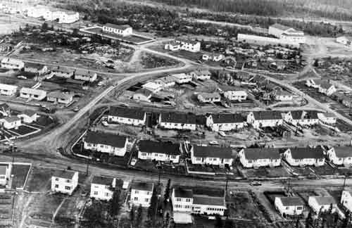
Aerial view of Snow Lake, Manitoba, 1960.
Source: Archives of ManitobaThe construction of the Leaf Rapids town site began in August of 1971. Due largely to the replanning of the town site and then compounded by weather problems and transportation difficulties, the construction stage was a prolonged and drawn-out affair. Indeed the temporary facilities erected for construction staff formed the basis of the community until well into 1972. By the summer of 1972 with the completion of the townhouse complex, the apartment building and over one hundred of the single family units, the town site began to conform to its final configuration. [101] In the course of three years with the project nearing completion, the town site gave evidence of becoming a thriving community. Accommodating in excess of 2,400 people, Leaf Rapids was well on its way to its projected size and configuration.
In conclusion one may say that the Manitoba resource town phenomenon has slowly evolved from the frontier camps of the pre-1930s to the government orchestrated model towns of the 1970s. Generally, while differing approaches to resource town development are revealed from community to community, the common thread is the increasing participation of government in town site affairs. Enhanced by the greater northern focus of government policy in the post-World War II period, eventually, the provincial government came to dictate the terms of resource town development.
The pre-1930 era of resource town development was a period of company dominance. Although the majority of communities were of the camp style, the Pine Falls experience would suggest that certain companies and/or individuals did indeed attempt to plan community facilities. The planning initiative however was almost entirely the responsibility of the resource development firm. The ad hoc incorporation of design and building schedules echoed the tentative nature of the resource production process.
With the transfer of natural resources the circumstance of community development changed, but only marginally. As is seen at both Sherridon and Flin Flon, the resource companies retained control of community affairs regardless of government structure or policy. In general, however, the provincial government appeared to be more willing to accommodate the resource companies than had the federal government.
The final era, the post World War II phase, witnessed a phenomenal expansion of the resource sector and the greater responsibility for planning accepted by government. A variety of schemes and programs to coordinate resource town development were implemented. Ranging from the Local Government District Act to the Leaf Rapids Development Corporation, these programs suggest that the provincial government more and more willingly participated in the resource town experience. The development of the resource frontier had in fact become a publicly controlled endeavour.
Notes
1. G. A. Stelter and A. F. J. Artibise, “Canadian Resource Towns in Historical Perspective,” Plan Canada 18 (March 1978), p. 7.
2. L. D. McCann, “Canadian Resource Towns: A Heartland Hinter-land Perspective,” in R. Preston and L. Russwurn, Essays in Canadian Urban Process and Form (Waterloo: University of Waterloo, Department of Geography Publications, Series No. 15, 1980), p. 213.
3. G. A. Stelter, “The Urban Frontier in Canadian History,” in A. R. McCormack and I. Macpherson (eds.), Cities in the West (Ottawa: National Museum of Man, 1975), pp. 270-286.
5. D. Baldwin, “Invitation vs. Innovation: Cobalt as an Urban Frontier Town,” Laurentian University Review, XI (February 1979), p. 24.
6. See: G. Tough, “Mining in the Canadian North,” in W. Wonders (ed.), The North: Studies in Canadian Geography (Toronto: University of Toronto Press, 1972), and L. D. McCann, “Canadian Resource Towns.”
7. L. D. McCann, “Canadian Resource Towns,” p. 238.
8. R. J. Minton, Golden Memories of Bissett (Pinawa: R. J. Minton, 1982), p. 9.
9. This refers to the boom and bust cycles experienced in many single industry towns. In Bissett a series of boom and bust occurred from approximately 1934-1962. The final bust eventually forced the San Antonio Gold Mining Company into receivership in 1968.
10. Minton, Golden Memories of Bissett, pp. 9-11.
11. J. P. de Wet, “The San Antonio Gold Mine, Manitoba,” The Precambrian, XV (June 1942), p. 3.
12. Minton, Golden Memories of Bissett, pp. 9-11.
13. Provincial Archives of Manitoba (hereafter P.A.M.), San Antonio Gold Mines Collection, MG 11 D2, “The San Antonio Mine and Mill,” dated November, 1935, p. 1.
14. PAM, San Antonio Gold Mines Collection, p. 1.
15. J. P. Mertz, “The Planning of Pine Falls, Manitoba: A Model Industrial Town,” Journal of the Town Planning Institutes (June 1929), p. 47.
19. See for example, E. Howard, Garden Cities of Tomorrow (London: Faber and Faber, 1902), p. 26.
20. Mertz, “Planning of Pine Falls,” p. 48.
21. Single Enterprise Communities in Canada, A Report Prepared for Central Mortgage and Housing Corporation by the Institute of Local Government (Kingston: Queen’s University, 1953), p. 210.
22. J. P. Mertz, “Planning of Pine Falls,” p. 48.
24. Canada, Royal Commission on the Transfer of the National Resources of Manitoba, Report, 1929, File No. 3, p. 4.
26. Flin Flon Daily Miner, 23 August 1962.
27. V. Hedman, L. Yauck and J. Henerson, Flin Flon (Altona: Flin Flon Historical Society, 1974), p. 76.
28. W. E. Hobbs, “Planning New Towns in Northern Manitoba,” Journal of the Town Planning Institute (October 1929), p. 78.
30. The Northern Mail, 24 April 1929.
31. W. E. Hobbs, “Planning New Towns.”
32. Single Enterprise Communities in Canada, p. 9.
33. W. F. Clarke, “Leaf Rapids Development,” The Canadian Mining and Metallurgical Bulletin 68 (April 1975), p. 84.
34. PAM, Ministry of Natural Resources Collection, RG 17, Series
B, Box 103, File 42-1-1, “Sherridon Town Planning Scheme.”
35. C. R. Neely, “Managing The Town of Sherridon,” Precambrian XIII (March 1940), p. 17.
38. G. Cole, Flin Flon Mine (Ottawa: Department of Mines Publication, 1938), p. 3.
39. Hedman et al., Flin Flon, p. 74.
40. PAM, Field Notes of Township 67, Range 29W, Survey of Proposed Town site of Hudson Bay Mining and Smelting Company Ltd. by J. Waldron, March 14-April 22, 1928.
41. The Pas Herald and Mining News, 1 February 1929.
42. The Northern Mail, 24 April 1931.
43. Flin Flon Miner, 2 April 1931.
45. Minutes of the Responsible Authority/ for the Flin Flon Town Planning Scheme, 1932.
46. The CDC was to be composed of three representatives from each of the provincial government, the mining company and the community. The provincial government, however, feeling that the community would be adequately administered under the Provincial Town Planning Commission which was responsible for the supervision of the scheme, revoked its right to appoint three Commissioners. In their place, the HBM&S appointed two more representatives.
47. Flin Flon Miner, 22 October 1931.
48. Statutes of Manitoba, 1944, 8 Geo. VI, C. 59.
49. Statutes of Manitoba, 1945, 9 Geo. VI, C. 82.
50. Statutes of Manitoba, 1945, 9 Geo. VI, C. 82, Part II.
51. J. P. de Wet, “Snow Lake, Manitoba,” Precambrian XXIV (March 1951), p. 15.
57. The Winnipeg Tribune, 19 March 1947.
60. Winnipeg Free Press, 17 January 1952.
65. J. B. Nickels, D. L. Sexton and C. A. Bayer, Life Satisfaction in a Resource Frontier Community, Series 2, No. 27 (Winnipeg: University of Manitoba 1976), pp. 21-22.
66. “New Town in Manitoba,” Industrial Canada, (October 1959), p. 48.
67. G. R. Morris, “A Study of the Design Determinants of Five Canadian New Towns” (M.C.P. thesis, University of Manitoba, 1968), p. 58.
68. D. G. Henderson, “Community Planning of the town site of Thompson,” The Canadian Mining and Metallurgical Bulletin LXVII (1964), p. 1193.
69. This refers to Inco activity at Lively, Ontario, which seemingly dissuaded the company from establishing a company town.
70. W. Troyer, “Thompson, Manitoba-Company Town 1961 Style,” Saturday Night, 76 (1 April 1961) p. 10.
71. D. G. Henderson, “Community Planning of Thompson,” p. 1193.
73. N. Anderson, “Inco’s Thompson Town,” The Financial Post CIV (10 September 1960), p. 25.
74. D. G. Henderson, “Community Planning of Thompson,” p. 1193.
79. N. Anderson, “Inco’s Thompson Town,” p. 25.
80. S. H. Dietze, The Physical Development of Remote Resource Towns (Ottawa: Central Mortgage and Housing Corporation, 1968), p. 27.
89. D. Clunie, “Two New Northern Communities,” Contact 8 (August 1976), p. 312.
90. W. F. Clarke, “Leaf Rapids Development,” p. 86.
94. D. Clunie, “Two New Northern Communities, p. 31.2.
95. H. D. Linn and J. C. Stabler, Economic, Social and Planning Requirements for Northern Connnunities (Regina: Department of Mineral Resources, 1978), 5-1-5-2.
96. W. F. Clarke, “Leaf Rapids Development,” p. 86.
97. H. D. Linn and J. C. Stabler, Economic, Social and Planning Requirements, pp. 5-14.
98. Of particular note in this regard is the Hallmark Hornepayne Center in Hornepayne, Ontario. For details see: O. Saarinen, “Single Sector Communities in Northern Ontario: Historical Perspectives: (Paper Presented at the Canadian-American Urban Development Conference, University of Guelph, Guelph, Ontario, 24-28 August 1982), pp. 43-45.
99. W. F. Clarke, “Leaf Rapids Development,” p. 88.
100. H. D. Linn and J. C. Stabler, Economic, Social and Planning Requirements, pp. 5-4.
101. D. R. Grimes, “Leaf Rapids Planning and Construction,” The Canadian Mining and Metallurgical Bulletin 68 (April 1975), p. 90.
Page revised: 29 October 2018