by George Bryce, LL.D.
MHS Transactions, Series 1, No. 41
Read 22 January 1891
|
The lecture by Rev. Dr. Bryce before the Historical and Scientific Society Thursday attracted a large audience to the City hall. The chair was taken by Rev. A. B. Baird, and when the meeting was called to order, Rev. Dr. Bryce began his lecture on "Old Lake Agassiz," and the surface geology of the Red River and Assiniboine valleys, speaking as follows:
In the summer of 1887 there called upon the writer, in Winnipeg, a studious looking young man, whose address was given as Mr. Warren Upham, Somerville, Massachusetts. Mr. Upham said that with a companion he was engaged in examining and measuring the various ridges that on the slopes of Pembina Mountains, Tiger Hills and Riding Mountain are found so abundantly, rising one above the other. Mr. Upham explained the object of his visit, and said that the Minnesota geologists had been examining these ridges as far back as 1879, and that indeed Major Keating as long ago as 1823 had called attention to these marked surface features. The study of Mr. Upham and others including our own Canadian geologists has led to the unravelling of the mystery of our prairies and to-day we have reached geologic certainty on almost all essential points as to their formation.
As well known even to the tyro, the rocks underlying the soil or drift deposit of Manitoba and the Territories are largely limestone and sandstones deposited ages ago. These were formed by the action of climate and water agencies, wearing down the rocks of the great Laurentian belt lying to the east of us in Keewatin and Northwest Ontario. Raised above the water, these rocks, chiefly limestone as found at Selkirk, Stonewall, and generally under our prairies, remained exposed to the action of the weather, and no doubt became honeycombed and loose, and easily removed for a considerable depth. We estimate that one hundred feet or more of this fragile rock thus removed lay over the site of Winnipeg. At length changes in the earth's climate took place, so that while at the time of the formation of these Silurian rocks there had been a high temperature and warm seas in which grew vast colonies of coral, in this later time following the upheaval of the Rocky mountains, there came a period of great cold. It is not our work this evening to speak of the causes of this change, which took place in what is generally known as the glacier period, but simply to note the undoubted fact.
The beginning of this period of cold was probably not less than from 150,000 to 200,000 years ago. Gradually the land sloping then as now, to Hudson Bay, became covered with snow, and this became too heavy for the sun to melt, and thus rose great beds of ice such as we see in the bosom of the Rocky mountain valleys to day. Century after century the ice built higher, and extended further south. It is believed that at some points there was a depth of from 6,000 to 10,000 feet of ice, and we know that the icy sway was continued as far south as the latitude 39° N , or nearly to St. Louis, at the mouth of the Missouri river. At length came a time when internal changes of the earth's crust banished the reign of winter for a while from much of this region, but again a second glacial period visited the earth, and the ice in great fields was a second time piled up. The departure of this second vast ice field is what left the surface of our prairies in their present condition; and the beginning of this latter period has been estimated at from 5,000 to 7,000 years ago. Mr. Upham's surmise is that the removal of the ice from the south of the Red river valley down to Hudson Bay may have been done in perhaps one thousand years. Others speak of longer time.
Some 250 miles south of Winnipeg, on the western boundary of Minnesota, a valley is seen 125 to 150 feet deep, with a width of about a mile and a half. This connects the valley of the Red river with that of the Mississippi, and here the drift of the water shed was cut through by a great river. The valley has been partly filled up again by tributary streams, but in the south end of it is Big Stone lake emptying into the Minnesota river, a tributary of the Mississippi, and in the north of it Lake Traverse running into the upper branch of the Red river. When the ice of the glacial period reached this point in its withdrawal there was no valley, but a lake began to form north of the height of land and bounded by the lobe of the glacier. Still further north the glacier retreated and formed an ever enlarging sheet fresh water, which at length found for the time being its outlet southward down the cannel described, and deposited from the grinding up of the old Silurian limestones, and also of the hard Laurentian rocks of the east, the drift clay and the boulders in its east moraines. It is to this wide sheet of water that in memory of the late Prof. Louis Agassiz, the first great upholder of the theory "that the drift was produced by land ice," the name has been given of the glacial "Lake Agassiz."
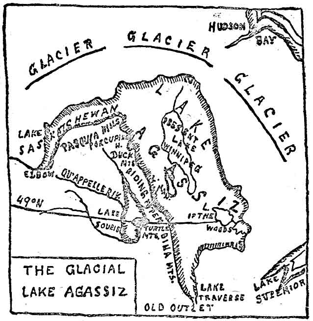
Figure 1 gives the limits of the ancient lake at its greatest extent, and it will be seen that Lakes Winnipeg, Manitoba and Winnipegosis now occupy the bottom of the basin which was then of so great size. At the time when this wide expanse was pouring its waters down the Mississippi valley the depth of the lake where Winnipeg now stands was about 500 feet, and the waters laved a coastline high up the steep of Pembina Mountains, Tiger Hills and Riding Mountains to the west. To the east Lake Agassiz extended including the present Lake of the Woods, and spread even to the height of land bounding Rainy Lake. The northern limit was the great ice barrier itself, which was from year to year and century to century slowly receding. While the surplus waters were thus pouring from the southern outlet this place of exit was being gradually deepened, and thus standing for a few years at one level along the coast line one beach was outlined, and then as it receded another at the lower level was formed, and so on. At the same time in the period of highest water there seems to have been a gradual elevation of the coast line as well, arising from inner motions of the earth's crust, and from other causes. No less than seventeen beaches have been braced in Manitoba, formed during the time when Lake Agassiz was emptying southward. We have not time to name and describe all of these, but may notice one or two of the most remarkable. At the time when Lake Agassiz formed its first beach, its outlet was 85 feet above the present surface of Lake Traverse, or 1,055 feet above the sea, and its channel was cut through the height of laud about 50 feet deep. The beach has been called by Mr. Upham the Herman beach. It is divided into several levels in Manitoba, but at one point its greatest height is attained on the road over Pembina Mountain between Morden and Thornhill in Southern Manitoba where it is 1,255 feet above the sea. The second division of this highest or Herman beach is found on Tiger Hills about one mile south of the village of Treherne, and again appears in the well marked sand and gravel ridge one eighth of a mile north of the court house in the city of Brandon, while the same beach is seen some three miles west of the town of Neepawa. Thus from this winding coast line eastward extended the waters of the ice cold lake held in along the northern side by the great glacier mass itself (fig. 1). The next lower beach formed when the waters of the lake had lowered about 25 feet, no doubt by the cutting down of the outlet at Lake Traverse. This is known as the Norcross beach; and so we might give the elevations and features of the fifteen other beaches whose existence as terraces on the slope of Pembina Mountains has been often pointed out to the writer by the farmers in the several western regions.
One of the most remarkable features of the upper beaches of Lake Agassiz is the gradual ascent in the level of each beach. It is plain that if the lake theory of the formation of these beaches is correct, each beach should have the same normal level. But if raising a horizontal bar painting north and south, greater upward pressure is exerted at the north end than at the other, the bar will slant upwards toward the north. Some earth pressure seems thus to have raised the north end of these beaches. In the highest or Herman beach it is found that taking its level at Lake Traverse, when Lake Agassiz emptied there, the beach line was from 1055 to 1045 feet above the sea, while at the international boundary line a point 224 miles further north, it was actually 1230 feet above the sea or 175 feet higher. But this elevating tendency in the north was very far from being a constant or steady rise. In the stages of the Herman beach toward its northern limit the elevation varied so that four fairly well marked stages of the Herman beach are traceable. Thus while the Herman beach only differed at the outlet of the lake between 1055 to 1045 feet above the sea, its lowest stage was 1175 feet above the sea at the international line i.e. 130 feet above the outlet level. Ten feet thus marks the variation at the outlet while no less than 45 feet is the difference caused by the northern elevation at the boundary line.
There has been much discussion as to the causes of this upward motion in the northern end of Lake Agassiz. Probably no one cause entirely accounts for this. The following are the agencies suggested:
(1) The tendency shown by Mr. R. S. Woodward, of the U.S. Geological Survey, of the waters of a glacial lake to gravitate toward the ice sheet. In the case before us the ice sheet probably extended for 1000 miles north and north-eastward, and being from 1½ to 2 miles in depth would have an enormous attractive power. This would raise the waters of the northern end of the lake, and in this way perhaps one quarter of the elevation that took place in the northern beach levels is accounted for:
(2) The re-elevation of the land as the ice belt receded to the north. The pressure from one to two miles depth of ice would be so great, that according to some geologists a considerable sinking in the underlying earths crust must take place, and then as the glacier males melted the re-elevation of the depressed crust would result.
(3) At this period in the history of our earth there were great oscillations taking place in the earth's crust. These were entirely independent of glacial forces, and if it is found that in other parts of the earth's surface independent crustal movements were going on at this time it will afford an additional explanation of the rise toward the north of these remarkable beaches.
But while the great northern glacier was thus withdrawing and giving its waters to Lake Agassiz, to the west of it, beyond the barriers which held it in, other areas were being formed. As seen in fig. 1, an arm of Lake Agassiz ran up the Saskatchewan valley as far as the Elbow. Into the west of this, which is called the glacial Lake Saskatchewan ran the North Saskatchewan River, and into the southern end the South Saskatchewan. The Pasquia hills were the southern barrier for the lake.
West of Turtle Mountain, which is found in fig. 1 on the international boundary and the Tiger Hills, was the glacial Lake Souris, also represented in fig. 1. From the south-west into this emptied what is now the upper part of the Souris River. Into the northern arm of this Lake Souris poured the upper part of the Assiniboine River, while into the west side flowed the mighty river that came down the Qu'Appelle valley. This Qu'Appelle River was at that time running out of the southern end of Lake Saskatchewan from the point we now call the Elbow, down the easily traced channel that leads into the great valley with its overhanging heights, the wonder of all visitors to the Qu'Appelle. Lake Souris had on our side of the boundary line effluents carrying its waters into Lake Agassiz. These were the Pembina river, which ran down the great gorges now so easily traced from the elbow of the Souris river, through Lang's valley, Pelican lake, Rock lake and Swan lake to the crest of Pembina mountains, where it emptied into Lake Agassiz. At a later period, at a point farther north, the Assiniboine river drained, as we shall see, Lake Souris into Lake Agassiz.
At length as the great ice belt receded to the north, the escaping waters ceased to find their way into Lake Traverse and the Mississippi. Northward channels to the sea of Hudson Bay were being found, though not those now followed by the Nelson river and its tributaries. During this northward flow, beaches continued to form on the shores of the lake as it sank from stage to stage. There are eleven of these that can be clearly traced in our territory.
We may follow the course of one or two of these beaches by way of illustration, and thus be able to see the diminishing area of Lake Agassiz. One of them called the Gladstone beach crosses the International boundary line one and a half miles west of the Mennonite village of Blumenort, is again seen a mile east of Carman, crosses the C.P.R. near the Rat Creek bridge west of Burnside, and is trailed half a mile east of Gladstone, being here found to measure 868 feet above the sea. Another notable ridge is that called the Stonewall beach. The main street of Stonewall crosses this beach. The sand and gravel at this point are only ten feet deep above the underlying limestone, which here rises in a swell above the surrounding country. Mr. Upham says:
"Lake Agassiz, at the time of the Stone-wall beach formation, probably extended on the fiat Red river valley to a distance of about twenty-five miles south of the international boundary, being some fifteen feet deep at Emerson and Pembina, while over the site of Winnipeg its depth was about sixty feet."
The Morris beach is found about ore mile east of this town, which is forty miles south of Winnipeg, crosses northwest to Starbuck, then northeast to Little Stony Mountain, passes between Stonewall and Stony Mountain, and then north along the west side of Lake Winnipeg a few miles from it.
When Lake Agassiz was in its higher stages the rivers running out of Lake Souris as shown in map 1, emptied the waters of the latter lake into the former. And just as we see Red River at the present time carrying its clayey sediment to slack water at Lake Winnipeg and depositing it in a delta, or as on Lake of the Woods the Rainy river brings down vast quantities of sand, which have been spread over the bottom of the southern half of the lake, and have formed along the shore thirteen miles of great sand hills or dunes, so the ancient tributaries of Lake Agassiz formed in the region of Manitoba two great deltas. To these we owe the sandy deposits along the boundary line made in the slope of the Pembina Mountains and the very marked feature of the country known as the sand bills west and south of Portage la Prairie.
Lake Souris, as mentioned, originally emptied its waters down Lang's valley and through several enlargements, and tumbling over the Pembina mountain the waters deposited their sandy freight in a delta extending twelve miles from north to south, and seven from east to west, to a depth of 200 feet. This lies mostly to the south of the Pembina river valley, as it is seen at present. The material of the delta is mostly sand and gravel, the gravel being chiefly limestone, but much of it is Cretaceous shale and of granitic and gneissic origin. The formation of tie delta seems to have been very rapid and it must have accumulated in sand dunes fifty feet above the surface of Lake Agassiz. But soon the ice sheet receded and allowed Lake Souris to empty itself by way of the Assiniboine into Lake Agassiz, when the water ceased to follow Lang's valley and the period of formation of Pembina delta ceased.
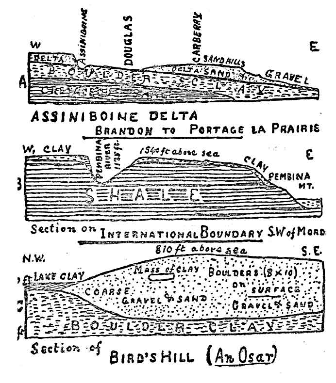
Few travellers on the C.P.R. from Portage la Prairie to Brandon but have noticed the remarkable range of sand bills through which the railway cuts its way. Many speculations have been indulged in as to their origin and construction. Our glacial Lake Agassiz explains it all, and we learn that the Carberry sand dunes are the old delta of the Assiniboine river (Fig 2 A) as it poured forth from Lake Souris and emptied near the site of the present city of Brandon into the waters of the great lake. This delta is of much greater size than that of the Pembina river and was rather later in formation.
The sand and gravel of this great delta extend seventy-five miles east from the old shore of Lake Agassiz to where now stands Portage la Prairie, northeastward fifty miles to Gladstone, and southeastward, for eighty wiles reaching to within nine miles of Carman. When this wide extent of delta material was carried down by the Assiniboine it was deposited on the lake bottom and rose in many places in shoals and low islands above the surface of the lake. The appearance of the sand hills near Glenboro and Cypress is very striking. This delta represents a vast amount of erosive power on the part of the glacial streams and it has been calculated that the amount of material thus brought down is equal to twenty cubic miles.
The present valley of the Assiniboine is a deep cut through its own old delta, and made after the waters of Lake Agassiz had receded towards their present limits. The force with which the river fell into Lake Agassiz seems to have prevented the deposition of sand and gravel until the station of Douglas, on the C.P.R is reached, a distance of twelve miles or more from the shoreline, where the soil consists of boulder clay; or it is possible that part of the overlying sand of the delta may have here been cleared away by the river as It cut out its later channel. That it has gone on sinking its channel deeper and deeper, until the river runs in a valley 200 to 300 feet in depth is a very noticeable fact. The sands of the old delta have become the plaything of the elements. The fine sand driven about by every wind has assumed the form of dunes from 10 to 75 feet high, either covered with bushes and a few characteristic plants, or too barren to grow even sedges.
West of Brandon new conditions obtain. After passing the upper end of the delta of Lake Agassiz, another series of delta deposits are reached near Griswold and thence westward, which represent a delta of the old Lake Souris into which the Upper Assiniboine fell. The geology of this region is rather difficult, as valleys are met with through which as the levels changed the waters flowed westward and afterwards east ward. Suffice it to say that this delta was remorselessly hollowed out and eroded by the voracious Assiniboine, which in this case as in that of the Lake Agassiz delta, like the old Saturn of the myths devoured its own children, and now runs with rapid current bordered for no less than 120 miles by the sand hills originally formed by Its own waters.
It but remains to state a little more fully the theory we have assumed as to the formation of our drift deposits. It will be noticed we have postulated a vast field of land ice of great depth, extending all over the north of this continent, even from Labrador to the Rocky mountains. It is just to state that this theory is not held by all. Sir William Dawson, in his "Handbook of Geology," published quite recently, advances the iceberg theory by which to explain our wide prairie drift deposits. He says: "There does not seem to be any evidence necessitating the supposition of a great northern ice cap or its southward progress." He admits, however, that "the glaciating agent of the Laurentian plateau in the Lake of the Woods region cannot have been other than glacier ice;" and further that there are difficulties yet unaccounted for by the theory of glaciation and deposit of drift on the plains by icebergs." Now to all this we have to say that the thorough measurement and examination of the country by Mr. Upham and other observers, and the satisfactory explanation of the chief phenomena seem to justify our thorough acceptance of the glacier hypothesis.
When the great ice cap extending far south near the mouth of the Missouri began to melt it receded in lobes. The mass of northern ice kept a steady pressure southward. As the ice receded great masses of ground up rock were spread around the glacier lobes. The honeycombed and broken surfaces of Laurentian, Silurian and Cretaceous rocks were crushed to powder, or became sand or gravel; gushing out from beneath the glacier the muddy stream carried southward its load and deposited it in the slack water of lakes; along the edges of the retreating ice lobe vast ridges called moraines were formed as we see in any glacier in the Rockies, or Selkirks, or the Alps at the present day. And these formed the barriers containing lakes which resulted from the melting ice. The directionof these great ridges with a general north to south trend shows this to have been the case, though there are exceptions. The great Missouri Coteau is the terminal moraine of the western glacier as it receded northward. The Tiger Hills, Riding Mountains, Brandon Hills, Arrow Hills and the lake are east moraines.
One of the memorials of this glacial formation remains to us in Stony Mountain northwest of Winnipeg. There rising 80 feet above the prairie is a mass of solid Silurian limestone. It used to be a puzzle to us to make out whether this was an enormous drift boulder or was a mass of the old Silurian bed in situ. Observations of late years to the east on Lake of the Woods and Lake Winnipeg have given us hundreds of cases of glacial striae running from N.E to S.W. showing that the course of the glacier was in that direction. But to the west of Stony Mountain the strive are seen abundantly at Stonewall and are all from N.W. to S.E. We accordingly reason that while the tremendous glacier force was ploughing out and grinding up the rock surface and forming the material of our fertile soil the two forces met south of Stony Mountain, and left the mountain north of the point of impingement, as an archaeological monument of the glacial era. The gradual way in which the ground up material was spread by lake currents over the surface of the underlying rock is shown in Fig. 2 B. where a layer of boulder clay is seen covering the shale of which Pembina Mt. is composed.
The origin of Bird's Hill, a few miles northeast of Winnipeg, was an object of considerable speculation even to the old settlers. Its structure has been laid bare by the great excavations in it made by the Canadian Pacific and we are now able to make out its origin. It consists of a hill from one quarter to half a mile wide, and its crest is from 805 to 510 feet above the sea. The ridges of this great formation run in lines of gravel and sand from northwest to southeast; the hill called by the old settlers Oak Hummock to the south is a part of the same formation, whilst the prominent eminence called Moose Nose is but a continuation of it. Mr. Upham's explanation is that this whole group of elevations is composed of gravel and sand, irregularly bedded (See Fig. 2 B), which appear to be deposits formed near the mouths of glacial rivers when they flowed between walls of ice and were here and there divided by ice islands. When the ice about and beneath melted, then the deposits sank to the bottom of Lake Agassiz here about five hundred feet deep. Formations such as this are known to geologists as "Osars." On the northern slope of Bird's Hill numerous granite and gneissic boulders are found, but few or none on its southern slope. Osars of this kind are found to the northwest of Winnipeg, in what was known to the old settlers as Grosse Isle, and in that not very far from it called by the later settlers Burns's Ridge. These likewise are covered with boulders which became stranded from icebergs detached from the glacier lobe and floating southward over the surface of the lake.
An important question is raised as to whether human beings were living on this continent during the glacial period. At the meeting of the American Association for the Advancement of Science, in Toronto in 1889, Prof. Gilbert stated that high up in the beaches of Lake Ontario, where the formation evidently belonged to the glacial period, remains of man in fire circles, burnt stones and the like were discernible in the gravels. In the records of the society for the same year is an article by Miss Franc C. Babbit, of Michigan, stating that she had found buried in a gravel deposit at Little Falls, in Minnesota, a collection of quartz implements, not water worn and seemingly laid on the surface, at the time dry. These it is maintained by Miss Babbit must have been deposited at the time of the eighth beach in the formation of Lake Agassiz, and of course would seem to indicate the presence of man at that time. Dr. Winchell and the other geologists of Minnesota seem to agree in Miss Babbit's conclusion. The authority is also quoted of a young Canadian geologist, Mr. J. B. Tyrrell, well known to us in this city, to the effect that in northwestern Manitoba at an elevation of 1,135 feet above the sea he has found sharp edged fragments of quartzite, chipped by human workmanship, inter bedded with the rounded gravel of one of our Lake Agassiz beaches. We shall await with greatest interest evidence tending to show the presence of man so many thousand years ago at the foot of the receding glaciers.
We have thus met most of the problems of our surface geology. It is by thought and discussion that we reach the truth in such matters. To my own mind the glacier theory of a drift seems absolutely conclusive, though it is possible our applications of it to explain certain phenomena may need further modification. I have to express my indebtedness to our Canadian geologists, but especially to Mr. Warren Upham, for working out so completely our surface geology, the antecedent of the present state of things. We are wonderstruck at the magnitude of the forces which brought this about and say with Dr. Geikie: "Thus as imperceptibly as it began the long and varied ice age came to an end as it merged into the present geological period."
At the conclusion of the lecture a vote of thanks was tendered Dr. Bryce for the same, on motion of Rev. Prof. Hart, seconded by U.S. Consul Taylor. Interesting remarks on the theory and facts presented were made by the mover and seconder, and also by Messrs. W. G Fonseca, Dr. Laird of Wesley College, Mr. F. H. Turnock and others; and the lecturer kindly answered several questions proposed.
* The author is much indebted in this paper to Mr. Warren Upham, the American geologist, in his private conversations, his published brochures, and his Report on Glacial Lake Agassiz published by the Canadian Geological Survey, 1890.
Page revised: 22 May 2010