Chapter 8: Southern Hamlets, Villages, and Towns
Two factors—railway lines and the DLS system— influence the location and form of settlements in southern The arrangement can produce a road orientation that is at an angle to the squares of the DLS (e.g. Hartney and Dauphin). Other settlements have a road system that harmonizes with the DLS into which the urban pattern is slotted, with roads trending north/south and east/west (e.g.
8.1: Coulter
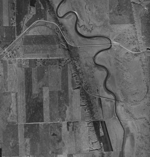
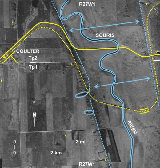
The small hamlet of Coulter in the southwestern corner of The Souris River 5 flows northward on the flat floor of a steep-sided spillway 6. The large southward loop by the railway line 7 seems anomalous, but it exists so that the railway can run obliquely down/up the spillway sides 8 avoiding steep gradients. The road—PR 251 9—is more tolerant of steep slopes, but even so it runs obliquely across the west bank of the spillway 10 before passing north of Coulter. Other features of note in this flat, semi-arid area open to strong winds are: the scarcity of trees except in draws in the spillway banks—especially the west side 11 that faces north of west and therefore has a wetter microclimate than the opposite side; several dugouts 12; four small dams 13 designed to retain water in ephemeral creeks; and barriers along the railway line 14 to retain drifting snow. [[fig. 8.1]]
8.2: Roseisle
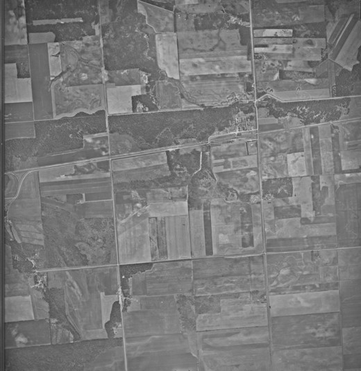
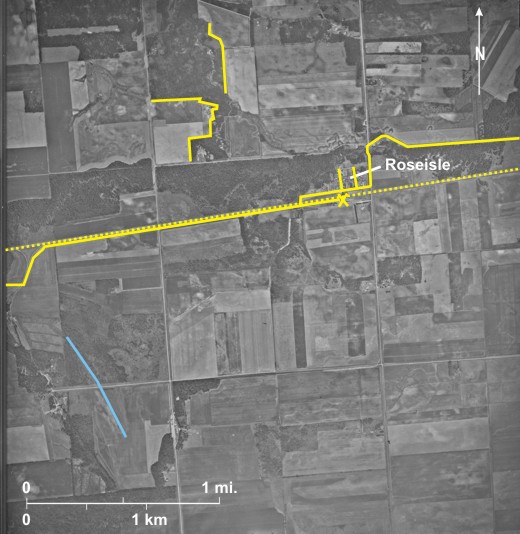
The small hamlet of Roseisle is located at the foot of The CN line runs west-southwest/east-northeast across the area 3 with an elevator on a siding at Roseisle 4. In the hamlet that had a population of less than 50 when the photo was taken, a road runs parallel to the line 5 but set back some distance from it. In contrast to Coulter, two roads 6 run at right angles to this road. In 1958 PR 245 passed through Roseisle and continued east 7 and west 8. [[fig. 8.2]]
8.3: Roseisle in 2000
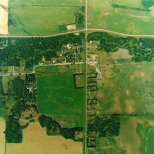
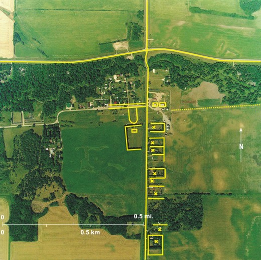
The most obvious difference from 1958 (figure 8.2) is that the railway line has completely disappeared; the only evidence of its former existence is a faint impression in the east 1. Also PR 245 2 in the north has been straightened, and the main street 3 of the hamlet is slightly wider. Two narrow roads 4 run south from it to a building 5 sheltered by trees 6. Also at least 8 houses 7 sheltered by trees 8 have been built east of PR 240 9. Two large buildings—light-toned—at the east end of the main street 10 may house curling and/or hockey rinks. These were not present in 1958.
[[fig. 8.3]]
8.4: Snowflake
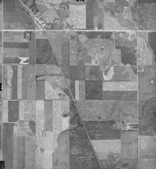
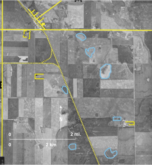
Snowflake is located in southern As at Roseisle, a road 1 is located parallel to the CN line 2 with—in this case—three roads at right angles 3. The one large building in Snowflake probably houses a hockey rink 4. South of Snowflake the direction of the rail line changes slightly 5 with a branch line leading off to the west 6. PR 201 7 crosses the area east/west, and PR 242 8 runs north/south. Most of the land has been cleared for agriculture with only occasional patches of trees 9 and several infilled sloughs 10. Large shelterbelts protect most of the farms 11 which are widely spaced in this sparsely populated area. [[fig. 8.4]]
8.5: Snowflake in 2000
As was the case with Roseisle, the railway line has gone, leaving behind only faint traces 1 of its former existence. However, two elevators 2—identified by their shadow shape—still remain. There are fewer houses than in figure 8.4, but a second large building, long and narrow 3, has been added in the east; this probably houses a curling rink. North of it is a primitive baseball diamond 4. In the west a grain crop has been partly swathed, resulting in narrow even rows 5.
[[fig. 8.5]]
8.6: Arden
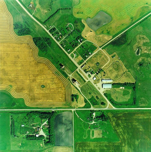
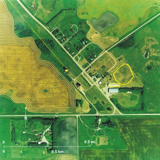
This image of an area about 8 miles (13 km) east-northeast of Neepawa illustrates the influence of even very minor landforms on route ways and settlements in southern Manitoba. At least six
[[fig. 8.6]]
8.7: Napinka
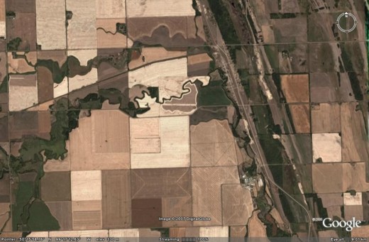
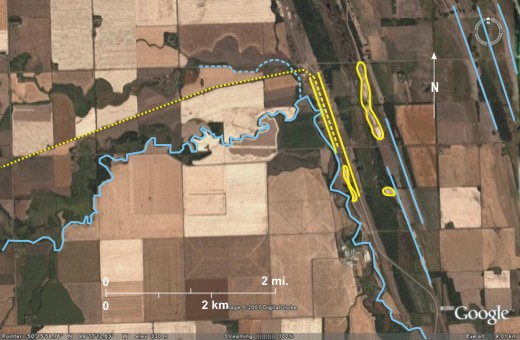
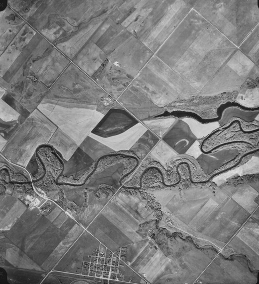
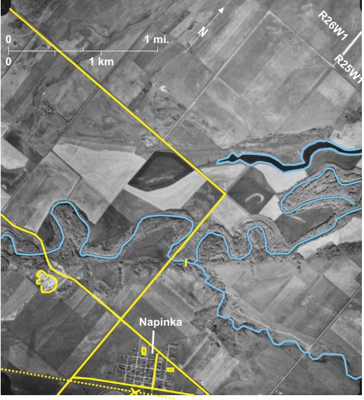
Napinka, located southeast of the Souris River 1 in southwestern
The
8.8: Belmont
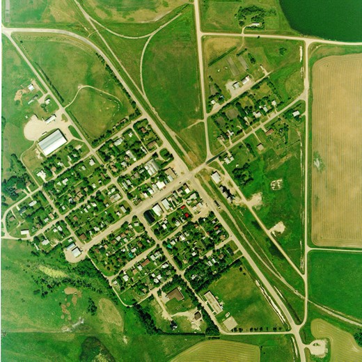
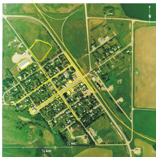
[[fig. 8.8]]
8.9: Rathwell
Rathwell is another small community with a road pattern dictated by the railway line. The CP railway line 1 runs south of the settlement; two elevators 2 and numerous grain storage bins 3 are located on a siding 4. A wide road 5 runs north of, and parallel to, the railway line with another wide road 6—the main street—at right angles to it. Other roads are parallel 7 to or at right angles 8 to the railway line. Several large buildings, probably stores 9, are located on the two wide roads. In the southeast are two long, narrow buildings 10, at least one of which probably houses a curling rink. Houses in the western part of the community are surrounded by tree shelterbelts 11. PTH 2 12, which runs east via St. Claude and Elm Creek to
[[fig. 8.9]]
8.10: Foxwarren
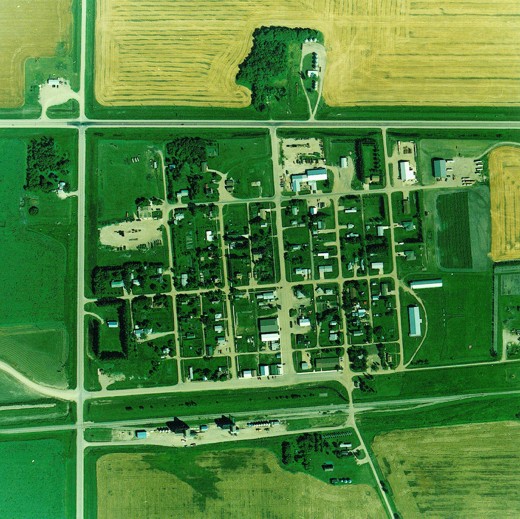
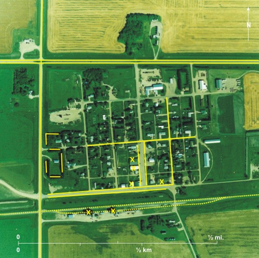
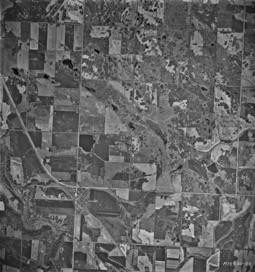
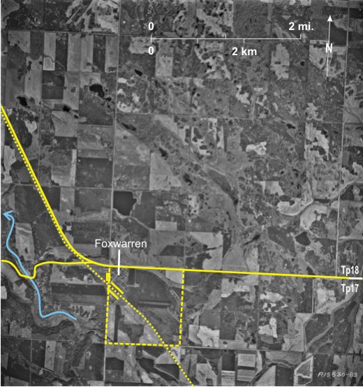
The small settlement of Foxwarren (population 159 in 1986) is another classic example of a railway-oriented village. The CP line 1 passes through it with three elevators 2 on its southwest side. Two roads—one northeast of the line 3 and the other southwest 4—are parallel to the railway. Other roads are parallel and at right angles to the railway line producing a grid at 45 degrees to the section lines of the DLS system 5. As is usually the case with small
Other communication lines are Highway 16—The Yellowhead Route 7—that bypasses Foxwarren to the north and PR 475 8 that deviates from a straight line to cross Snake Creek 9, a north bank tributary of the Assiniboine River (off the photo to the southwest).
[[fig.8.10]]
8.11: Vertical Air Photo of Strathclair
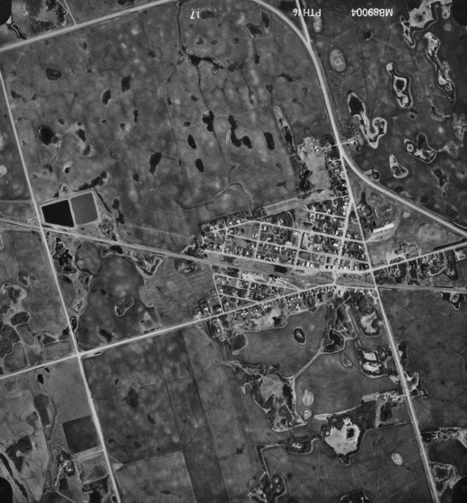
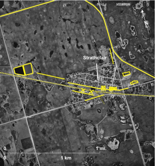
The hamlet of Strathclair, located in an area of typical ground moraine topography, is slightly larger than settlements shown previously (figures 8.1 to 8.10) having a population of 390 in 1986. It is another example of the railway line determining road orientation. Here the CP line 1 runs along the southern edge of the settlement with South Railway Street 2 and North Railway Street 3 parallel to it; the latter even has a slight bend in the east 4 to maintain the parallel arrangement. Other roads are at right angles and parallel to the two Railway Streets. Highway 16—The Yellowhead Route 5—bypasses Strathclair to the north.
Given the large scale of the photo, several large buildings can be observed and some identified. In the east are a rink 6 (hockey and curling) and a school 7 with cars—small oblong objects 8—parked to the south and east. Most of Strathclair is located north of the railway line south of which is an elevator 9. Oil storage cylinders 10 are located northwest of the elevator. Cars are parked obliquely along North Railway Street 11 outside a series of larger buildings 12 which are probably stores. Newer residential areas are along section lines south 13 and north 14 of the hamlet. The large angular areas, one very dark-toned 15 and the other lighter 16 are sewage lagoons with a light-toned line indicating the location of a buried pipeline 17 leading to them.
[[fig. 8.11]]
8.12: Oblique Air Photo of Strathclair
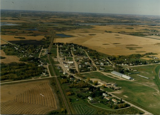
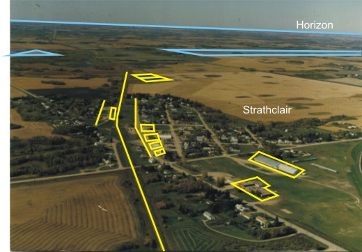
The photograph is taken looking westward with the largest scale in the foreground, decreasing away from the viewer. The photo looks along the CP line 1 with the elevator 2 located south of it and South Railway Street 3 and North Railway Street 4 parallel to it, the latter with a bend 5 to maintain the parallelism. In the foreground are a school 6 and a rink (hockey and curling) 7. Stores are located along North Railway Street 8. The sewage lagoons 9 can be seen in the background with even further away [[fig. 8.12]]
8.13: Elphinstone
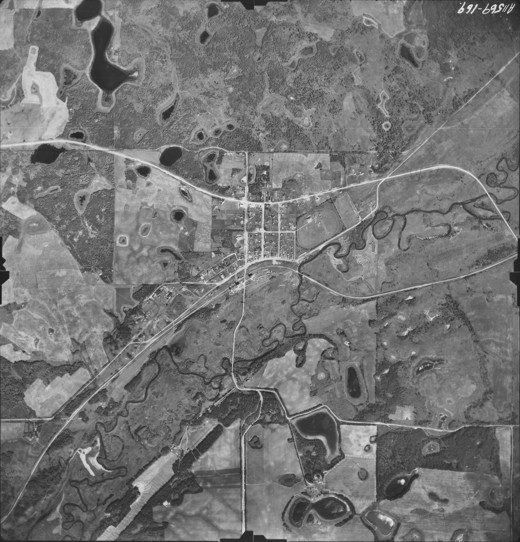
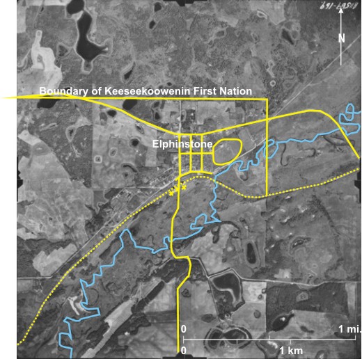
Elphinstone is another hamlet with a road pattern determined by the railway line; but here the CP line 1 follows a curved route to cross the Little Saskatchewan River 2. As a result the road nearest the line is also curved 3 with other roads as near as possible at right angles. Surprisingly for such a small settlement (population 201 in 1986) in an agriculturally marginal area, there are three elevators 4 on the line. East of the settlement is a racetrack 5. North and east of Elphinstone is the Keeseekoowenin First Nation (boundary marked by dashed line). Much of the area is wooded 6. In this topographically complicated area the rigid grid of the DLS breaks down under the influence of the topography. The CP line is curved to follow the Little Saskatchewan River valley. PTH 45 7 is curved, and PR 354 from the south 8 bends as it crosses the Little Saskatchewan River. [[fig. 8.13]]
8.14: Treherne
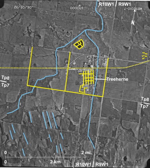
The [[fig. 8.14]]
8.15: Treherne in 2000
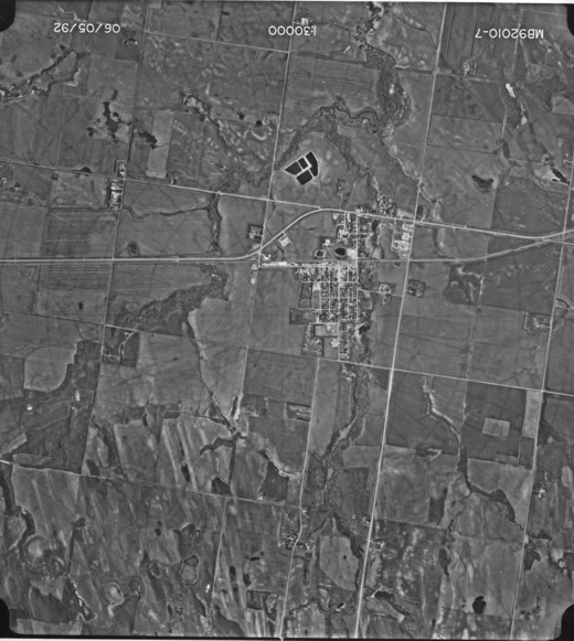
This large-scale colour air photo shows the pattern of roads in Treherne determined by the direction of the CP railway line 1. The village exhibits the classic T-shape of prairie settlements with a road parallel to the railway line 2—the bar of the T—and a road at right angles to that 3—the stem of the T. The latter is the main road of the settlement; it is wider than roads parallel to it and has large buildings 4, probably stores, along it. Cars can be seen 5 parked on this street. Several things can be seen on this photo that are not obvious in Figure 8.14:
1) Vehicles (trucks 6 and cars 7) can be seen on PTH 2 8 that bypasses the village to the north.
2) Two elevators 9, identified by their shadow shape, are located on a siding 10 off the railway line.
3) In the northern part of the village is a large new building 11, possibly a senior citizens’ home or a hospital.
4) In the southwest a field has been cut and partly combined 12.
5) The large building 13 near the centre of the photo is probably a hockey arena.
[[fig. 8.15]]
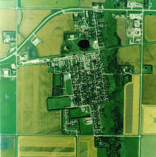
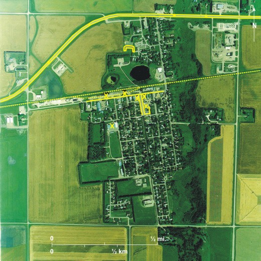
8.16: Hartney
The town of
At the large scale of the photo, individual buildings can be located and identified. As is often the case the most obvious are a rink 10 (ice hockey and curling) in the northeast and a school 11 in the southeast. Sewage lagoons, one dark-toned 12 and one light 13, can be seen in the north.
[[fig.8.16]]
8.17: Rivers
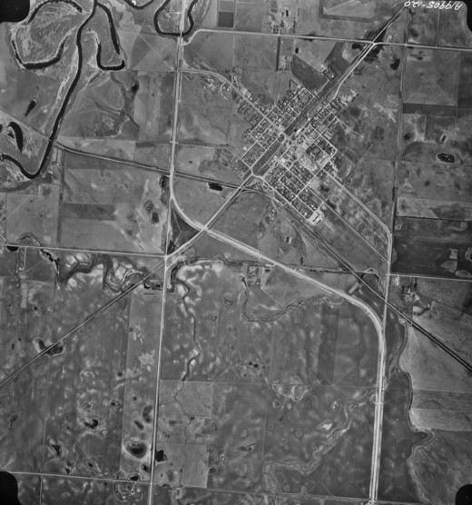
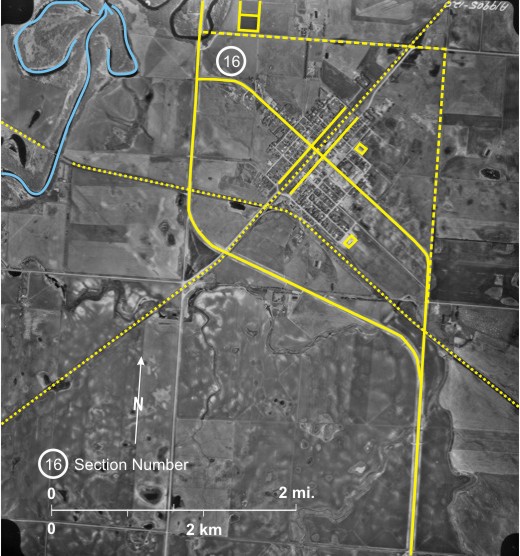
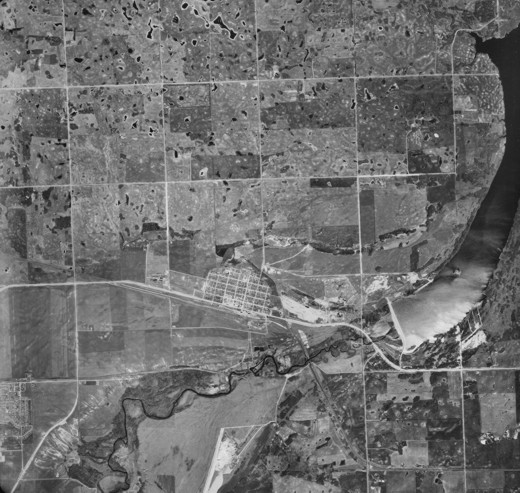
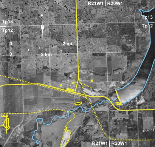
The town of Although the air photo scale is small, some of the town’s infrastructure can be identified. A series of large buildings near the southern edge of town 9 are probably stores and a hotel; schools can be seen in the north 10 and west 11; and sewage lagoons 12 and a cemetery 13 are located outside town. In the southern part of the Little Saskatchewan Valley is an area of outwash deposits 14, identified by remnants of water channels on the surface, with a large light-toned gravel pit 15 served by the CP line. Several other gravel pits 16 are located in the valley. The Little Saskatchewan has been dammed to produce Lake Wahtopanah 17, originally for flood control and water supply, but recently it has attracted some recreational development along its shores 18. Both the dam 19 and a spillway at its south end 20 can be identified. Rivers has had a checkered history. During WW II a Commonwealth Air Force Training Base was located at Rivers airport,[i] just off the photo to the west. It continued as a Canadian Forces Base until the 1960s when it was closed. Various attempts have been made—none of them very successful—to locate industries in the buildings of the base. Some of the buildings that housed people serving at the base can be seen in the southwest corner 21. Atypically, they are arranged along a mixture of straight and curved roads. The closing of the base and the failure of the industries led to a 29 percent drop in population between 1961 and 1996 (from 1,574 to 1,117), but it evened out at 1,119 in 2001 and increased to 1,193 in 2006. The buildings seen in the southwest were houses for troops at the base. Here in this relatively modern development, we finally see roads with curves, almost completely absent from settlements show in figures 8.1 to 8.16.
8.18: Killarney
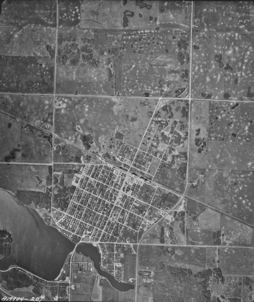
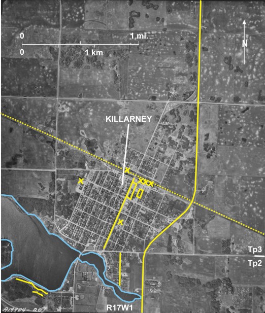
The town of
The large scale of the photo makes it possible to identify individual buildings. Two large buildings, one near the centre of town 9 and one in the west 10, are probably schools, and the large round-topped building east of
Killarney is a relatively prosperous agricultural center. It decreased in size from 2,366 in 1976 to 2,208 in 1996. It showed a modest increase to 2,221 in 2001 but dropped to 2,199 in 2006.
[[fig.8.18]]
8.19: Killarney in 2000
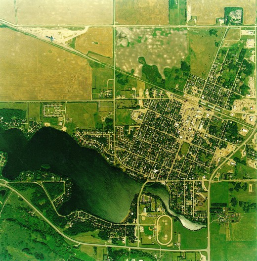
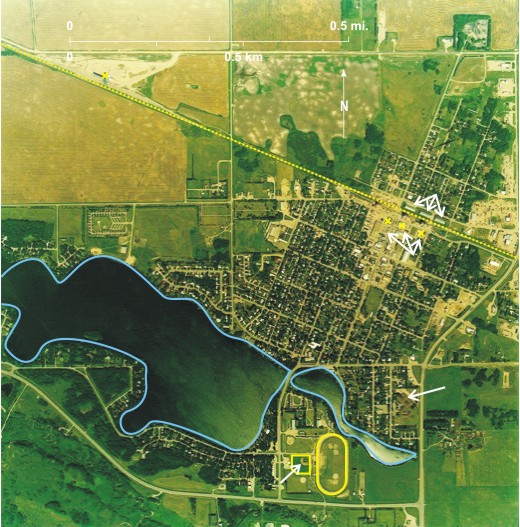
This large-scale colour air photo demonstrates the superiority of colour compared with black and white in illustrating some aspects of the earth’s surface; for example, the concentration of commercial activities near the junction of a road paralleling the railway line and the main street at right angles to it is more apparent than in figure 8.18 1. Also the well-treed nature of the residential areas is very clear 2. Although Killarney is not gaining population, several changes have occurred since 1967 (figure 8.18): 1) There is more extensive house and cottage development on the south shore of the lake 3. 2) A recreational area is now (in 2000) located at the southeast end of the lake; this includes a racetrack 4 and baseball diamond 5. 3) Just to the northeast is a large new building, probably a hospital or a senior citizens home 6. 4) In the east, just north of the railway line, commercial development has occurred; several buildings with many parked cars can be seen 7. 5) One of the four elevators has gone, but three can still be identified on the basis of their shadow shape 8. 6) Three long buildings are now located north of the railway line 9. 7) A large elevator, probably one of the new concrete variety, is now located northwest of town 10. 8) A trailer court is now located north of the lake in what was an open field 11. [[fig. 8.19]]
8.20: Carberry
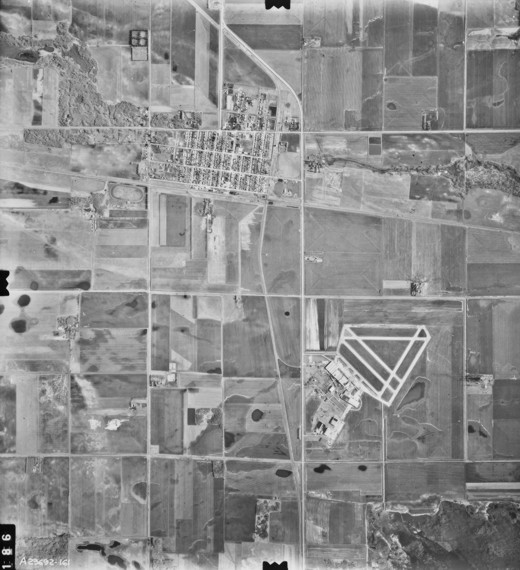
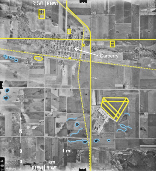
The Town of
The CP line runs generally east/west through the area 3 with the north/south CN line 4 intersecting it at right angles.[i] Elevators are located on both lines 5. Roads in the town run parallel to and at right angles to the railway lines with most of them north of the CP and west of the CN line and at an angle to the DLS grid system. PTH 5 6 bypasses the town to the east and provincial road 351 7 runs through the northern edge of town.
The scale of the photo is smaller than that of figure 8.18. Nonetheless, some items of the town’s infrastructure can be identified: a long building in the north is probably a rink 8, a cemetery is located northwest of town 9, a racing track is to the southwest 10,[ii] and sewage lagoons are to the east 11.
In the south is, or was, Carberry airfield 12 that has the characteristic triangular shape of small prairie airfields.[iii] The field is no longer in use for airplanes but the buildings 13, including some built after the airport was abandoned, are used for processing potatoes. The uniformly textured sandy soils around Carberry, coupled with the availability of ground water for irrigation, make the area ideal for potato growing. The
8.21: Carberry in 2000
This large-scale colour air photo of the eastern part of Carberry shows several aspects of the town better than the black and white photo in figure 8.20, as well as changes that have taken place since that photo was taken (1974):
1) The treed nature of the residential areas, particularly in the west 1, is more obvious.
2) Shelterbelts in the north are easily identified. However, the more northerly of the two 2 did not exist in 1974, and the other one 3 has probably grown a lot in the intervening years.
3) The wide main street 4, with numerous large buildings 5—probably stores—along it is much clearer than on figure 8.20.
4) An enclosed area in the east 6 contains four baseball diamonds 7.
Changes that can be detected are:
1) A connecting spur 8 runs between the CN line and the CP line in the southeast.
2) Another spur line 9 runs southeast from the CP line. Trucks can be seen on this spur 10.
3) Elevators that existed on both the CP line 11 and the CN line 12 have gone.
4) A second long, narrow building 13 has been constructed north of the one in existence in 1974.
5) Another large building 14, possibly a school, has been built south of that mentioned above.
6) Buildings 15 have been constructed east of PTH 5 16.
[[fig. 8.21]]
8.22: Virden
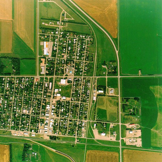
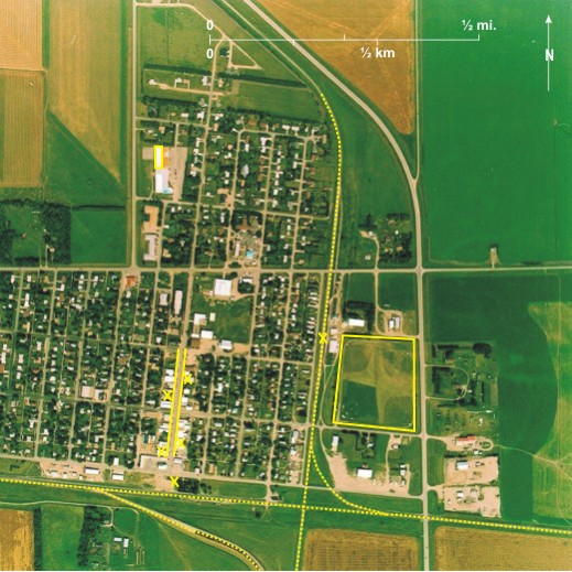
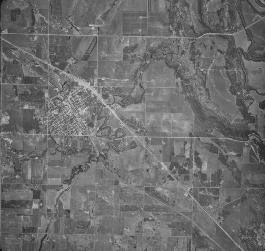
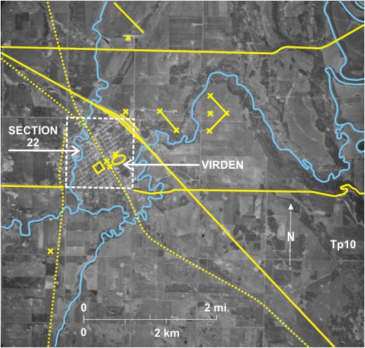
Virden (population 3,010 in 2006) is yet another town where the road pattern is dictated by the railway. The town is located west of the Assiniboine River 1 with
In shape, it is similar to Hartney. The CP line runs northwest/southeast through the centre of town 5, and roads parallel to it and at right angles to it occupy most of section 22, township 10, range 26 WI outlined on the overlay. Elevators are located along the line 6 that splits in the northwest 7. A long abandoned line enters the town from the south 8.
Roads are also prominent. The
Various elements of Virden’s infrastructure can be identified: a centrally located park 15, a racetrack 16 and arena 17, a cemetery 18, and a drive-in cinema 19.[i] To the north are rather primitive runways 20 with associated buildings 21.
Virden is
8.23: La Salle
La Salle, a small hamlet south of
During the 1997 flood of the Red River Plain there was fear that floodwater would enter Winnipeg by avoiding the Red River Floodway and flowing into the La Salle River. The Brunkild dike was built westward across the Red River Plain south of
[[fig. 8.23]]
8.24: Woodlands
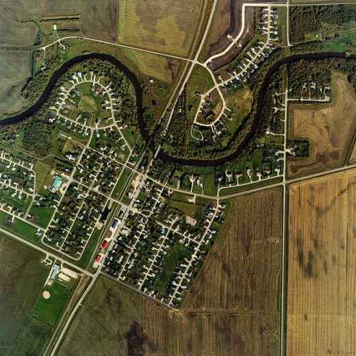
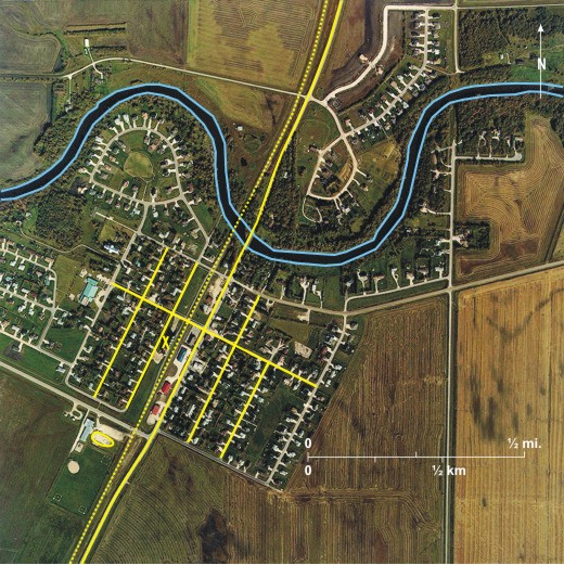
Woodlands in the
[[fig.8.24]]
8.25: Eden
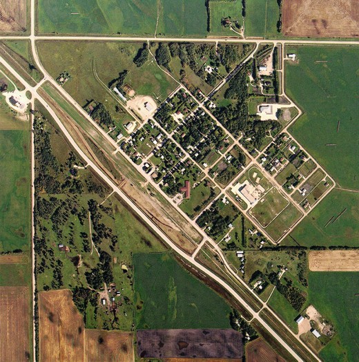
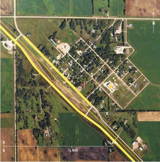
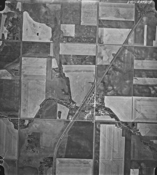
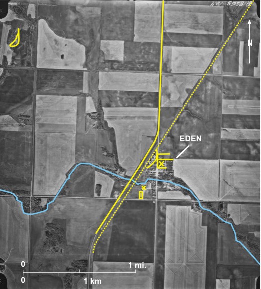
The hamlet of
The large scale of the photo permits identification of some buildings: one larger building on the main street is probably a store 7, in the south is a school 8 with a playing field next to it 9, and near to it is a long narrow building 10, the curling rink.
Most of the land surrounding
[[fig.8.25]]
8.26: Haywood
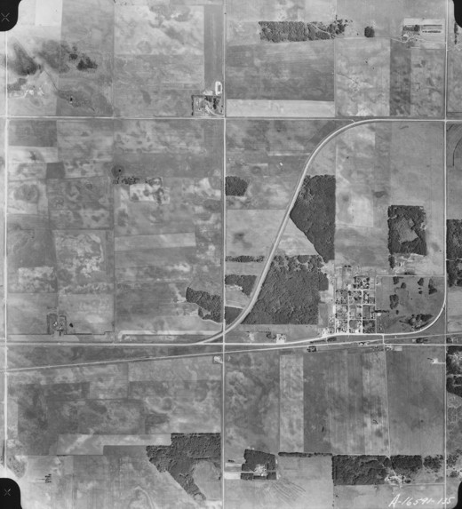
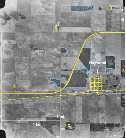
Haywood is located on the
Most of the land has been cleared for agriculture, but still several areas of trees remain 5. Farms are widely distributed 6 with about one per section.
[[fig.8.26]]
8.27: Haywood in 2000
Little has changed in Haywood since the photo in figure 8.26 was obtained. However, a few minor changes can be observed:
1) The elevator (3 on figure 8.26) no longer exists 1.
2) Some houses have been added in the southeast 2.
3) A line of trees in the north has been added 3.
4) Some trees have been removed in the north 4, and a T-shaped building (possibly a poultry barn) has been added 5.
5) Buildings have been constructed west of the most northerly road in the community 6.
[[fig.8.27]]
8.28: St. Leon
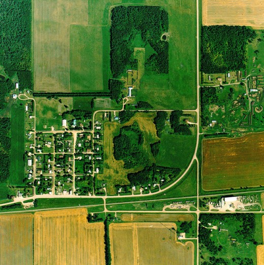
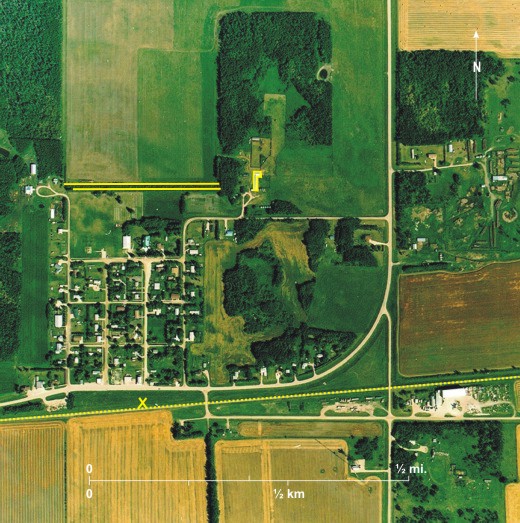
St.
Some patches of trees remain 7 in this agricultural area that is sparsely populated with only one or two farms per section 8. Although the land is flat there is evidence of soil erosion in some locations 9.
[[fig.8.28]]
8.29: St. Leon in 2000
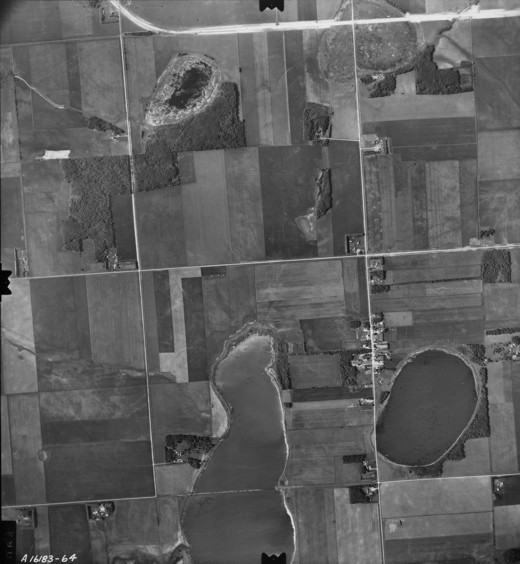
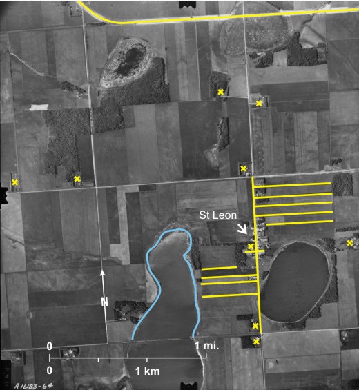
Although St.
1) The widening of the main road along a section line is more evident 1.
2) A north/south road has been constructed east of the main road 2 with a spur 3 along the north edge of the lake.
3) Several new buildings—some houses 4 and some larger buildings 5—have been added between the two north/south roads.
4) Buildings have been added west of the main road—some houses 6 and two large buildings 7; the one in the north may be a school.
5) Fields have been amalgamated both west 7 and east 8 of the main road.
St.
[[fig.8.29]]
8.30: Rapid City
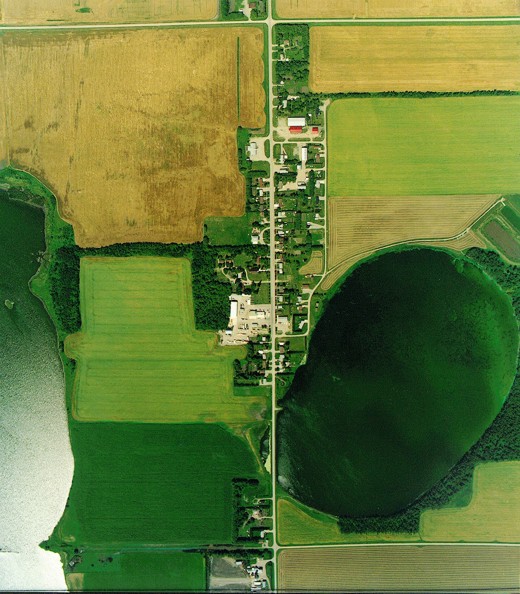
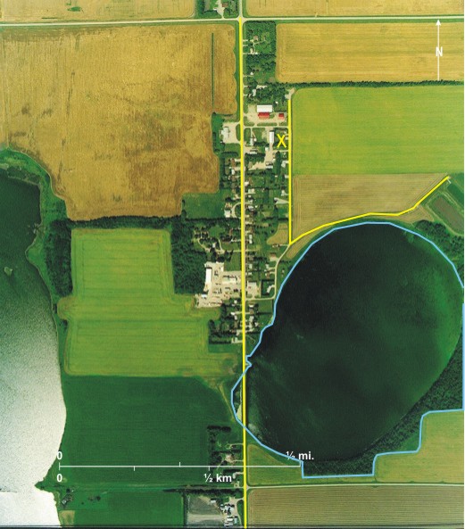
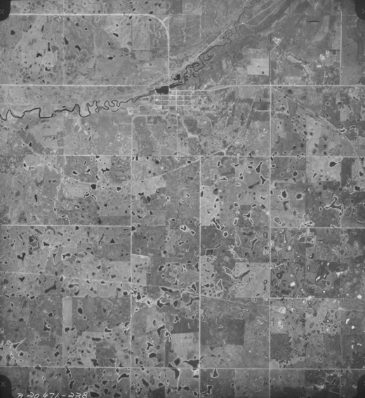
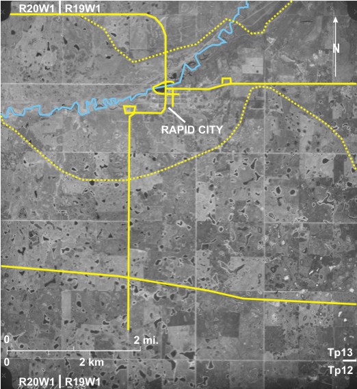
Its location in the Little Saskatchewan Valley would seem to lend itself to something more exciting than a rectangular grid, but not so: the standard grid of north/south and east/west roads is set down on the valley side with no acknowledgement of the topography. Near the centre, two or three roads are wider creating a central business block 2. Two abandoned railway lines (3 and 4) run close to town, the Canadian Pacific in the south 4 following a peculiar route. PTH 24 5 passes through the town, and PR 270 6 enters from the south. The light-toned linear feature in the south 7 is a buried gas pipeline. The Little Saskatchewan River has been dammed to produce a reservoir 8, and the town’s sewage lagoons 9 and cemetery 10 can be identified. It is characteristic of small prairie settlements that both the cemetery and sewage lagoons are located well outside the town limits. [[fig. 8.30]]
8.31: Wawanesa
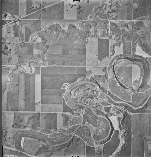
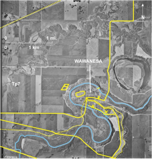
The location of the
Other roads in the village run east/west or north/south, the main street 10 being slightly wider. Wawanesa’s chief claim to fame is that it is the headquarters of the Wawanesa Insurance Company. Established in 1896 to offer farmers protection against fire often caused by steam-driven thrashing machines, it has grown to be a worldwide organization. Officially the headquarters are still in Wawanesa, located in the large building at the south end of Main Street 11. Despite that, the village has never been large. Its population of 516 in 2001 increased to 535 in 2006 probably because it functions as a dormitory community for
Other linear features are, in the north, the Canadian Pacific line 16 and in the extreme south, PTH 2 17 that bypasses Wawanesa. The light-toned linear feature 18 crossing the southwest corner is a buried oil pipeline.
[[fig.8.31]]
8.32: Wawanesa in 2000
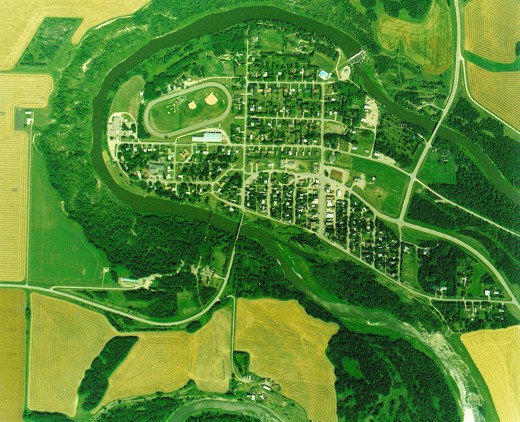
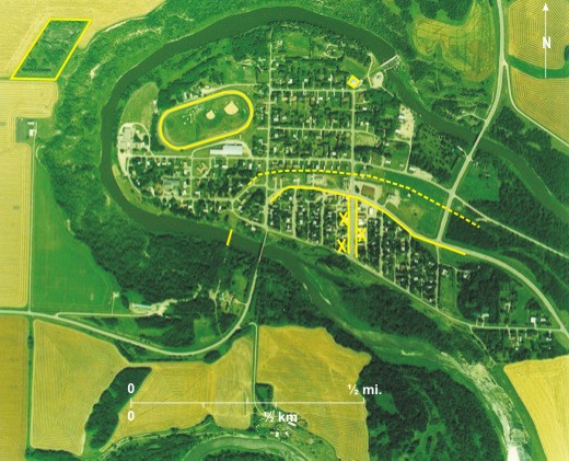
This large-scale colour air photo makes it possible to deduce some aspects of the community better than was possible with the black and white image of figure 8.31 as well as changes that have occurred since 1974.
1) The railway line has almost completely disappeared; only faint indications of its former location can be seen 1. However, the railway bridge still exists 2.
2) The route followed by PR 340 through the village 3 almost parallels the former railway line.
3) The wide main street can be clearly seen 4. Several large buildings can be seen on either side of the street 5, one of which 6 is the headquarters of the Wawanesa Insurance Company.
4) A group of buildings near the apex of the meander loop 7 was visible on figure 8.31, but it is much clearer here. It is probably a school.
5) Further east are two new large buildings 8; these are probably a hockey rink and a curling rink.
6) The racetrack is more obvious on this photo 9; baseball diamonds 10 are located inside the track.
7) A small outdoor pool is located in the north 11.
8) The sewage lagoons 12 in the northwest do not seem to be used now.
9) The contrast between a swathed field with well-defined rows of straw 13 and a field that has been combined, that has indistinct rows 14, is well illustrated on this photo.
[[fig.8.32]]
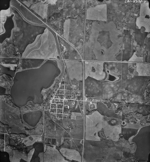
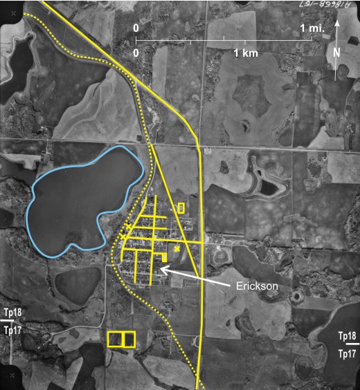
8.33: Erickson
The Town of Many of the usual items of infrastructure can be seen on this large-scale photo. The main east/west road is wider 7 with large commercial and organizational buildings along it. Cars are parked obliquely on this wide street 8. The large round-topped building south of the main street is a rink 9 with an old-style school near it 10. A newer-style school can be seen in the northeast 11. As is usual in small prairie towns, the sewage lagoons 12 are located outside the built-up area, in this case to the south. [[fig. 8.33]]
8.34: Erickson in 2000
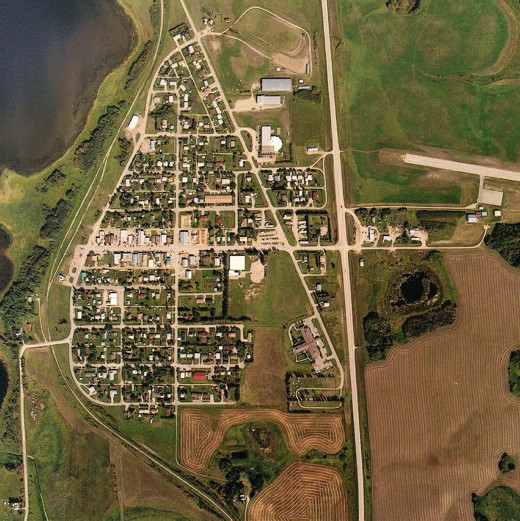
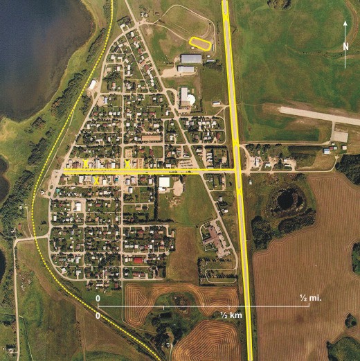
This large-scale colour photo of Erickson reveals several additions and changes to the town since the photo in 8.33 was obtained (1964).
1) The route of the CN railway line to the west of town can still be seen 1 although it is no longer in use. The elevators visible on figure 8.33 have gone.
2) The wide main road 2 is more easily picked out on this photo as are large buildings 3—probably stores—on either side of it.
3) The long narrow building on figure 8.33 (no. 9—identified as a rink) has disappeared and is replaced by a wider building 4 with a car park 5 where the old school used to be (number 10 on figure 8.33).
4) South of town is a new T-shaped building 6, a hospital.
5) The school in the north (number 11 on figure 8.33) has had a new wing added to it 7.
6) Two large buildings have been added in the north 8.
7) Further north is a racetrack 9 which appears disused; it has an outdoor hockey rink beside it 10.
8) A new landing strip 11 is located east of PTH 10 12 on which three vehicles can be seen 13.
[[fig.8.34]]
8.35: Birtle
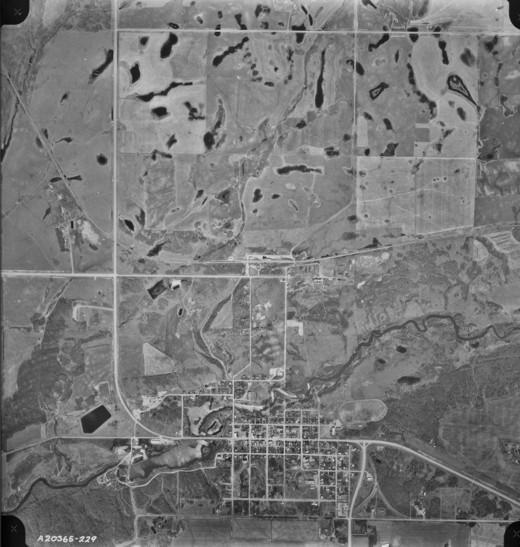
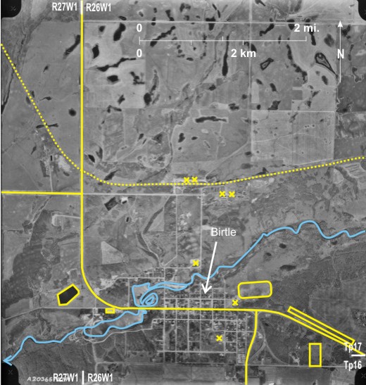
Birtle is an example of a town in which an antecedent business centre was soundly established before the railroad arrived. The railroad, therefore, had to remain on the outskirts while at the same time the original business area managed to remain dominant.[i] On the photograph, the CP line can be seen north of town 1. Two elevators 2 can be seen on it, with just to the south a cluster of buildings 3 which probably house some rail-related industry.
The town is beautifully situated in the
Given the large scale of the photo several items of the town’s infrastructure are identifiable: two schools 8, a hospital 9, a racetrack 10, a cemetery 11, a sewage lagoon 12, and a primitive runway 13. The Birdtail Creek has been dammed 14, creating a lake 15 with recreational features around it. A long building on the north shore 16 is probably a motel.
In recent years Birtle’s population has dropped from a high of 887 in 1981 to 715 in 2001. In an effort to reverse the trend, the town placed advertisements in eastern Canadian newspapers enticing people to relocate here by emphasizing the very low cost of housing, the beautiful setting, and the relaxed atmosphere of rural living. It does not seem to have been successful because the population continued to drop, to 662 in 2006.
[[fig.8.35]]
8.36: Shoal Lake
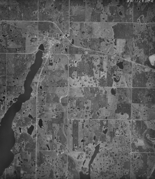
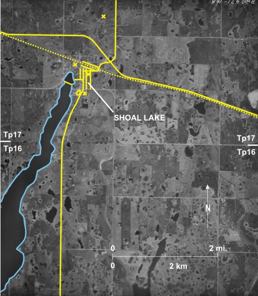
The Town of Shoal Lake (population 680 in 2006) is located at the north end of
At the small scale of the photo, individual items are not easily identified. However, two large buildings 7 may be schools; a large building in the northwest 8 is probably the rink; a racetrack is obvious in the south 9; and a cemetery is located north of town 10.
[[fig.8.36]]
8.37: Ste Rose du Lac
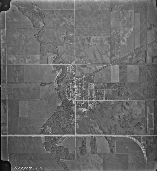
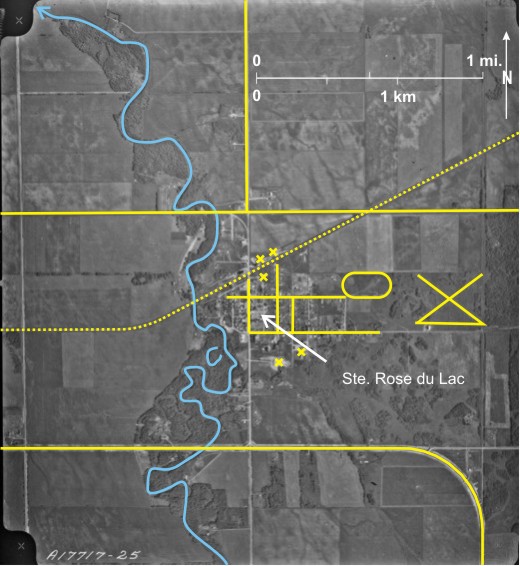
The town of
The large scale of the photo enables the identification of several individual items in the town: in the southeast is a hospital 8; near it is a large building, probably a school 9; a long narrow building in the north is probably a rink 10; and a racetrack 11 and some primitive runways 12 can also be identified. Ste Rose’s main “claim to fame” is a grotto—a replica of the famous grotto at
[[fig.8.37]]
8.38: Russell
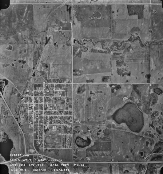
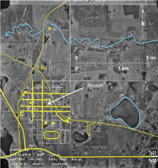
Russell (population 1,428 in 2006) is located in an area of ground moraine topography with many sloughs, some of which have dried up 1. It is situated between the
Russell is another example of a settlement with transport routes skirting it and not influencing its road plan. The CP line 3 runs west of town with two elevators 4 on a siding. North of the town it intersects the CN line 5 which cuts through the northeastern part of the settlement. The CN line has a turning siding 6 and an elevator 7 located just inside the builtup area. PTH 45 and PTH 83 8 skirt the southern edge with 83 leading north 9 and 16 10—The Yellowhead Route—leading west. Only one road 11 that parallels the CN line is influenced by these route ways. All other roads follow the standard grid pattern which harmonizes with the surrounding DLS system.
The main street runs north/south 12 with several large buildings, including the arena 13, located along it. Other items of infrastructure that can be identified are: a racetrack 14 with two schools 15 located north of it; a water tower 16—identified by its shadow; and a trailer park 17. North of town are several long buildings characteristic of a poultry farm 18, and, as usual, the cemetery is located well out of town to the north 19.
Note the information in the bottom left-hand corner of the photo. Air photo A19493-116 is the first photo in line 28 flown from west to east and including photos A19493-116 to 145. The line was flown on May 11, 1969 at an altitude of 9,820 feet above sea level, using a camera with a focal length of 152.47 mm.
Russell is a prosperous rural centre that has gained importance from its location on the increasingly popular
[[fig. 8.38]]
8.39: The Location of Souris
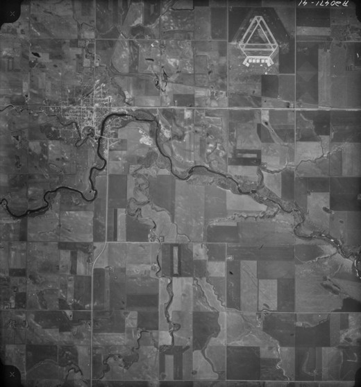
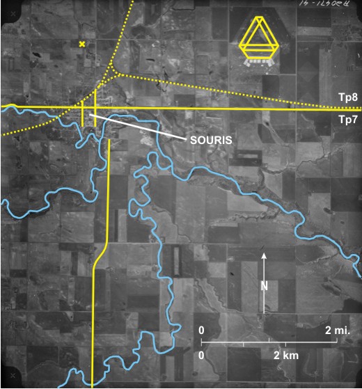
The next two photographs (figures 8.39 and 8.40) included here show the usefulness of small-scale photos for showing the general location of a settlement and of large-scale photos for showing internal detail.
[[fig. 8.39]]
8.40: Souris
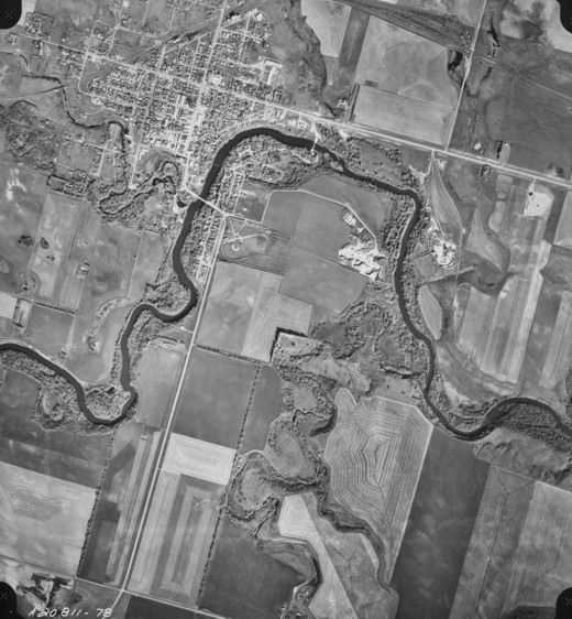
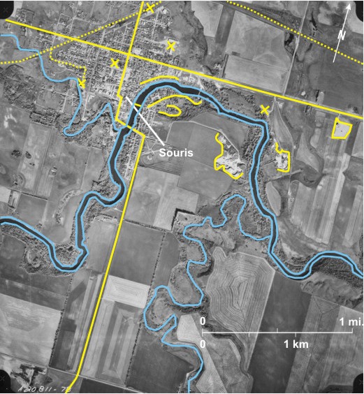
Figure 8.40 is at a much larger scale than figure 8.39 enabling a more detailed interpretation. The Souris River 1 occupies a steep-sided mainly wooded valley 2 in this area. Plum Creek 3 and Elgin Creek 4 can be more clearly seen than in figure 8.39. PTH 22 5 is the main connection between north and south town, but just below the bridge where it crosses the Souris 6 is a faint line 7; this is a foot bridge advertised in brochures as Souris’s swinging bridge. It was taken out by ice during the 1976 flood but has since been rebuilt. Further downstream is another faint line crossing the river 8; this is a weir to raise the river level for water supply. A wooded park is located around the junction of Plum Creek and the Souris River 9.
The main street in
Along the railway line north of town are elevators 15, and rows of railcars can be seen on sidings 16. Another large elevator 17 can be seen on a spur line east of Plum Creek. The town’s dump—strangely termed the “nuisance grounds” in southern
[[fig.8.40]]
8.41: The Location of Minnedosa
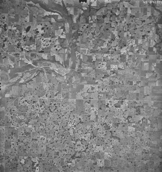
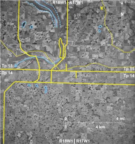
The Town of Minnedosa 1 has a beautiful location in the Little Saskatchewan Valley 2 that can be seen cutting through the northwestern part of the photograph. The steep-sided, flat-floored valley is incised into an area of classic ground moraine topography—pothole country—with numerous sloughs, very dark-toned on the photo 3. The principal transport routes are the CP line 4 which runs through town and then diagonally up the north side of the valley and PTH 10 5 which bypasses Minnedosa to the west. Highway 16 6—the
Land shown on this photo lies within townships 14 and 15, the boundary between the two 12 being the fourth correction line. The correction of about 0.75 mile (1.2 km) 13 can be seen by tracing north/south section lines in the top tier of township 14 north to the township line.
[[fig.8.41]]
8.42: Minnedosa
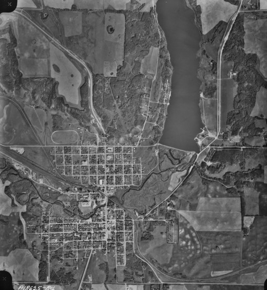
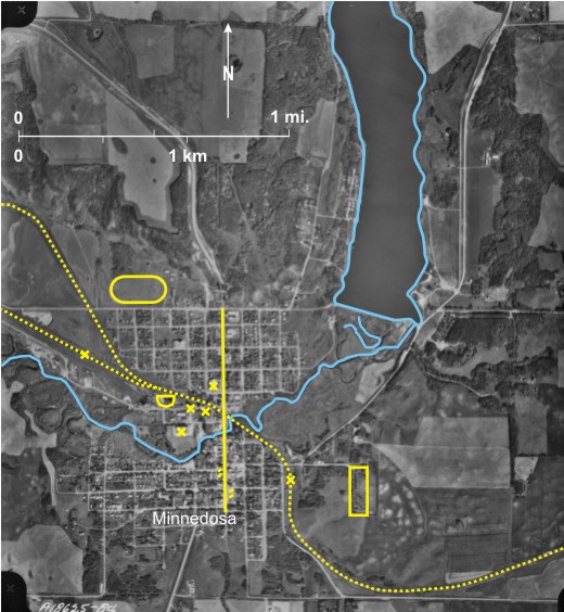
The large scale of this photo shows the detail of Minnedosa’s location in the Little Saskatchewan Valley. Tanner’s Crossing—Minnedosa’s original name—was located here in the general area of the present road 1 and railway crossings 2. It is noticeable that settlement avoids the valley floor just to the northeast where numerous old river channels 3 can be seen in an area now used as a park. Below the crossing two meanders have been artificially cut off 4.
The railway line runs through the town without influencing its street plan, which is the standard grid pattern harmonizing with the DLS system both north and south of the river. West of town are many railway sidings 5 on which a round house 6[i] and elevators 7 can be identified. A train that is about 0.9 miles (1.4 km) long can be seen 8 extending northwest and southeast of the river bridge. The town’s main street runs north/south across the river 9 and under the railway line. Cars—small dark dots—can be seen parked obliquely on this street on both sides of the river 10. Prior to the building of the Minnedosa bypass on PTH 10, the main route from
The Little Saskatchewan River has been dammed to create
Minnedosa is a small rural centre which peaked in population in 1976 (2718) and has declined since—1996 (2443), 2001 (2426). However, it experienced a slight increase to 2, 474 in 2006, possibly benefiting from its proximity to
[[fig.8.42]]
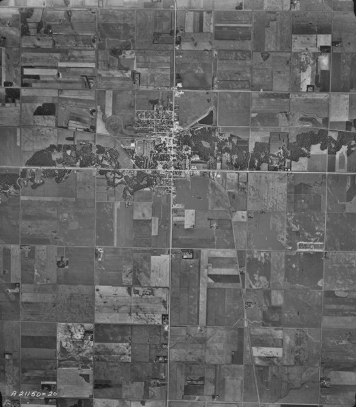
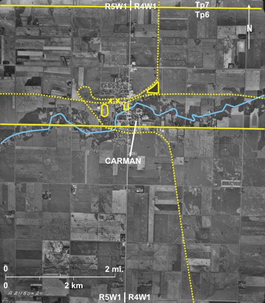
8.43: The Location of Carman
The Town of
Carman is another town with a street plain that has not been influenced by the railway line. Warkentin and Ruggles describe its development as follows : “The central business district is concentrated on
In addition the CN line 8 passes east/west through Carman producing a railway zone, with elevators 9 and railway-associated activities separating the north and south of town. PTH 2 10 passes south of most of Carman with a limited amount of residential development to the south 11. Given the small scale of the photo not a lot of detail can be identified, but three of the standard items of small
Carman is close enough to
8.44: The Location of Neepawa
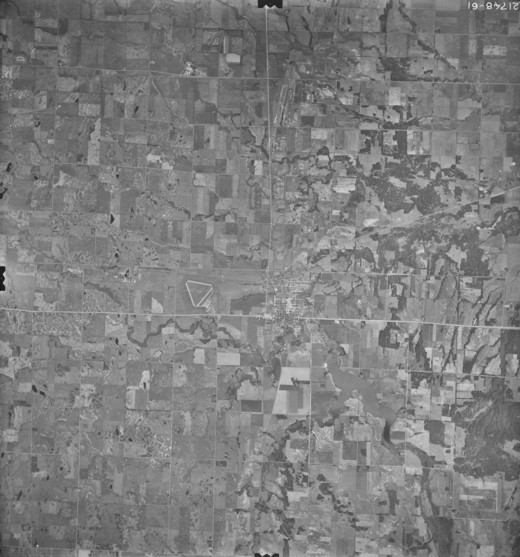
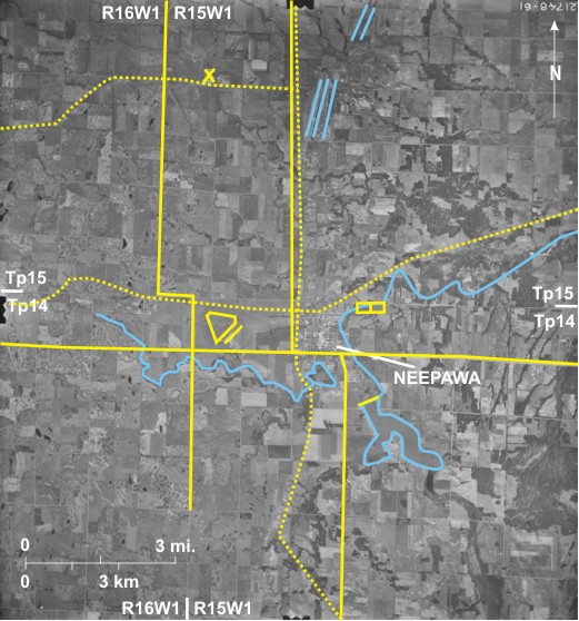
Two photographs (figures 8.44 and 8.45) are used to show the town of
The Town of
The area shown lies in townships 14 and 15 with the fourth correction line between them. The amount of the correction—about 3,500 feet (1066 m)—can be seen by tracing the range line between ranges 15 and 16 WI 10 north to the correction line where it jogs to the west 11.
The main transport routes all avoid downtown Neepawa. The CN line 12, which is best seen in the south, passes to the west of town, and the CP line 13 skirts the north. Neepawa is unusual in that the railway line nearest to it runs north/south and outside the main built-up area. Highway 16—the Yellowhead Route 14—runs through the southern edge of town; and PTH 5 15 enters from the south, follows Highway 16 west for a mile, then branches off to the north well to the west of town 16. Also seen are a western branch line of the CN 17 with a Hutterite Colony on it 18, the town’s airfield 19 with the characteristic triangular shape, and the sewage lagoons 20.
[[fig.8.44]]
8.45: Neepawa
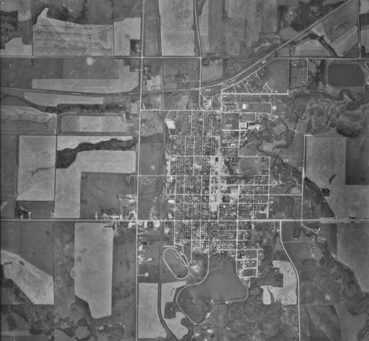
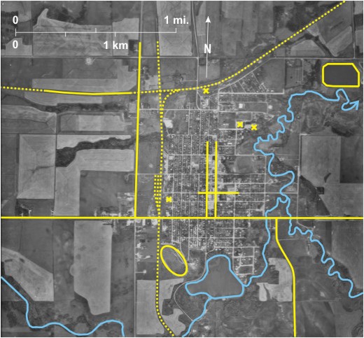
The larger scale of this photo permits identification of more detail about the features noted in 8.44. The Whitemud River 1 east of town is joined by Stoney Creek 2 that flows through
Some individual items can be identified: in the northeast a hospital 18, with a school 19 nearby; in the east a curling rink or arena 20; in the south, a race track with a baseball diamond inside it 21; and in the northeast a sewage lagoon 22 with a golf course near it 23.
The street pattern is the standard grid of straight roads harmonizing with the DLS system. The main “downtown” zone can be seen as a light-toned area 14 encompassing two north/south roads—Mountain Avenue 15 and First Avenue 16—and four east/west streets. Mountain Avenue and one of the east/west streets—
[[fig.8.45]]
8.46: Neepawa in 2000
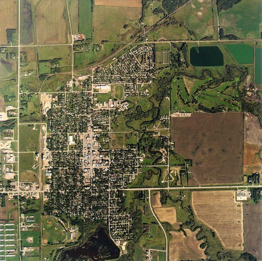
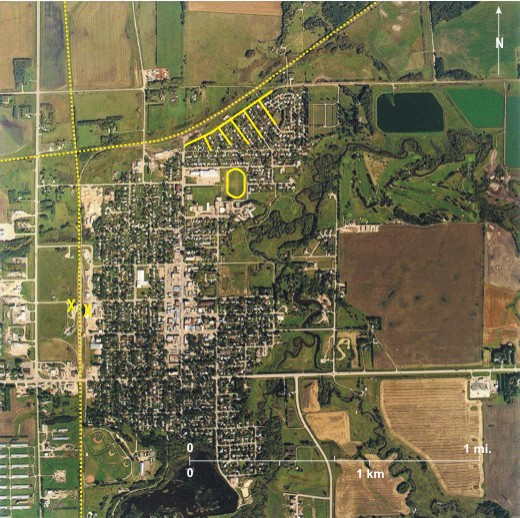
This large-scale colour photo reveals some things better than the black and white image on figure 8.45 as well as several changes since that photo was obtained (1964).
1) Both railway lines—the east/west CP line in the north 1 and the north/south CN line in the west 2 still exist, but the elevator (number 8 in 8.45) has gone. However, two big new elevators are located on the CN line 3.
2) The Central Business District 4 is easily identified because it is a different colour than the surrounding residential areas. The older residential areas are dark green 5 due to the abundance of trees.
3) A large light-coloured building just west of the Central Business District 6 is probably a school. Another school located in the north 7 has a running track 8 beside it.
4) West of the running track is a light-coloured building which probably houses both a hockey rink and curling lanes 9. This building is shown on figure 8.45 but was not identified because its dark tone blended in with its surroundings.
5) A poultry farm with long, narrow sheds 10 is located in the southwest.
6) The sewage lagoons are located in the northeast 11; two of them are green 12, presumably due to algae.
7) Several buildings have been constructed west of PTH 5 13.
8) The residential areas of Neepawa have not expanded a lot, but there has been some infilling of spaces in the south 14, north 15, and northeast 16. In the last area there has also been some expansion to the northeast. It is noticeable that although in virtually all of Neepawa the road pattern harmonizes with the DLS system, in this northeastern residential area one road is parallel to the CN railway line (it is named Railway Avenue 17) with other roads at right angles to it 18.
[[fig.8.46]]
8.47: Beausejour
The Town of
Various individual items of infrastructure can be identified:
a) A school 12 can be seen, with a racetrack to the east 13.
b) A large building 14 just north of the elevators, may be an arena.
c) A Y-shaped building 15 south of the railway line, near the elevators, may be a hospital.
d) Another large building in the south 16 may be a hotel/motel (Beausejour is the gateway to “cottage country” to the east).
e) In the southeast is a large sports complex which includes: four baseball diamonds 17; two large buildings 18 which may house curling rinks (Beausejour has played host to Zone and Provincial Bonspiels); a blue area 19 which may be an outdoor pool; and in the extreme southeast a long oval track 20, which is a power toboggan track (Beausejour hosts the Annual Canadian Power Toboggan Championship Races). A grandstand is located to the west 21.
f) North of the recreational area is a shopping centre 22 with numerous parked cars 23 outside it. Light-toned areas in the west 24 are disused quarries; one of them has filled with water 25. A jetty 26 projecting into it suggests that it has recreational use.
[[fig.8.47]]
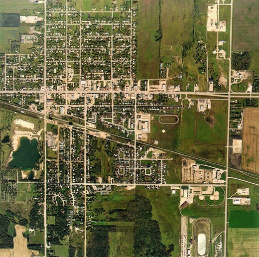
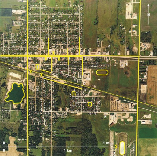
8.48: Landmark
Landmark is a small settlement located on the Red River Plain 25 km southeast of
[[fig.8.48]]
8.49: Waskada
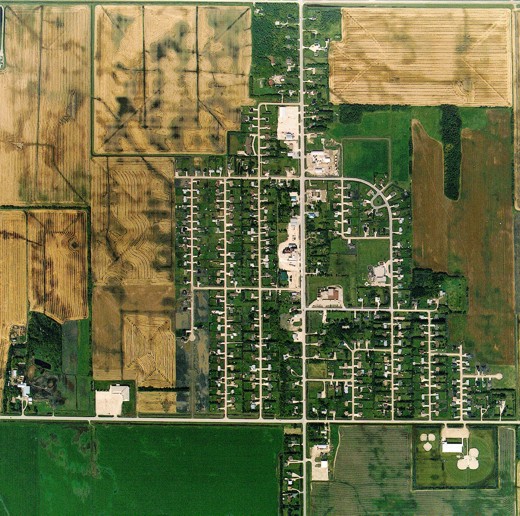
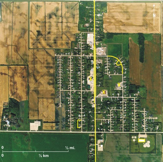
The
The large scale of the photo permits several details to be observed: three elevators 6 on the railway line, a school in the north 7, and a racetrack in the south 8. In this dry area of southwestern Manitoba, water supply is a problem, hence the location of a reservoir 9 south of town and numerous dugouts out of town 10, and sometimes on farms, which are few in this sparsely populated area.
Several of the usual features are located out of town: sewage lagoons to the west 11, with a buried pipe leading toward them 12; a cemetery to the east 13; and a rubbish dump 14.
[[fig.8.49]]
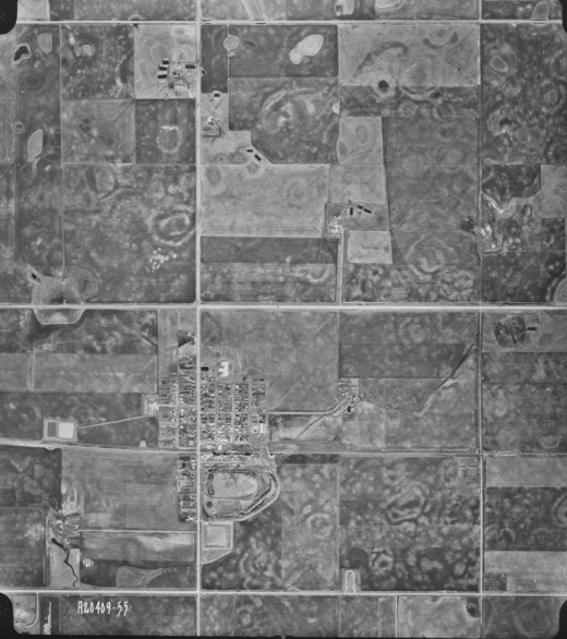
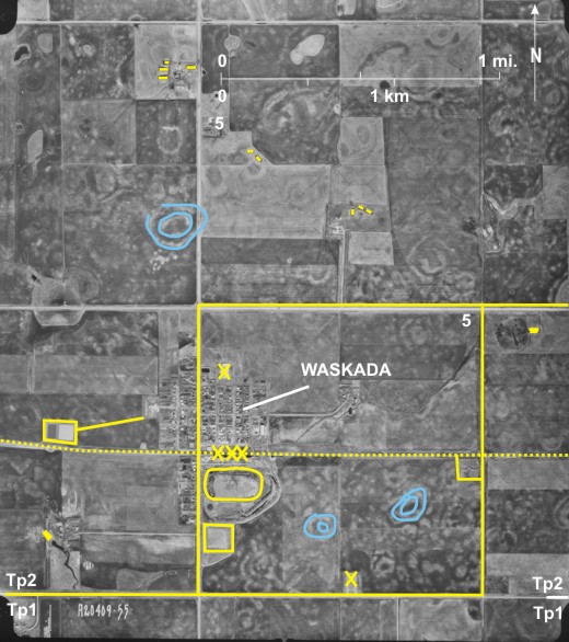
8.50: Miami
PTH 23 6 crosses the middle of the area and is paralleled in the east by the CN line 7 on which three elevators 8 can be seen. Most of
[[fig.8.50]]
8.51: Miami in 2000
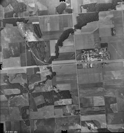
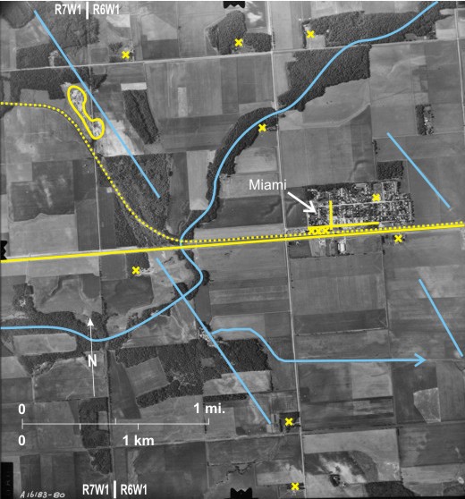
The layout of the settlement is the same as in figure 8.50, but a few additions have occurred, and some items are better seen on this large-scale colour air photo than on the black and white one in figure 8.50.
1) Some infilling has occurred in residential areas in the northwest 1 and southeast 2.
2) Some new houses 3 have been built north of the wide shelterbelt 4 in the north, and a new shelterbelt has been planted around them 5.
3) A new large building can be seen in the east 6, possibly a new school.
4) South of the railway tracks 7 and PTH 23 8 is a new racetrack 9 with a viewing stand to the west 10.
5) Two buildings, a long narrow one 11 and a wider one 12, were in existence when figure 8.50 was obtained. They are more easily identified on this image, and a third building 13 has been added to the east.
6) Only one of the three elevators remains, the most easterly one 14.
[[fig. 8.51]]
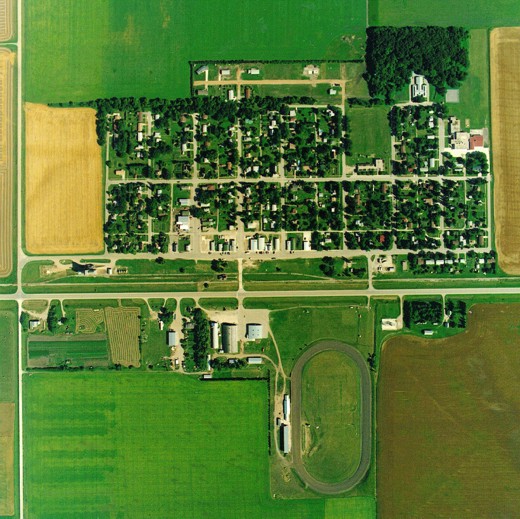
8.52: Deloraine
The Town of
As was the case with
Several of the usual features of small
There is no obvious sign of a surface water supply, but a light-toned line 16 indicates the location of a buried pipeline that brings water to Deloraine from Turtlehead Creek in
[[fig.8.52]]
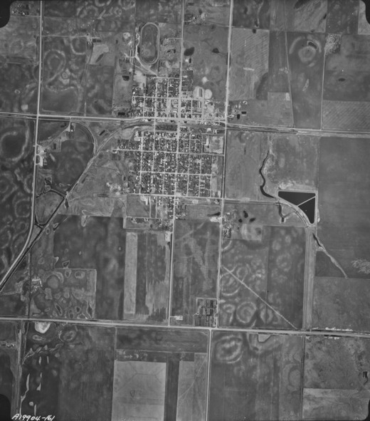
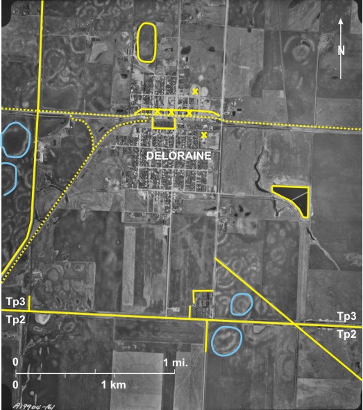
8.53: Altona
The Town of
Well-treed residential areas 15 surround the central commercial area. Trees are not indigenous to this area; most of the trees are probably cottonwoods grown from seed imported from
Altona is a prosperous Mennonite community with a variety of light industries. It has been increasing in population in recent years: 1999, 3,318; 2001, 3,434; 2006, 3,709.
[[fig.8.53]]
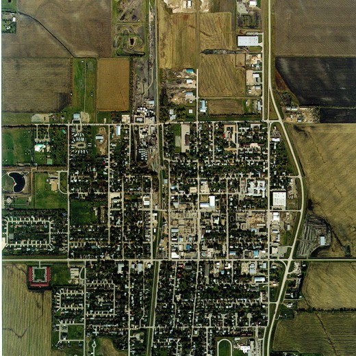
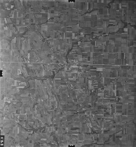
8.54: The Location of Morden
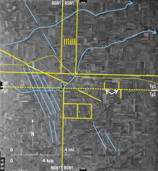
This small-scale image shows the Town of Morden 1 (population 6,571 in 2006) located near the western edge of the Lake Agassiz Plain. West and south of the town are several sets of north-northwest/east-southeast trending strandlines 2. Drainage is generally from west to east by Thornhill Creek 3 in the north and Deadhorse Creek 4 flowing through Morden in the centre. The latter has been dammed to create
This is an intensively farmed area with only limited woodland—dark-toned—along creek courses 6. Sections of the DLS system are clearly visible 7. They are often divided into many fields, sometimes with north/south tree shelterbelts 8. The area lies partly in township 2 and partly in township 3. The first correction line runs along the northern edge of township 2, but here the correction is only about 850 feet (254 m) 9 compared with 5280 feet (1609 m) on figure 8.52.
The main transport routes are the east/west CN line 10 that runs through Morden. In the eastern part of town it runs almost exactly east/west but changes direction both east 11 and west 12 of town. PTH 3 13 runs through the centre of Morden, and a faint light-toned line 14 is the route of a buried pipeline. PR 432 15 is the only important north/south route.
[[fig.8.54]]
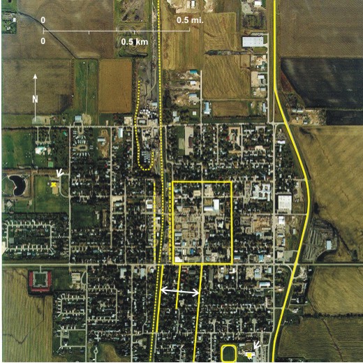
8.55: Morden
On this large-scale image details of the layout of Morden can be seen with Deadhorse Creek 1 flowing through the western part of town. The CN line 2 trends east/west in the east but becomes nearer to west-northwest/east-southeast in the west 3. Two north/south section lines with roads along them run through the east 4 and west 5 of town. That in the west is
PTH 3 10 passes through the centre of town, and in the east it is paralleled by the CN line 11 with two elevators 12 on it. Two sidings—one north 13 and one south 14—diverge from the main line. One east/west road—Stephen Street 15—between the railway line and PTH 3 seems to be the main street; many cars can be seen on it. Along this street and in the area between it and the railway line is the main commercial zone with an abundance of large buildings 16. The town hall 17 is located just outside this zone. The land use north of the commercial zone is mainly residential with tree lined east/west and north/south roads and some bays 18 and crescents. In the northwest is a trailer park 19, a common feature on the edge of
South of the railway line much of the land use is commercial/industrial 25 with some residential development in the southwest 26 and south 27, the latter surprisingly surrounded by commercial/industrial developments. The Agriculture Canada Research Station 28 occupies the southeast corner of the photo with associated buildings just north of the railway line 29. Several parks 30 are located along Deadhorse Creek.
[[fig.8.55]]
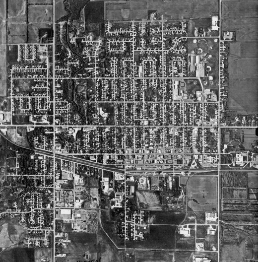
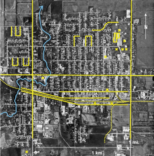
8.56: Holland
Section lines of the DLS are clearly seen, but several do not have roads along them; one in particular is lined with trees 9, an unusual situation for a section line in southern Manitoba.
[[fig.8.56]]
8.57: Holland in 2000
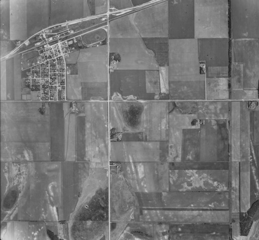
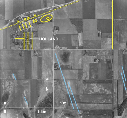
This large-scale colour air photo obtained in 2000 enables more easy identification of features shown on the smaller scale panchromatic photo in figure 8.56, as well as showing changes that have taken place since the photo in figure 8.56 was taken.
1) Only two of the four elevators remain 1.
2) The racetrack 2 that still seems to be in use (races took place at the track in 2006) and contains a baseball diamond 3 inside it is easily identified.
3) There are more buildings south 4 and west 5 of the track.
4) The large building 6 identified as a hockey rink on 8.56 (#8) has a long, narrow building 7 to the south that is probably a curling rink.
5) A new large building in the west 8 could be a school or a seniors’ residence.
6) Residential settlement has filled in one block 9 and has spread further west 10 and east 11 than on figure 8.56.
[[fig.8.57]]
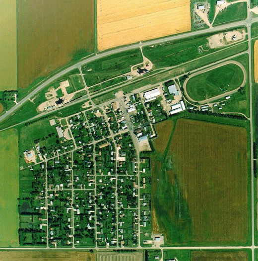
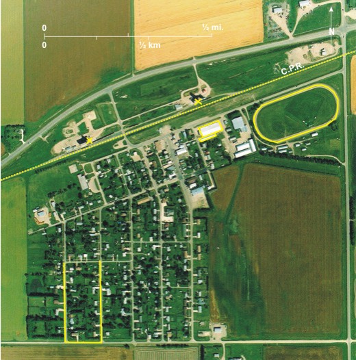
8.58: Tyndall
The small community of Tyndall is located northeast of
[[fig.8.58]]
1) A long, narrow building 9 located just west of a north/south road 10 that runs along a section line. Given the shape of the building it probably houses a curling rink.
2) Sewage lagoons 11, as usual, are located well outside the built-up area—in this case to the west.
3) Even though the photo was taken in the summer there are wet patches in the fields 12.
Tyndall gives its name to Tyndall Stone although the stone is quarried at Garson, two miles (3.2 km) to the east. It was shipped from Tyndall.
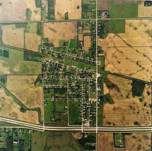
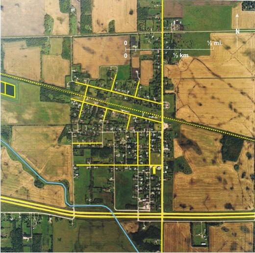
8.59: Elkhorn
The
Several of the usual items of infrastructure can be seen: a school 7, a rink 8, and a racetrack 9.
[[fig. 8.59]]
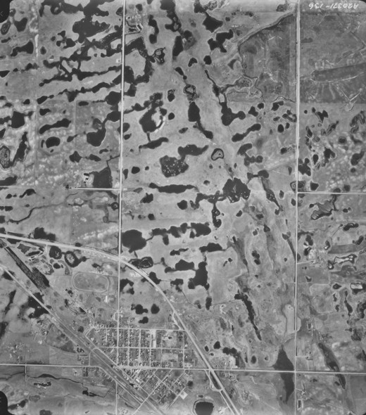
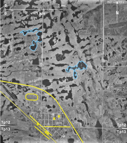
8.60: Melita
The town of
[[fig.8.60]]
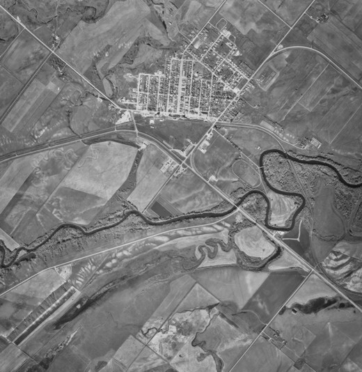
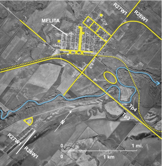
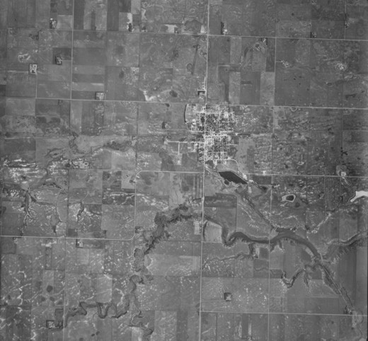
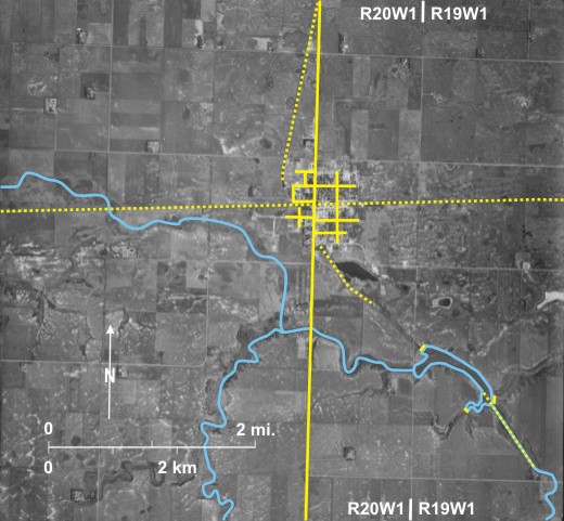
8.61: The Location of Boissevain
The Town of
[[fig.8.61]]
8.62: Boissevain
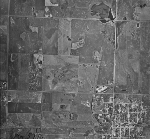
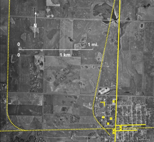
All the items mentioned in the description of figure 8.61 can be seen on this image along with other details. For example, a spur 1 runs north from the CP line 2 1 mile (1.6 km) west of town. Where the CP line runs through the town, there are two roads parallel to it—one on either side—with that on the south being wider 3. Between the two roads is a “railway zone” with elevators 4 and other railway-related buildings. In an effort to encourage travelers to stop in Boissevain murals have been painted on elevators and other buildings in the town. Other elevators 5 can be seen just west of PTH 10 6 where the old railway line used to exist. Several of the usual items of infrastructure can be seen: a school 7 with a racing track and baseball diamond 8, and several other large buildings west of highway 10 9 which probably include an auditorium/arena 10 and a hospital.
[[fig.8.62]]
8.63: Roblin
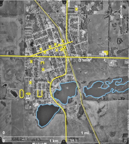
The Town of
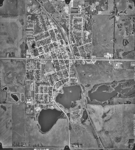
The CN line 6 passes between two of the lakes and continues in a north-northwest direction through the town 7 before curving to a northwest direction 8. Elevators 9 can be seen on the part of the line that runs in a north-northwest direction. The town’s main road 10 is at right angles to the railway line. Cars can be seen parked obliquely on this road 11 that is wider than other roads. Also many large buildings are located along it 12 and on side roads at right angles to it 13. Roblin is at the intersection of north/south PTH 83 14 and east/west PTH 5 15 which almost bisects the town.
Various individual items can be identified: a recreational area 16 which includes a running track 17 and a curling rink 18; three schools 19; a hospital 20; and a seniors complex 21 and a motel 22. A trailer court—a common feature on the fringes of
[[fig.8.63]]
8.64: Swan River
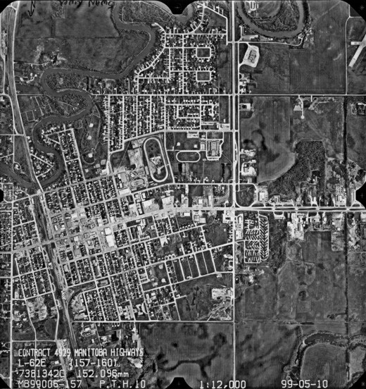
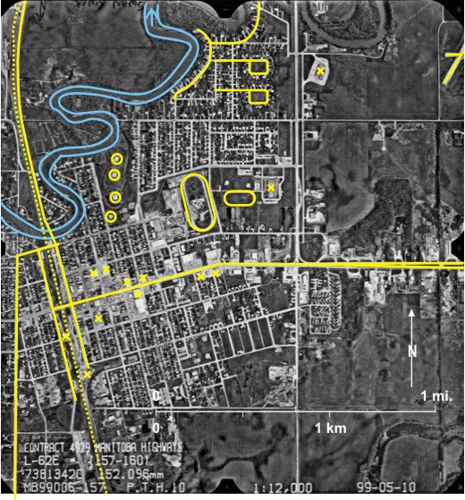
The town of
The older part of town is oriented with respect to the CN line 2 that passes through it in a north-northwest/south-southeast direction. Roads are parallel to and at right angles to this line. Two roads, one on either side of the line 3, run parallel to it defining a railway zone with elevators 4 located along it. PTH 10 5 enters town from the east where it has the form of a divided highway 6. Further west it turns slightly south to harmonize with the railway-determined road pattern. Here it is wider than the other roads 7 and is clearly the main street. A commercial zone, with many large buildings 8, has developed along it and a number of side streets 9. PTH 83 enters from the south 10.
The newer outskirts of town have a road pattern that harmonizes with the DLS system. This is particularly the case in the north, but near the northern edge the grid breaks down, and bays 11 and curved roads along the river 12 using the topography can be seen. Trailer courts 13 are located in the east.
Individual items that can be identified are: racetracks 14, one of which is associated with a school 15, a recreational area with four baseball diamonds 16, a hospital 17, and an airfield 18.
[[fig.8.64]]
8.65: The Location of Shilo
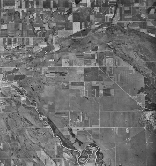
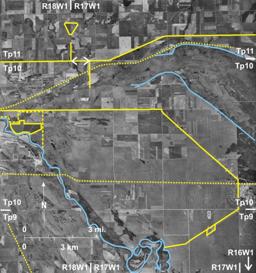
Shilo is different from settlements shown previously in that it is relatively new, and its principal function is as a military base for troops training at CFB Shilo that covers a large part of the Assiniboine Delta. This high-level image shows the general setting of the community and its relationship to others in the area. The Assiniboine River 1, incised into the Assiniboine Delta, cuts across the southwest corner of the image. In the south the east bank 2 has retreated eastward as a result of spring sapping, and one abandoned meander 3 can be seen. The surface of Assiniboine Delta is flat and bounded in the north by Douglas Marsh 4, a former course of a distributary of the
Route ways that can be seen are Highway 1 6—the
The boundary between townships 10 and 11—the third correction line—runs through this area with a correction of about 0.75 mile (1.2 km) 18. Shilo is located in part in range 16 WI—the military part 19 that is in the
[[fig.8.65]]
8.66: Shilo
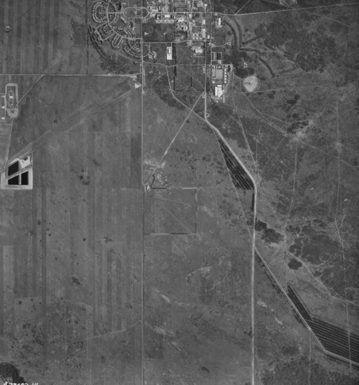
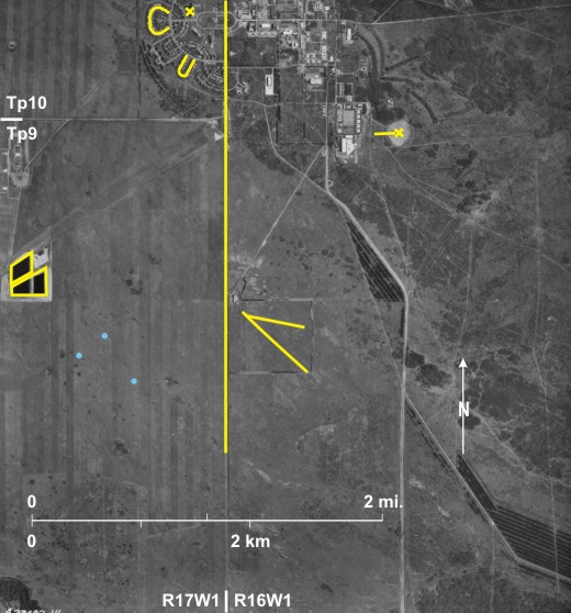
More detail can be seen on this image than on figure 8.65. The range line between R 16 WI and R 17 WI 1 separates the military area to the east 2 from the residential area to the west 3. The residential area is unusual in having a series of bays and crescents 4 in contrast to the usual grid. Southwest of the residential area are the sewage lagoons 5, and just to the north are a group of buildings 6 which probably have some military function. Within the residential area one large building is a school 7, and in the military area a group of buildings is a hospital 8. In the southeast is a tall structure 9 throwing a shadow due west 10, indicating that the photo was taken in the early morning. This is a paratroop training tower.
Around the settlement the plain to the south and west is mainly grass-covered with dark-toned, roughly circular patches of creeping juniper (Juniperus horizontalis) 11. Land to the east is more hilly and partly tree-covered 12, mainly by aspen (Populus tremuloides). Two areas of exotic planted pine can be seen south of town 13, and a small golf course 14 is located to the east. Primitive runways can be seen in the south 15.
[[fig.8.66]]
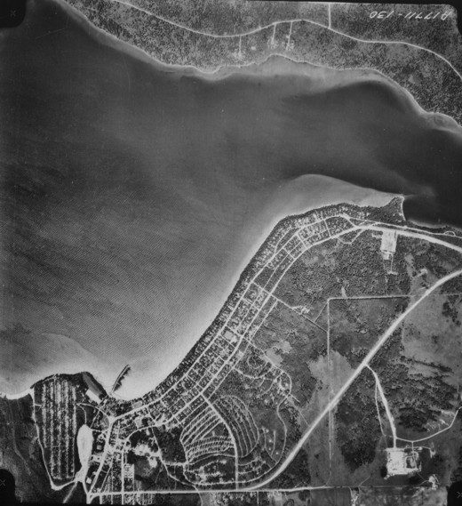
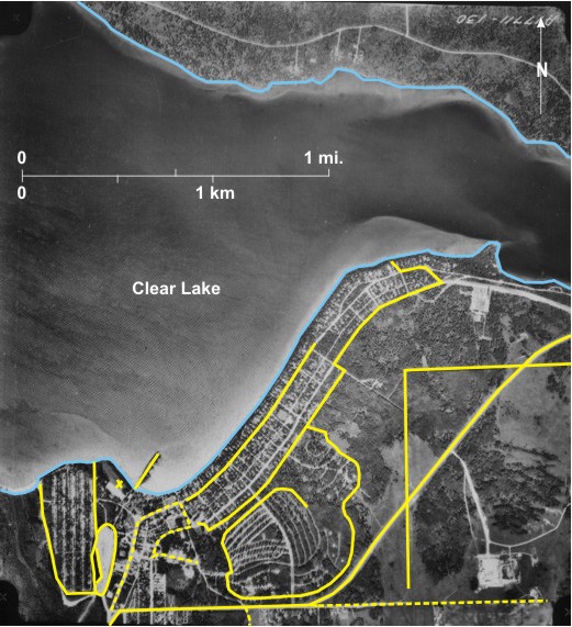
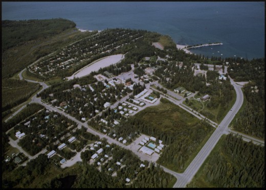
8.67: Wasagaming
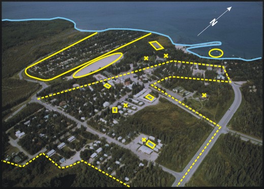
The combination of being a semi-urban tourist resort located in a national park and the strongly seasonal nature of its activities, make Wasagaming a unique settlement in
The town can be divided into five functional areas.
1. In the east is a commercial area 3 oriented towards tourists; it includes hotels, motels, cabins, restaurants, gift shops, and clothing stores.
2. Outside this area to west 4 and east 5 are the National Parks services: the park administration building; visitor and interpretation services; the fire hall; the community centre; recreational facilities such as tennis courts 6, playground, marina; and public beach 7. Also included is a large parking area 8 to accommodate large numbers of summer visitors.
3. To the east is the Clear Lake Seasonal Campground 9 opened in 1963, which consists of a very dense grouping of seasonally opened cabins and trailers. These are held by campers on a yearly basis.
4. To the west is the Wasagaming Campground 10 which offers over 500 serviced and non-serviced lots for campers. People can camp here for days or perhaps weeks, but they are not allowed to rent for the whole summer season.
5. North of the campground is the prestigious and expensive area of summer cottages occupying land leased from the park 11.[ii] Some of these are very elaborate and are handed down from generation to generation but still occupancy is possible for only a few months in summer. Since the photo was taken another sub-division has been added on the north
Other items that can be identified are the rubbish dump 13 and the maintenance compound 14 where equipment is kept. PTH 10 15 runs southeast of Wasagaming following a more direct route than the old road 16 which used to run along section lines.
Obtaining a cabin in Clear Lake Seasonal Campground is difficult, and obtaining a cottage in the upscale residential area is both difficult and expensive. Partly in consequence there has been enormous expansion of cottage buildings outside the park but in close proximity to it to make use of its facilities. Wasagaming is unique in Manitoba in that its permanent residential population is almost zero, but during busy summer weekends the influx of people make it the third largest settlement in Manitoba.
[[fig.8.67]]
8.68: Wasagaming (Large-Scale)
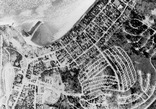
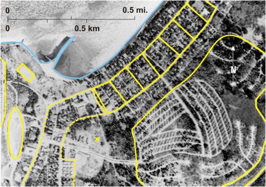
The larger scale of this photo permits the identification of some detail not obvious on figure 8.67. The photo was taken during the spring when ice on
[[fig. 8.68]]
8.69: Oblique Photo of Central Wasagaming
The photo was taken looking northwest with
[[fig. 8.69]]
8.70: Pinawa
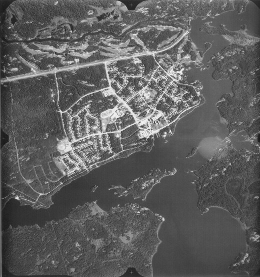
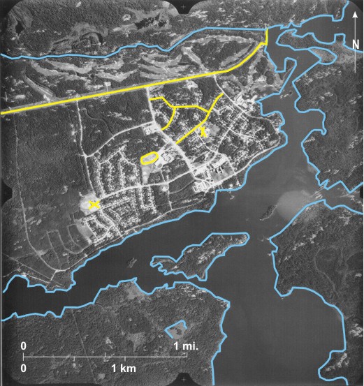
Pinawa is different from most other settlements in southern Manitoba in several respects: 1) it is located on the Canadian Shield, so agriculture has played no direct part in its history; 2) land in the area surrounding it is thickly wooded and is not easily divided into sections; 3) it is not located on or near a railway line; and 4) it is organized as a local government district rather than as a village or town.
Shown on the photo is part of the
The settlement of Pinawa is served by PR 211 3 from the west and was established as an Atomic Energy of Canada research centre. It is therefore much newer than most settlements in southern
Several clusters of large buildings can be seen 5 which are probably research labs. The large building 6 near the running track 7 is probably a school. Recreation for employees includes golf—a course is located in the north 8—and boating—a marina 9 can be seen in the centre.
Except where trees have been removed for buildings, the land is covered by dark-toned coniferous forest 10 with occasional marshy areas 11.
[[fig. 8.70]]
8.70: Delete this 8.71