Chapter 19: Legal Issues and Law Enforcement
Vertical air photos record situations that exist at a specific time and are particularly useful in recording changes if a sequence of photos of the same area exists. Property boundaries are difficult to define if they fall along a naturally changing feature such as a river channel. Three examples illustrate the legal problems that can arise.
The Western Boundary of Birdtail Sioux First Nation Near Beulah
Rivers have traditionally been used as boundaries between various administrative units: municipalities, counties, provinces, states, and even countries. However, they are unsatisfactory administrative boundaries because they change position over time resulting in ownership disputes.
In
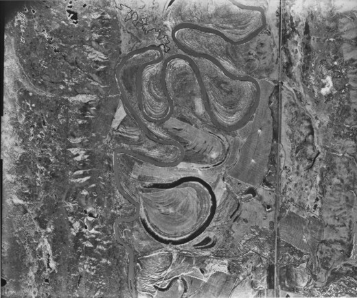
19.1: Meanders on the Assiniboine River Near the Junction with Birdtail Creek, 1945 Photo
On this stretch of the southward-flowing
[[fig. 19.1]]
19.2: Meanders on the Assiniboine River Near the Junction with Birdtail Creek, 1956 Photo
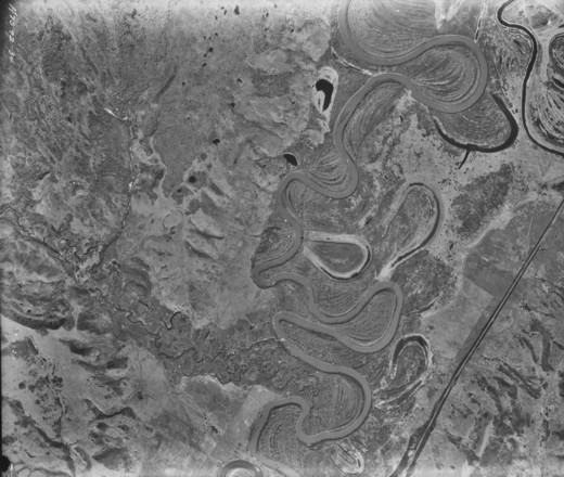
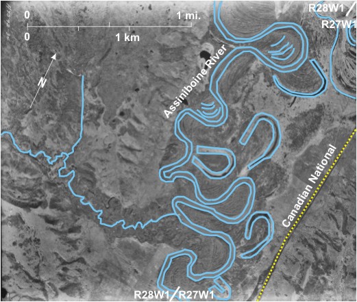
Abandonment is still imminent at 7 but at 8 breakthrough has recently occurred; water now flows in a direct route across the meander neck as well as round the meander. This photo was taken from a greater height than figure 19.1 and consequently covers a larger area at a smaller scale. A cut off appears imminent 9, and existing cut offs can be seen to the north (10,11,and 12) and to the south 13. On this photo there is a very clear distinction between the dark tones of the cut offs and the light tone of the sediment-laden main channel.
[[fig. 19.2]]
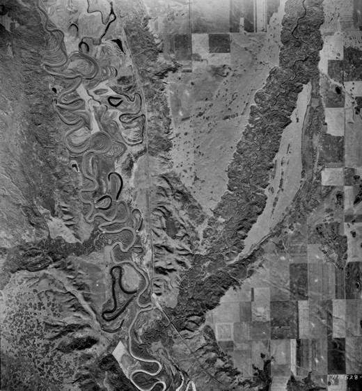
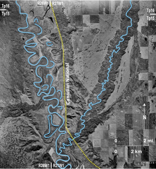
19.3: Meanders on the Assiniboine River, Near the Junction with Birdtail Creek, 1994 Photo
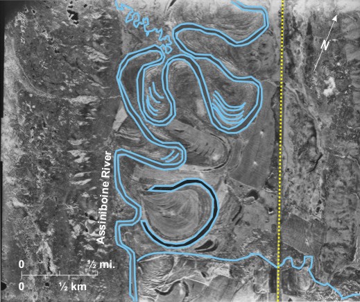
This photo taken 38 years after that in figure 19.2 is at a larger scale and covers only the southern part of that photo. The “imminent cut off” at 8 is now completely abandoned, and, as its dark tone indicates, water no longer flows through it. Also, the “imminent cut off” at 9 has been abandoned, but historical records reveal that it was artificially cut off to prevent erosion of the Canadian National Railway line 14. Two other cut offs can be seen in the south (15 and 16) as well as an abandoned river segment 17. It seems likely that the main channel of the
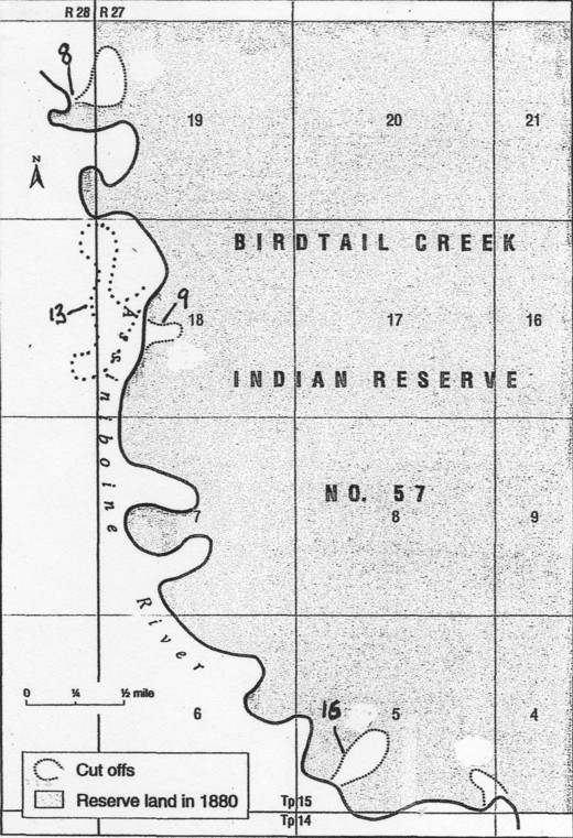
Changes in river position in this area are of more than academic interest because the western boundary of the Birdtail Sioux First Nation is defined by the course of the
South fifteen chains and seventy five links, more or less, along the western boundary of said section 19 to its intersection with the left bank of the Assiniboine River; hence south easterly along the said bank of the said river to its intersection with the southern boundary of section four in said township.[i]
This intersection is located about a mile east of the eastern edge of the photo in figure 19.3.
A dashed line on the overlay marks the boundary. If the above wording is retained today and the east bank of the main course of the river defines the boundary, the size and shape of the First Nation will have changed. In the area of one cut off 8 the First Nation has gained some land but has lost more than it gained. However, the effect of the cut offs (9 and 16) will have been to add land to the First Nation (figure 19.4). Further complications will arise if the
[[fig.19.3]]
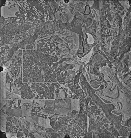
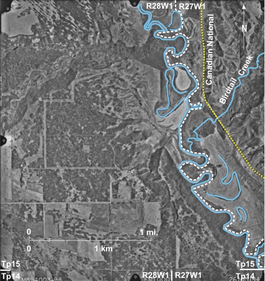
19.4: Map of the Western Boundary of Birdtail Sioux First Nation
[[fig.19.4]]
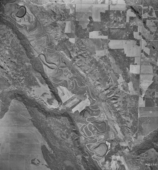
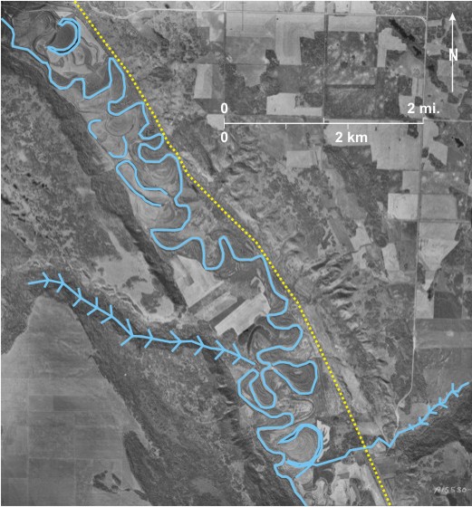
19.5: The Boundary of the Hudson Bay Company Reserve at Fort Ellice, 1945 Photograph
The sequential photos shown in figures 19.5, 19.6, and 19.7 were taken in 1945, 1956, and 1994 respectively.
On figure 19.5 there is one prominent dark-toned oxbow lake 1 and three imminent cut offs (2, 3, and 4). Eleven years later (figure 19.6) the imminent cut off 2 has occurred leaving behind a relatively dark toned oxbow lake 5; the imminent cut off 3 is very close, whereas the third one 4 has some way to go. On figure 19.7, 38 years later the imminent cut off 3 has occurred, leaving behind an oxbow 6, but the meander neck at 4 is still extant.
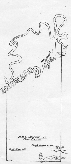
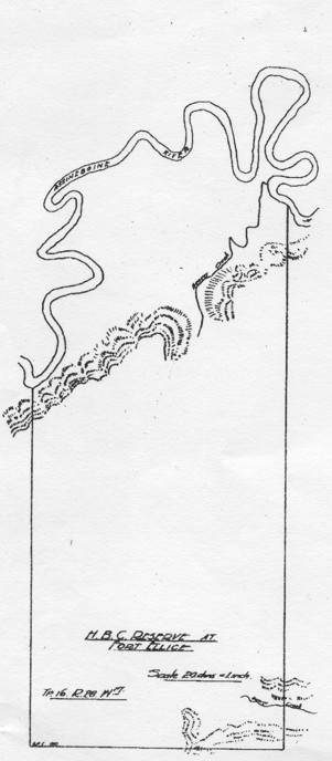
The significance of these changes for land ownership is profound in that the original boundary of the Hudson Bay Company Reserve is the west bank of the main river channel (figure 19.8). Neither of the two imminent cut offs (2 and 3) had occurred by 1920 (figure 19.9). If the western bank of the main channel of the river is maintained as the boundary of the reserve, a large area of land surrounded by the two oxbows (5 and 6) has been lost.[i] It would be interesting to trace land ownership in the area over the last 100 years.
[[fig.19.5]]
19.6: The Boundary of the Hudson Bay Company Reserve at Fort Ellice, 1956 Photograph
The sequential photos shown in figures 19.5, 19.6, and 19.7 were taken in 1945, 1956, and 1994 respectively.
On figure 19.5 there is one prominent dark-toned oxbow lake 1 and three imminent cut offs (2, 3, and 4). Eleven years later (figure 19.6) the imminent cut off 2 has occurred leaving behind a relatively dark toned oxbow lake 5; the imminent cut off 3 is very close, whereas the third one 4 has some way to go. On figure 19.7, 38 years later the imminent cut off 3 has occurred, leaving behind an oxbow 6, but the meander neck at 4 is still extant.
The significance of these changes for land ownership is profound in that the original boundary of the Hudson Bay Company Reserve is the west bank of the main river channel (figure 19.8). Neither of the two imminent cut offs (2 and 3) had occurred by 1920 (figure 19.9). If the western bank of the main channel of the river is maintained as the boundary of the reserve, a large area of land surrounded by the two oxbows (5 and 6) has been lost.[i] It would be interesting to trace land ownership in the area over the last 100 years.
[[fig.19.6]]
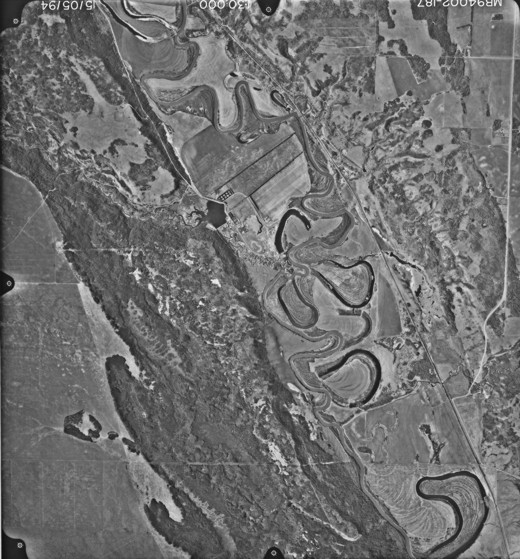
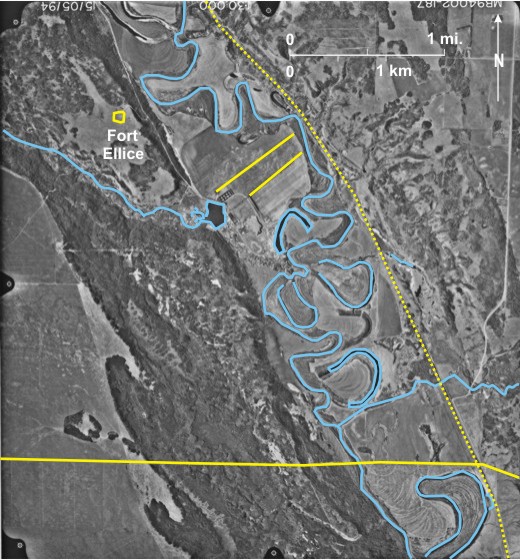
19.7: The Boundary of the Hudson Bay Company Reserve at Fort Ellice, 1994 Photograph
The sequential photos shown in figures 19.5, 19.6, and 19.7 were taken in 1945, 1956, and 1994 respectively.
On figure 19.5 there is one prominent dark-toned oxbow lake 1 and three imminent cut offs (2, 3, and 4). Eleven years later (figure 19.6) the imminent cut off 2 has occurred leaving behind a relatively dark toned oxbow lake 5; the imminent cut off 3 is very close, whereas the third one 4 has some way to go. On figure 19.7, 38 years later the imminent cut off 3 has occurred, leaving behind an oxbow 6, but the meander neck at 4 is still extant.
The significance of these changes for land ownership is profound in that the original boundary of the Hudson Bay Company Reserve is the west bank of the main river channel (figure 19.8). Neither of the two imminent cut offs (2 and 3) had occurred by 1920 (figure 19.9). If the western bank of the main channel of the river is maintained as the boundary of the reserve, a large area of land surrounded by the two oxbows (5 and 6) has been lost.[i] It would be interesting to trace land ownership in the area over the last 100 years.
[[fig.19.7]]
19.8: Map of Hudson Bay Company Reserve, 1873
[[fig. 19.8]]
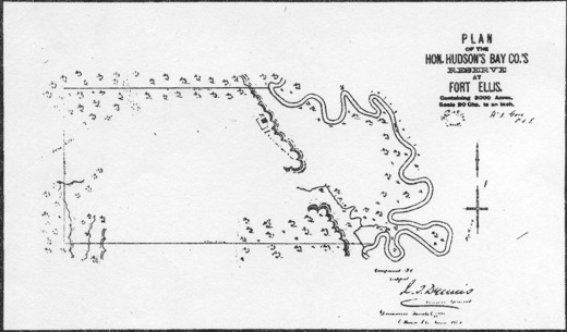
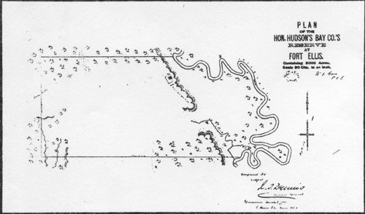
19.9: Map of Hudson Bay Company Reserve, 1920
[[fig. 19.9]]
19.10: Land Dispute on the Banks of the Assiniboine River, Southwest of Portage la Prairie, 1989 Photograph
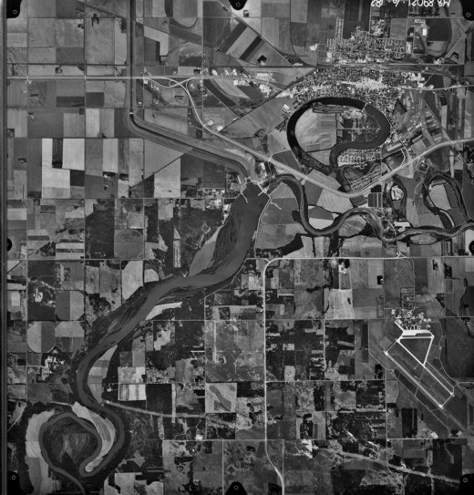
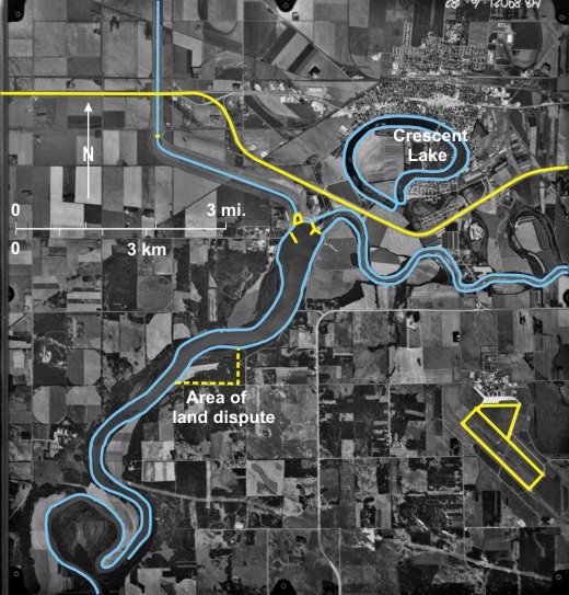
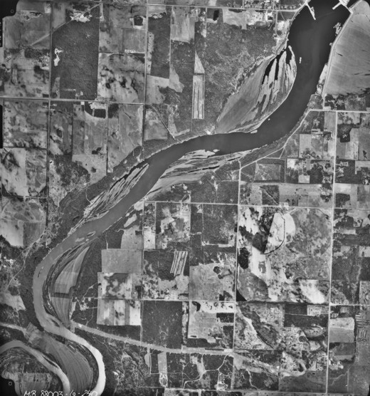
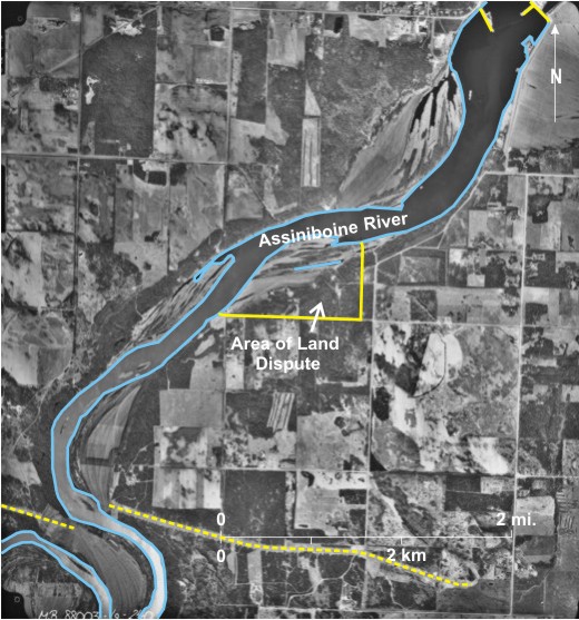
Figure 19.10, a 1989 photo, shows the city of Portage la Prairie 1, the Trans-Canada Highway bypassing the city to the south 2, and the Southport airfield 3. The Assiniboine River 4 flows from southwest to east across the area. As part of a flood control scheme to protect both Portage la Prairie and Winnipeg, a dam 5 has been built across the river to deflect water into the Portage Floodway 6 at times of high flow. It is noticeable that the river channel is wider behind the dam 7 than it is downstream from it 8. A dispute arose over compensation for land that was flooded as a result of the building of the dam. The area concerned is bounded by a dashed line. [[fig.19.10]]
19.11: Land Dispute on the Banks of the Assiniboine River, Southwest of Portage la Prairie, Map of Land Divisions, 1875
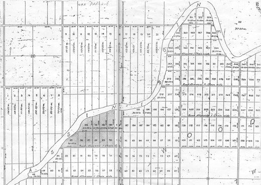
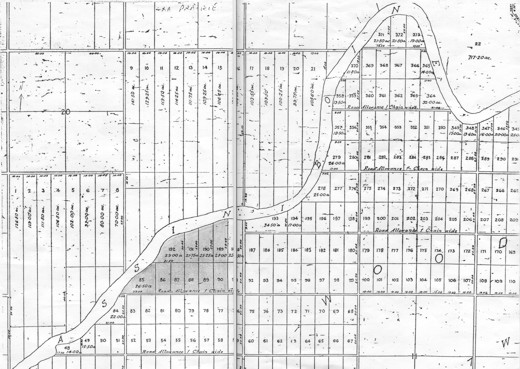
Figure 19.11 is a map showing land divisions established in 1875 along the Assiniboine River in the area of the land dispute. A farmer bought land in this area in 1961 based on a plan filed in 1875. In the years following the survey, land was accreted by deposition on the inside of the river bend.
The area of the land dispute is shaded.
[[fig.19.11]]
19.12: Land Dispute on the Banks of the Assiniboine River, Southwest of Portage la Prairie, 1959 Photograph
Figure 19.12 is an air photo that shows the situation in 1959, before the Portage Dam was built. Meander scrolls 9 are visible south of the river. Over the years the farmer brought land accreted in this area into cultivation. However, in connection with the building of the Portage Floodway, the Province of Manitoba expropriated part of his land because it was expected that it would be flooded by backwater behind the dam.
[[fig.19.12]]
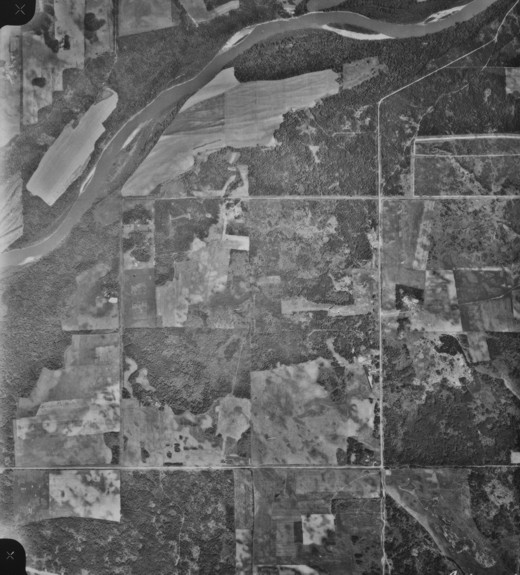
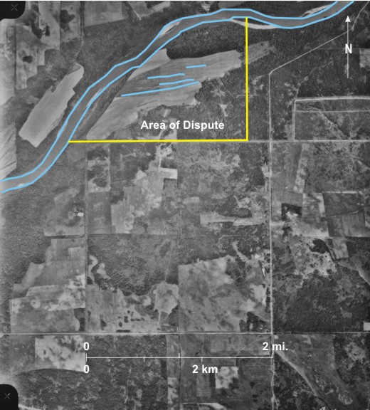
19.13: Land Dispute on the Banks of the Assiniboine River, Southwest of Portage la Prairie, 1988 Photograph
Figure 19.13 is a 1988 air photo of the area and it can be seen that flooding did indeed occur. Dark-toned areas 10 south of the main river channel are inundated. The land expropriated by the Province included 59 acres of the accreted land, but the farmer was awarded compensation for the land shown on the original title (the shaded area on figure 19.11), that is, excluding the accreted land.[i]
[[fig.19.13]]
19.14: Headingley Gaol
Headingley Correctional Institute 1, opened in 1930, is the oldest of seven provincial correctional institutes in
[[fig. 19.14]]
19.15: Stony Mountain Penitentiary
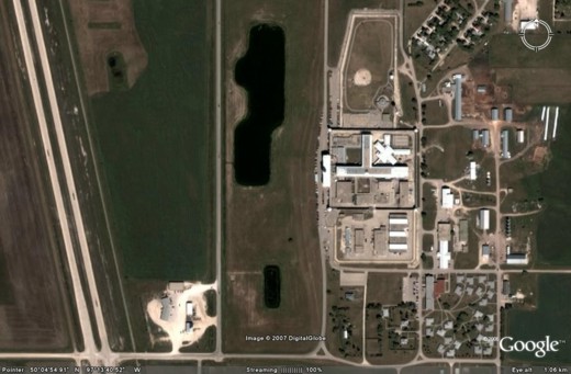
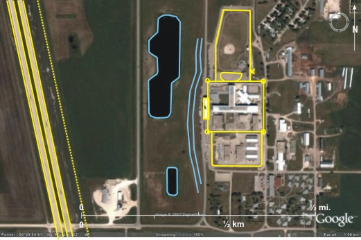
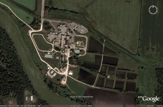
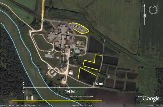
On the low land west of the gaol are two large ponds 11, and outside the enclosed areas are houses both on the northeast 12 and southeast 13 which might house workers at the gaol. The CP railway line 14 runs parallel to PTH 7.
[[fig. 19.15]]