Chapter 15: Industry/Manufacturing
Avery and 1) extraction industries, including oil drilling, rock quarrying, gravel pits, and mining. 2) processing industries which are divided into three: a) mechanical processing including saw mills, grain mills, ore concentration plants, hydroelectric plants, water purification plants, and sewage treatment plants; b) chemical processing including petroleum refining and production of chemicals; and c) heat processing including thermal electric plants, cement production plants, and iron production plants. 3) fabrication industries which involve the “use of the output of processing industries to form or assemble finished products.”[iii] Examples are production of structural steel, shipbuilding, and locomotive and car production. These are the most difficult to identify on air photographs because activities are hidden from view in well-constructed buildings and enclosures. Not all of these industries are found in Manitoba, but a few examples are shown here, and others have been shown in previous photos, for example, oil drilling (figures 13.11 and 13.12), gravel pits (figures 13.1 to 13.8), and mining (figures 13.9 and 13.10). Some activities associated with water—hydroelectric plants and sewage treatment plants—are included in the section on water resources. [i] Todd, D. “ [ii] Avery, T. E. and [iii] Avery, T. E. and
Notes
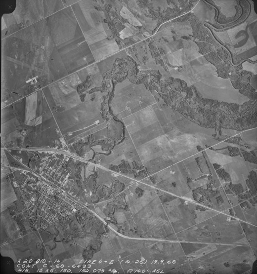
15.1: Oil Wells Near Virden
Oil production in
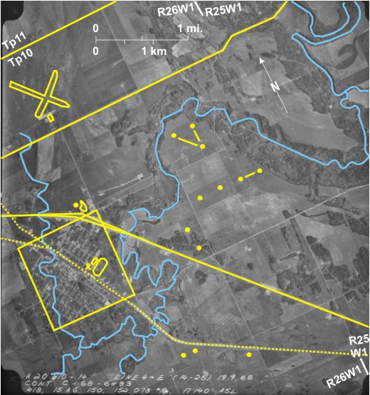
Despite the large number of wells they have little impact on the natural environment. The oil pumps take up only a few square metres of land with slightly more being used where oil and saltwater storage tanks are located nearby.[iii] The surrounding land can be used for agriculture. Pumps are small enough that they are scarcely visible on air photos. However, a few are indicated 1; pipelines running between wellheads 2 often best pick them out.
The photo shows the town of
The CP railway line 8 runs southeast/northwest through Virden before splitting in the north 9. Roads in the town are parallel to, and at right angles, to the railway. The Trans-Canada Highway 10 is twinned 11 as it bypasses Virden to the north. PR 259 12, which crosses the Assiniboine River north of town, eventually joins the Trans-Canada Highway off the photo to the west.
Other features to note are the Virden airfield with grassed runways 13 and a terminal building 14; a drive-in cinema northeast of town 15; and a racetrack 16 with an associated arena 17 and curling rink 18 northwest of it.
[[fig. 15.1]]
15.2: Industry in Central and Eastern Winnipeg
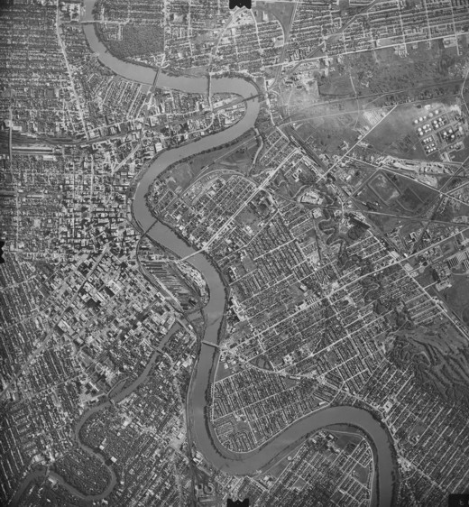
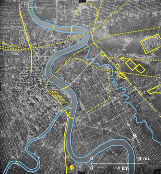
This old photograph shows the essential elements in the development of the city—the rivers and the railway lines—as well as some of the industry located in Saint Boniface, east of the
The wide
CN lines 16 enter from the east, join in north Saint Boniface 17, cross the Red downstream from The Forks 18, and then spread out into railways at The Forks 19. Two bridges 6 carry lines across the
In addition to these national lines the Greater Winnipeg Water District line 23 follows the direction of the aqueduct that carries water to
The Saint Boniface industrial area, located mainly east of the
The Saint Boniface area includes several large buildings 25, some of which are probably grain elevators clearly related to the railway lines; in at least two cases 26 rail cars can be seen drawn up beside the buildings. Evidence of two other industries is visible. In the extreme east is the St. Boniface Oil Refinery 27 (no longer in operation); oil storage tanks 28 (white, circular) are seen in the west with the refining area in the east 29. Here a flare stack is producing smoke which drifts westwards 30 on an easterly wind. Another large oil storage tank 31 (circular, dark grey) is located west of the refinery. Finally on the extreme eastern edge of the photo are the sheds and holding pens 32 of the Saint Boniface Stockyards.
[[fig. 15.2]]
15.3: Industry in Eastern Brandon
On this photo the eastward-flowing Assiniboine River 1 is seen in the north. South of it is the Canadian Pacific Railway line 2 that spreads out into sorting yards in the west 3. A roundhouse can be seen 4, as can numerous railway cars both east 5 and west 6 of the First Street Bridge 7 that crosses both the railway line and the river. In the past the upkeep of this bridge in the City of
In the south is the CN line 10 that runs diagonally through section 13, township 10, range 19WI, a large part of which has been designated as an industrial park (
The most obvious feature in the section to the east (18,10,18WI) is a large chemical plant 19, Koch Fertilizer Canada Ltd., which manufactures mainly potash fertilizer. The plant receives raw materials on a spur from the CN line 20; several cars can be seen on it 21. Within the plant round storage tanks can be seen 22 as well as several long narrow buildings 23. Two conveyor systems are seen in the south 24, and a transformer station is located in the northwest corner 25. Worker’s cars are parked on the south side of the plant 26, and to the east is a reservoir 27 which might contain waste from the plant.
Also located in 18,10,18WI are two auto wrecker’s yards; one immediately west of the chemical plant 28 and the other in the northwest corner of the section 29. Just north of the latter is a large group of electrical transformers 30. A large irregular gravel pit, exploiting the gravels of the upper Assiniboine Delta, is located in the northeast 31.
[[fig. 15.3]]
15.4: Chemical Plant and Thermal Electric Power Station East of Brandon
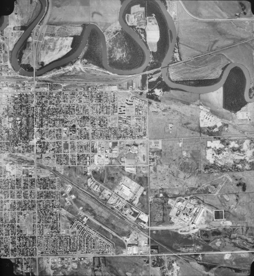
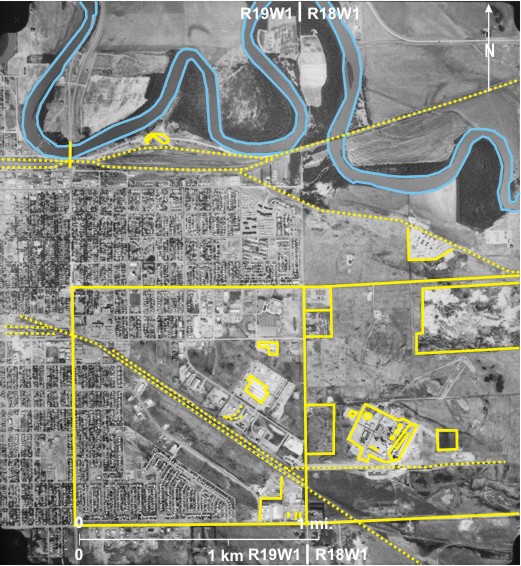
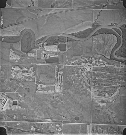
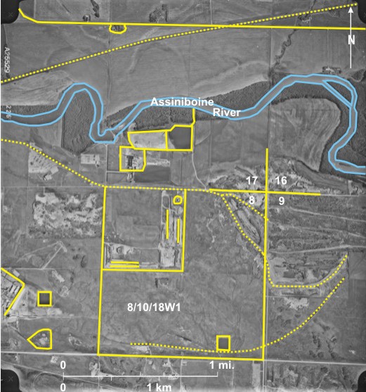
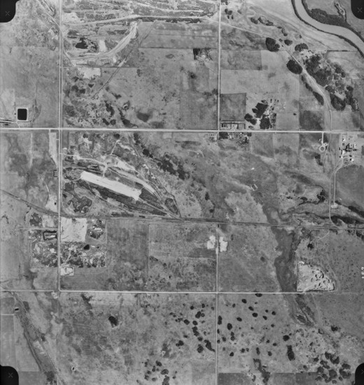
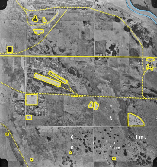
This photo is an extension eastward of Figure 15.3 at a slightly larger scale. In the southwest is the chemical plant seen in figure 15.3 1 with some slight differences; for example the square reservoir (#27 on figure 15.3) does not exist, but south of the plant is a reservoir 2 created by a dam 3. The reservoir empties eastward onto wasteland. Also different is the fact that part of the gravel pit in the northeast of 18,10,18WI is now flooded 4.
In the north the CPR line 5 crosses the eastward-flowing Assiniboine 6 with the Grand Valley Historical site (the original
The railway line continues east 21 and splits at 22 before running into a complex area of gravel pits in the northeast corner of 8, 10,18WI 23. Section 8,10,18WI appears to be occupied mainly by wasteland, but in the centre is a shelterbelt 24 that surrounds an abandoned farmhouse. In the south is a disused railway line 25.
[[fig. 15.4]]
15.5: Industry in Eastern Brandon
Dating from 1970 Brandon’s city boundaries extend far to the east of the built up area, providing space for industry and associated developments which are not deemed desirable for residential areas.
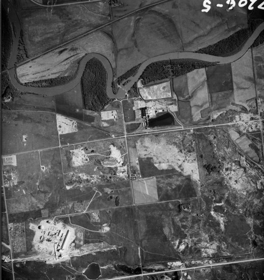
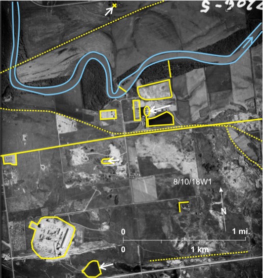
This photo is centred further east than figure 15.4, but many of the same things can be seen: the chemical plant in the west 1, the thermal electric plant further north 2, and the CP line 3 with the Grand Valley site to the north 4. But some changes can also be seen. The square reservoir shown on figure 15.3 (#27) 5 exists here as does another further east 6. The more circular reservoir (#2 on figure 15.4)—full on figure 15.4—is empty here 7. Also the reservoir north of the power plant has been extended eastward, and the newer part is now full 8; as well, a new discharge line has been cut through the woodland to the
Section 8, township 10, range 18WI has changed considerably. In addition to the new reservoir in the southeast corner 6, the city’s dump now occupies the northwest quarter 10. North/south 11 and east/west 12 pits have been excavated and will eventually be filled with garbage. The circular feature in the northeast corner 13 is not identified.
A complex of gravel pits occurs at the intersection of sections 8, 9, 16 and 17 14. The railway line that serves the power station continues into this area 15, and another further south 16 is now abandoned. In the north, PR 457 17 links
[[fig. 15.5]]
15.6: Brandon From the East
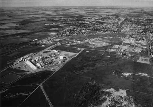
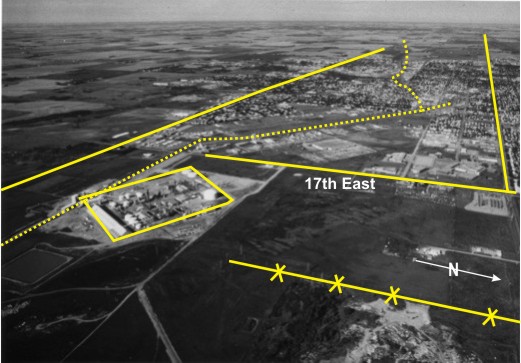
This photograph, a high oblique so called because the horizon is showing, was taken looking west along Victoria Avenue 1 with Richmond Avenue 2 on the left (south); both are true east/west roads. In the foreground (left) is Koch Fertilizer Canada Ltd. 3 with the Green Acres Industrial Park 4 to the west on either side of the CN railway line 5. In the foreground is a power line 6 running to the Koch Fertilizer Plant from the thermal power station just off the photo to the right (north). At the junction of Victoria Avenue and 17th Street East 7 is Assiniboine Community College 8—one of two institutes of higher education in the city, the other being Brandon University. In the middle ground are the residential areas of
[[fig. 15.6]]
15.7: Gravel Pits and Chemical Plant in Eastern Brandon
This photograph of the extreme eastern part of
This area situated near the apex of the Assiniboine Delta is an excellent source of gravel. Spurs from the CN line 7 run into two long (light-toned) gravel pits 8. Pits are also located in other areas; some—light-toned—appear to be active 9 whereas others are overgrown and therefore have a patchy dark tone 10, and others are filled with water 11.
In the extreme east is a chemical plant 12 close to the
In addition to the industry there is some evidence of agriculture. Dugouts 19 suggest livestock grazing in this area with permeable soils developed on sand and gravel.
[[fig. 15.7]]
15.8: Duck Farm in Cornwallis, Southeast of Brandon
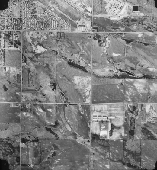
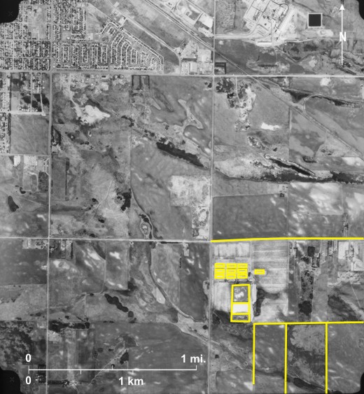
“Industry in
Also of interest on the photo are some gravel pits not seen on previous photos. These pits that are usually light-toned 4 are depressed areas and should not be confused with other light-toned elevated areas 5. The latter result from rain splash erosion of soils; usually they have less well-defined boundaries than gravel pits.
Aside from these features it is worth noting the irregular section line between sections 6 and 7, township 10, range 18 6. Another somewhat unusual feature in this part of
[[fig. 15.8]]
15.9: Forestry Industry in The Pas
The forestry industry in Manitoba is relatively minor compared with many other provinces; in 2002 Manitoba and Saskatchewan produced only two percent of Canadian lumber and a recent map[i] of Canada’s sawmills shows that only three in existed in Manitoba in 2002. A small one near Steinbach processes mixed woods, and two larger ones in
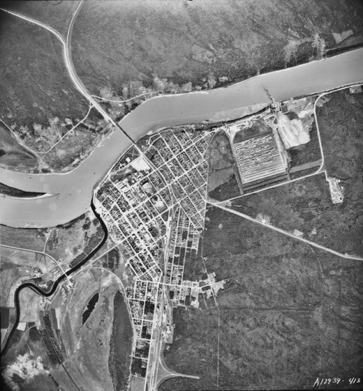
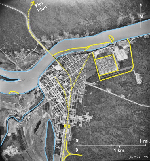
This old photo of The Pas shows the location of a wood processing plant. The wide, light-toned, sediment-laden Saskatchewan River 1 flows from west to east, emptying eventually into
The CN line enters the city from the south 4, crosses the
[[fig. 15.9]]
15.10: The Pas in 1973
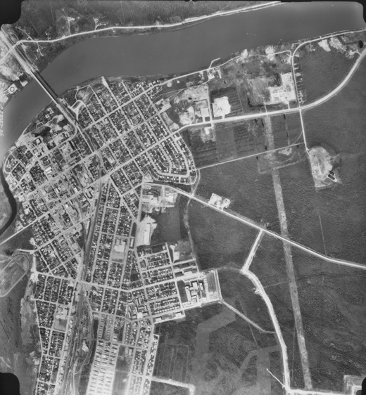
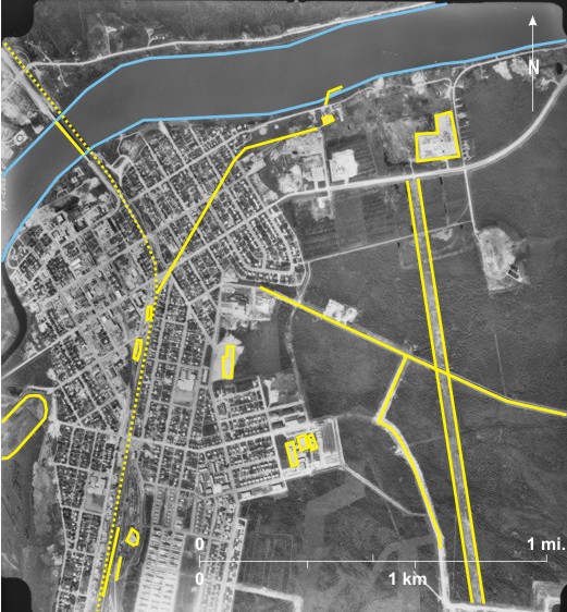
This newer, slightly larger-scale photo of The Pas illustrates the usefulness of an increase in scale to detect details and of sequential photos to detect changes.
In the south railway cars on sidings 1 and a round house 2 are clearly visible. Further north a long building with railcars beside it 3 can be seen with the railway station (dark-toned) 4 north of that.
Additions since figure 15.9 was taken include a race track north of Halcrow Lake 5, a long narrow building three blocks east of the railway line 6, and a series of large buildings southeast of that 7. The last is Keewatin Community College[i] which was at the time one of three community colleges in Manitoba, the others being Assiniboine Community College in Brandon and Red River Community College in Winnipeg. In the east a cleared area through forest 8 is followed by a power line leading to transformers 9 in the area where the wood processing plant used to be (#11 on figure 15.9). The railway spur leading to the plant still exists 10, leading to a narrow light-toned building 11. The forestry industry has not deserted The Pas but the processing plant is now located outside the city.
Other changes include a new road bridge 12, west of the railway bridge 13 across the
[[fig. 15.10]]
15.11: Forest Fires in Northern Manitoba
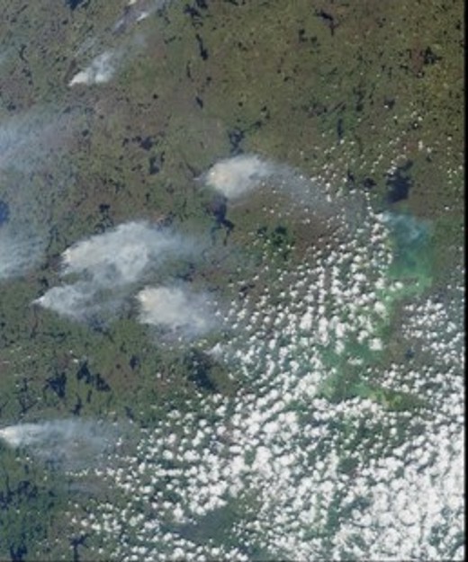
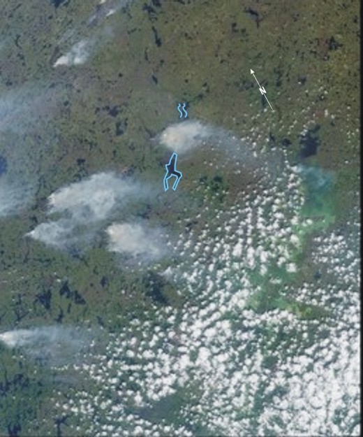
This image obtained on June 20, 2001 shows numerous smoke plumes from fires caused by lightning strikes. The area covered measures 232 kilometres by 80 kilometres. Tufty cumulus clouds 1 obscure Southern Indian Lake. The large plume 2 northwest of
This area is included in the open lichen woodland vegetation zone where “better drained upland ground cover is dominated by light coloured fructicose lichens between scattered spruce.”[iii]
[[fig.15.11]]
15.12: Forest Fires over Northwest Manitoba, June 2006
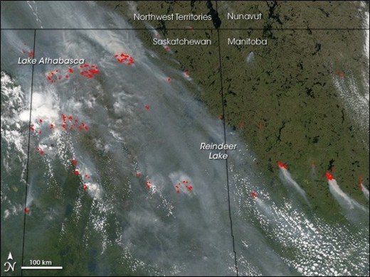
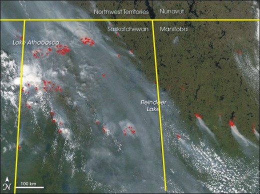
This satellite image shows forest fires over northwest
[[fig. 15.12]]
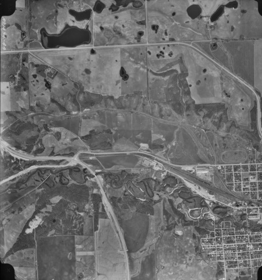
15.13: Location of an Ethanol Plant at Minnedosa
“Ethanol can be produced from any biological feedstocks that contain sugar, or materials that can be converted into sugar, such as starch or cellulose. In
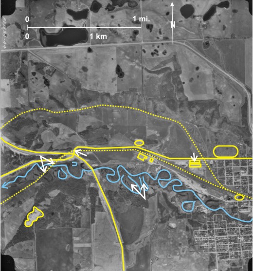
The photo shows the western part of Minnedosa 1, located in the valley of the west-flowing Little Saskatchewan River 2. The ethanol plant 3 is located west of town on the north side of the Little Saskatchewan River. Nothing on the photo indicates that it is an ethanol plant. However, it is located on a railway line 4 that has many rail cars 5 on it, and it is located in a suitable wheat growing area. A similar building is located north of the railway line 6. At the date the photo was taken, the buiding was a distillery; it was not until 1980 that it became an ethanol plant that was taken over by Husky in 2000.
Other things to notice on the photo are 1) the Little Saskatchewan River has numerous cutoffs 7; 2) PTH 10 8 bypasses the town to the west and intersects PR 355 9; 3) the CP railway line runs through Minnedosa 10 and angles up the steep north side of the Little Saskatchewan valley 11; 4) a spur from the main line leads to the ethanol plant 12, and a round house 13 is located near the junction of the two lines; 5) the spur line used to continue west to the edge of the photo, but now it does not cross PTH 10 14 and PR 355 15, nor is there a bridge across the river 16 although the line can be seen on both sides 17; 6) a racetrack is located in the western part of Minnedosa 18; and 7) two gravel pits can be seen, one in the southwest 19 and the other north of the ethanol plant 20.
15.14: Delete this figure
Delete