Manitoba Pageant, Winter 1975, Volume 20, Number 2
|
In 1877 Lord Dufferin visited the Icelandic settlement at Gimli, Manitoba. In writing about this visit to the colony in his The Icelandic People of Manitoba, W. Kristjanson states that Lord Dufferin’s party made many visits to the homes of the villagers “... as well as three farms two miles to the west, along the road which the colonists had built in the spring.” However, neither the names of the farmers nor the location of their farms are given. No specific mention is made of the “road the colonists had built.”
The purpose of this essay is to establish the route followed by Lord Dufferin at Gimli to visit the settlers, the farms he may have visited and the location of the “old Icelandic road.”
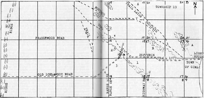
Those who are acquainted with the town of Gimli may conclude that to reach farmers two miles west of the village only two routes were possible: (1) the present road west leading to Fraserwood and passing by the airport or, (2) the road one mile to the south parallel to the Fraserwood road. It is the opinion of the writer that neither of these two routes was followed. Therefore, it will be necessary to, first, disprove that either of the two roads could have been used and then show a possible alternative.
The first route would have been along the road passing the airport. One does not have to travel far from the C.P.R. tracks on the way to the air-port to observe that the road crosses a ravine (letter “A” on the above map). This spot was impassable. Even in the memory of the writer the grade was washed out at least twice—once from heavy spring runoff and once, in 1923, by a cloud burst on the 7th of July. A swamp one mile west of the ravine is designated by “B”. No road could have been built along this route in the spring of the year.
The second route would run west a short distance from where the Gimli Hospital is located at present. This is the line between sections 8 and 17. This was also an impossible route. A traveller may even now locate marshy land (marked “C”) where Highway No. 8 cuts this road. Therefore, the Icelanders would not have attempted to build their first road through a marsh.
Having eliminated both of these routes, the writer is of the opinion that the route followed and the road that the Icelanders built ran along the line due west from the lighthouse towards the location of the C.P.R. depot and then followed the height of land which runs west through section 17 and part way through Section 18. Section 18 was cut diagonally by a freshet which had two large beaver dams: one at a point “E” and the other at “D”. This watershed seemed to have been part of an old river. It would have been difficult to cross it where it left the NW¼ of 18 and entered the SE¼ of 18 unless it was a dry year. However, this obstacle was easily overcome by continuing a short distance to the northwest and crossing the freshet by way of the beaver dam at “D” and from there continuing in the southwestern direction along a fairly pronounced ridge of dry land. Once the SW¼ of section 18 was reached the distance travelled would be two miles west from the village of Gimli.
There is other evidence, indirect as it may be, to re-enforce the assumption that the Icelandic road ran through the middle of sections 17 and 18 west of the village of Gimli which is located on the west part of section 16, township 19 and range 4 east of the principal meridian in the Province of Manitoba. (The east part of section 16 is Lake Winnipeg). In 1907 my father, Wasyl Ewanchuk, bought the NW¼ of 18-19-4E from an absentee landowner, A. E. Kristjanson, for $1200. From my parents I gathered the information that in 1907 the house was demolished and only a sheep pen and an old hog barn remained. This area was clearly demarcated and the location of the house was on higher ground. For years afterwards pieces of lime, crockery and rotted wood from the foundation would be ploughed up. The buildings were not set closely to the Fraser-wood road but well into the section. The spot is marked by the figure “2”. A road ran due south to the beaver dam at “D” and then in the southwesterly direction through SW¼ farmed in the early days by Adam Haas who later moved to Landis, Sask. I remember asking my father about this road and all the information he gave was that this was the road used by the Icelanders to travel between farms.
The buildings on the SW¼ farmed by Adam Haas were located in the extreme southwest corner. But on the hummock which stretched to the west and also in the easterly direction towards the village there were clear demarcations that farm buildings were once located on this site. My brother and I used to herd cows along the range line between sections 13 and 18 and draw water from the old well located close to where the farm buildings appeared to have been (“3” on map). We also found remains of old lime and mortar foundations across the range line on SE¼ of section 13 directly in line with the old site on the Haas farm. This quarter was not occupied in those days. There was a road cut through the bush running towards the southwest and I remember well that this road came from the east and was clearly visible through the brush and the willows crossing over into my father’s farm and running parallel to the fence line. The area of the foundations and the well on the SE¼ of 13 is shown by number “4” and the direction of the road is indicated.
The west half of the SE¼ of 18 before it was bought by Zachary Lenchuk belonged to Gusti Paulson. On this land there was a frame house, a two-storey structure painted rusty red. This house, too, was set very close to the middle of the section (marked by figure “1”) and along the road leading to the village. This must have been the “old Icelandic road.”
There were several trails that should receive consideration. A road which ran through our farm emerged from the northwest of the SE¼ of 24, crossed the range line, cut across the corner of SW¼ of 19, then across NW¼ of 18 and continued into the middle of the section. This is indicated as trail “W”. Trail “V” emerged from the NW¼ of 24 and entered NW¼ of 13. Trail “Y” also came from section 24 and by crossing section 19 continued towards the village. Trail “X” was a footpath and was in use until circa 1930. Since there were many sloughs, swamps and marshes created by beaver dams the trails ran along higher land each in the direction of the village. People had to avoid the quagmires such as existed at “A”.
It is interesting to note that the trails radiated from the village in the north-western direction towards the ridge which cut across sections 27 and 26. It seems that the trails were developed by the Icelanders who in the early days settled to the north in Vidir and Sylvan districts. They could travel to Gimli by the ridge, which was used as a partial highway until recent times, and then cut across to the village. However, all the trails seem to run towards the line running through sections 17 and 18 and not along what is now called the Fraserwood or the airport road. This seems to support the assumption further that egress to the west was through the middle of the section 17 and that this was the “old Icelandic road.”
An incident comes to mind in reference to Trail “W”. This must have been the trail that was used by the Indians on their trapping excursions to the north from the St. Peter’s reserve. The incident must have taken place before 1920 for we still lived in the log house. One autumn night there was a knock on our window while we were all asleep. My father went out and found that Indians wanted to spend the night on our yard. Evidently they were travelling along Trail “W” from the north. The older man was quite indignant that my father had erected fences along the trail. He claimed that this was a well-established road. In the morning we saw the Indians load their wagon drawn by two red oxen. Mother gave them a loaf of bread and they started towards Gimli. The women and the children rode on the wagon, (One boy was blind.) The numerous dogs followed and three men riding Indian ponies brought up the rear.
Since all the trails led to the line running through the middle of sections 17 and 18, this must have been the road the Icelanders built by cutting a trail through the bush in the spring of 1877. This road, in the opinion of the writer, led to the ridge five miles to the west. By this ridge it was possible to reach Stonewall and Selkirk during the winter and before the Lake became open for navigation in the spring. This must have been, therefore, the trail followed by Lord Dufferin and his party to visit the farmers two miles to the west. Consequently, I wish to call it the Lord Dufferin Trail at Gimli.
Although the writer has not the information with respect to the farms visited, it seems that Lord Dufferin and his party left the village along a road directly west of the present location of the C.P.R. depot and followed a line until the middle of section 18 was reached. After visiting the homestead No. 1, they continued to the northwest until homestead No. 2 was reached. From homestead No. 2 the party went to the south and crossed the slough by way of beaver dam at “D” reaching homestead No. 3. It is not likely that homestead No. 4 was visited as the settler and his family would come to homestead No. 3 to meet Lord Dufferin. Homesteads 3 and 4 must have been visible from each other as this seemed to be a natural clearing. In the month of September this area would create a fine impression on Lord Dufferin. These three farms mentioned would, therefore, be the ones visited by Lord Dufferin. One of these was later to become my father’s farm. This establishes the Lord Dufferin Trail in Gimli.
After completing this essay the writer was able to get further evidence that corroborates the conclusions reached. It was possible to contact Zachary Lenchuk who now lived in Camp Morton, Man. His daughter writing on his behalf supports the location of the old Icelandic road and the fact that it ran to the west to the ridge.
Dr. V. J. Kaye in his recent book, Early Ukrainian Settlements in Canada: 1895-1900 on page 241 quotes a report written by Leon Roy about Township 19, Range 3 East, who describes Sections 21, 22, 23, and 24.
“... The soil in this section is excellent. I have marked out (blazed) a trail from this land between Sec. 21-16, 22-15, 23-14 and between 9 and 16 to a road partly cut out leading to the Village of Gimli.”
A glance at the attached map will show clearly that the Lord Dufferin Trail when projected would meet the trail blazed by Leon Roy between Sections 9 and 16, and that this was the old Icelandic road. It is also interesting to note that the trail was not cut between Sections 13-24. Had there been a road west of Gimli between Sections 17-20 and 18-19 then surely another mile of trail would have been cut to meet this road. It seems that due to the swamp at “F”, trail “V” was used and it led to the Icelandic Road and Lord Dufferin Trail.
Page revised: 20 July 2009
