by Kathleen Sinclair
Manitoba Pageant, Winter 1970, Volume 15, Number 1
|
History is people! This was emphasized for members of the Manitoba Historical Society during their field trip south of the border on the weekend of June 21-22. The trip was arranged through the cooperation of the Manitoba Historical Society and the Red River Valley Historical Society.
On a pilgrimage such as this, we would have been lost without competent local guides. We would have seen and recognized the familiar prairies - the treeless plains, green and flat, stretching to the horizon, but we would have missed the historic river crossings, the old cart trails and historic places. We would have recognized the ribbons of trees, marking the winding courses of rivers and streams, the aspens and willows growing in ordered rows - the shelter belts of the farm homes, but we would have missed the museums and the pioneer buildings. The more observant would have noted the wild roses blooming earlier in North Dakota than in Manitoba. The spectacular displays of peonies around homes in town and country alike were a colorful reminder that summer is fairly rooted in North Dakota earlier than in Manitoba.
As the tour went on, it became obvious that without the devotion of informed historians along the route and at various sites, much of interest in our common history would have been lost. As for an early centre of communication, who would have recognized an enormous tree on a river bank as a post office, used by United States military forces one hundred years ago? Mr. Albany Capistran knew all about it and passed on his knowledge to eager groups of listeners.
Among those who made history live for us were W. D. Syverson, Gordon Gunness, Pat Goggin, D. B. Allen, Leo Kjellerup, Mrs. A. Smith, and Carl Peltoniemi, as well as Mr. Capistran. The historical information commit-tees were headed by Mr. L. E. Olson and Mrs. A. J. Christopher. All these well informed people seemed to have an inexhaustible knowledge of the history of their respective districts, a thorough grasp of the economic and social problems facing their own communities, and all were most generous in sharing their knowledge with us.
Mr. Capistran joined us first on Saturday morning at Fisher, Minnesota, and was our guide as far as Crookston. At Fisher's Landing, [1] the former end of steel, we saw through Mr. Capistran's eyes the terrain as it had been when his great-grandfather settled there. He reviewed the changes thereabouts in modes of travel and land use, in farming methods and crops sown, all of which had gradually come to head since the days of pioneer settlement. Before leaving Fisher we made an enjoyable stop at the Legion where Mrs. Capistran and friends were waiting to regale us with coffee and delicious little cakes. This was our first experience with the combined ingredients of history and hospitality. It was most enjoyable.
The brief stop at Crookston included our first visit to a museum. Here one of the inescapable facts of guided tours became apparent to museum lovers; they do not provide enough time for browsing. The large museum, a two-storey brick structure, was full of originally laid-out displays. The first of several pioneer schools, saved from oblivion by the imagination and foresight of local historians, was preserved here.
At Georgetown, [2] site of the southermost post of the Hudson's Bay Company, we were joined by Mr. W. D. Syverson who took us on a trip to the 100-year-old Probstfield house and steamboat landing.
Gordon Gunness, succeeding Mr. Syverson as guide at Abercrombie, took us for a tour of the state park at Fort Abercrombie, [3] where the highlights included a tour of the grounds and the recently constructed block-houses. Here another fine museum was housed in its own new building. Mr. Gunness, like Mr. Capistran, is a successful farmer as well as a lucid historian.
Our next guide, D. B. Allan, reminded us of one of Canada's prominent citizens and outstanding politicians - Joey Smallwood of Newfoundland. He was equally personable, and his encyclopedic knowledge of the Wahpeton area and of its history was fascinating. For many listeners, his most astounding utterance was that he was 80 years old!
In Wahpeton we gazed with mixed feelings at the junction of the Ottertail and Bois de Sioux rivers - the source from whence the Red River draws its waters. Here there is an excellent museum which deserved more time than we could give it. We were only able to slowly circle the interesting exhibits, coffee-cups in hand.
During the most southerly leg of the trip, with Leo Kjellerup as guide, history had to compete with scenery as we drove along Lake Traverse. Our terminus, Browns Valley, was highlighted by more wonderful hospitality; (this time lemonade and brownies) and local history. The state monument to Sam Brown, [4] his ancient log house and pioneer school, all received close inspection.
Only a narrow height of land [5] divides Lake Traverse and its northward flowing waters from Big Stone Lake and its southward flowing waters. Here the Minnesota River starts on its way to St. Paul.
For many of us the climax of the two-day tour came just before we left Browns Valley, when one of our gracious hostesses, Mrs. Arthur Smith, came aboard our bus and distributed small pink floribunda roses. These had been taken from a bush in her garden which, as a small cutting, had been clipped from a bush planted in Ontario by Laura Secord. Mrs. Smith is descended from Laura Secord, and so it was impressive to find these direct links with Canada in Browns Valley, Minnesota.
Proudly wearing these lovely flowers, we finally arrived at Peter's Sunset Beach, a resort on Lake Minnewaska, Glenwood, Minnesota. Here is another community where the quality of the exhibits in the museum was paralleled by the enthusiasm and knowledge of the guides who showed us through after a late supper.
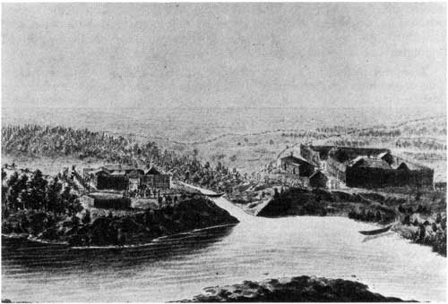
The above sketch by Peter Rindisbacher (1822) shows Fort Daer (left) and Pembina Post (right) at the confluence of the Red and Pembina Rivers.
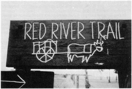
This marker near Wadena, Minnesota, and others like it, shows the places where old Red River Trails are intersected by modern roads and highways.
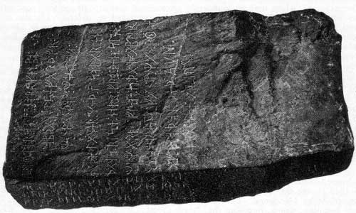
Going north on Sunday morning, our first stop was at Alexandria, Minnesota, where the museum containing the Kensington Stone [6] was opened early for our benefit. This controversial stone has been thoroughly bebunked by many outstanding authorities; some people support it with enthusiasm and others with qualifications. If, however, its runes [and they are of mixed vintage] could be satisfactorily sorted out, authenticated, and defined, then some of the early history of central North America - Manitoba, Minnesota, and the Dakotas - would have to be rewritten.
We returned to history of a more recent date with our arrival at Wadena, where our guide, Carl Peltoniemi, showed us traces of the Crow Wing Trail. [7] Mr. Peltoniemi and his two sons accompanied us to Park Rapids where a former lumber camp is now operated as a nationally famous restaurant. At Lake Itasca we saw an unpretentious trickle - the tiny headwater of the mighty Mississippi - starting on its long journey to the Gulf of Mexico.
Pembina, our last stop, again featured history and hospitality, coordinated by Mrs. A. J. Christopher, the mayor's wife. We visited the twin museums (Barry and State) at Fort Daer. [8] Here we saw the building used as the first masonic lodge in the northwest; here also we saw the log dwelling used as a pioneer school from 1871 to 1875. Refreshments were served in the parish hall of the beautiful new Roman Catholic Church, the fourth to be built on the site where Father Dumoulin [9] established his mission in 1818.
After a trip like this in which history and hospitality were so enjoyably merged, what impressions linger? Initially, for Canadians who were concerned with the Centennial of Confederation in 1967, for those who are now concerned with the centennial of Manitoba in 1970, and the centennial of Winnipeg in 1973, our interest in preserving the memory of the collective ethnic pasts - Ukrainian, Mennonite, or whatever it may be - seemed distinctly out of place south of the border. There was no such emphasis apparent throughout our tour; its absence probably implying a difference in philosophy, as expressed in the melting pot and mosaic theories of nationalism. The second lasting impression, and probably the most important - the dedication of our hosts - proved that history is people and that its preservation depends on people like our hosts - and ourselves!
1. Fisher's Landing, Minnesota
Fisher's Landing on the Red River in Minnesota was the end of steel in the north-west before the St. Paul, Minnesota and Manitoba Railway, (J. J. Hill's line), later to become the St. Paul and Pacific, was completed to St. Boniface in 1879. The Pembina Branch in Manitoba, from Emerson to St. Boniface and then to Winnipeg was operated by the Canadian Pacific Railway.
Fisher's Landing has many associations with Manitoba by virtue of the stream of trade and settlement which flowed through that place from St. Paul and thence by sternwheel steamboat to Winnipeg. On one particular count, perhaps above all others, Fisher's Landing merits a high place in the memory of Manitobans.
It was to Fisher's Landing that the first shipment of wheat for export was consigned on October 21, 1876. The small but significant shipment of 857 bushels was placed on board the sternwheeler Minnesota at the foot of Lombard Avenue, and on a frosty morning late in October it reached Fisher's Landing, just forty-eight hours before ice closed the river for the winter.
"Farmers and millers in Ontario liked the hard spring wheat and asked for more. A quickened interest in the province which produced such grain resulted in a flood of immigration. 'Manitoba, No. 1 Northern' became a magic phrase on the world's grain markets." - City of the Rivers, Queen's Printer, Legislative Building, Winnipeg.
2. Georgetown The southernmost post of the Hudson's Bay Company in Rupert's Land was located on the present site of Georgetown, Minnesota.
"The new ideas and the new committee [HBC 1863] were slowly turning away from the Bay and towards the prairies. Simpson had moved in this direction, and Dallas had followed him, with experiments in the re-organization of the Company's transport system to mark the change of emphasis. Dallas was not satisfied with Simpson's experiment of getting goods up to Red River from St. Paul. and he tried for improvement by getting the Grand Trunk Railway to ship direct from Sarnia to Superior City, from whence the goods would go via Georgetown to Fort Garry" - Hudson's Bay Company, E. E. Rich, p. 847.
It was 28th April [1869], all the same, before the Company's store was open for business [at Upper Fort Garry]. Mactavish's health mended with better weather, and the clerks worked well. But it would have been contrary to their habits, and to the whole tradition of the Company, to have opened shop before the long inventory was completed and the accounts checked. The delay was marked by considerable tension and drunkenness, and Riel recovered a good deal of popularity when he ordered the Union Jack to be flown at the Fort despite secessionist protests. Then, with the store open, the Company printed and issued pound notes, and then five shilling notes, five pound notes, and even ten pound notes. The river opened up and the Company's steamer, the International, took her first load of furs for Georgetown ... ' - Ibid, pp. 930-31.
A United States military post established in 1858 near the head of navigation on Red River. It was a major link in a chain of posts extending from St. Paul, Minnesota, to Montana and the western goldfields. It afforded protection for the northwest frontier, and travellers on trail or river, on their way to Red River Settlement, welcomed its stout stockade and blockhouses as symbols of defence against the Sioux. However, in spite of this salutary prospect, the fort was besieged by the Sioux in 1862, but was successfully defended by volunteer troops, the regulars having been withdrawn for service in the American Civil War.
"Above the mouth of Wild Rice r., Fort Abercrombie was established pursuant to A. of C. [Act of Congress], March 3d, 1857, and orders from hdqrs of the army, June 24th, 1857, at a point on the W. bank of Red r. 12 m. N. of the confluence of Bois des Sioux and Otter Tail rivers, the intention being to build near the head of navigation, 'in the vicinity of a place known as Graham's Point, Minn.' ... Lt. Col. J. J. Abercrombie arrived on the spot Aug. 28th, 1858, and troops were quartered for the winter of 1858-59. The post was abandoned July 25th, 1859: re-occupied July, 1860; attacked by Sioux, Sept. 3d and Sept. 6th, 1862; building finished in Feb., 1863 . - The Manuscript Journals of Alexander Henry, Elliott Coues. See his notes pp. 147-48.
In the fall of 1869, William McDougall, Governor of Rupert's Land, had three hundred rifles packed in twelve cases, waiting at Fort Abercrombie to be moved across the border to arm the Canadians at Red River. Riel knew this, and so on November 2nd, the same day McDougall was banished from the country, the metis seized Fort Garry and there, among other things, took possession of 390 rifles and thirteen six-pounder cannon. Fifteen years later the Government of Canada paid the Hudson's Bay Company ten thousand pounds for goods taken by the metis and for expenditures the Company had been forced to make during the Riel occupation.
Samuel Jerome Brown, affectionately known in Minnesota and North Dakota as the "Paul Revere of the Frontier," made an epic 150-mile ride through the Dakota Territory on the night of September 26, 1866, to alert scouts and warn settlers of a suspected Indian raid. After it was all over, he called it a wild-goose chase, because the report which prompted it was false. Later in life, reminiscing on the ride, Brown said: "I contracted injuries which deranged my eyes, dimmed my eyesight, paralyzed my muscular powers, deprived me of the use of my legs, of all the natural power of motion, and permanently impaired my general health, the same having been super-induced by over exertion and exposure to cold and wet."
Samuel Brown was the son of Joseph Renshaw Brown, a distinguished pioneer of Minnesota, founder of Browns Valley settlement, from which the city of Browns Valley takes its name. The long, narrow depression, known as Browns Valley, is the reservoir for Lake Traverse, which, with its tributaries, is the source of Red River - Adapted from Valley News, Centennial Edition, 1966, p. 3.
In the spring of 1820, three Mackinaw boats, having been transported across Wisconsin, were launched in the Mississippi at Prairie du Chien. Thence, by the Minnesota River, they reached Big Stone Lake, from which point they made a traverse across the Height of Land on rollers to the shore of Lake Traverse in Browns Valley. Northward from here they proceeded to Red River and the Red River Settlement. Each boat was manned by three men, and the total lading of the three boats was 200 bushels of wheat, 100 bushels of oats, 30 bushels of peas.
This is the only instance on record of a heavy shipment being transported the entire distance by water from Prairie du Chien to Red River Settlement, except for the traverse of the Height of Land above Browns Valley which separates the south-eastward flowing tributaries of the Mississippi from the northward flowing tributaries of the Red. - Ibid, p. 1.
The reason for this trip to Wisconsin and return is given as follows by W. L. Morton: "The locusts deposited their eggs in the colony [Red River Settlement], and the following spring [1819] the young were at work early in May. This time they stripped the plots, and even the prairie, so that there was little grass for hay. Not only was no grain left for food, but little or none for seed. Seed had from time to time been obtained from posts on the upper Assiniboine, [notably from Brandon House], and from Bas de la Riviere on the Winnipeg River; these had escaped the locusts. In 1820, however, it was necessary to send a party down to Prairie du Chien [on the Mississippi] in Wisconsin Territory to buy seed wheat. It returned with two hundred and fifty bushels in early June, and much of the late sown wheat matured sufficiently to escape fall frosts. From this wheat came most of the seed of the colony thereafter, and the strain was known as Prairie du Chien" - Manitoba: A History p. 57.
A stone bearing a runic inscription, said to have been discovered on a farm near Kensington, Minnesota, in 1897, and inscribed as follows: "8 Goths [Swedes] and 22 Norwegians on exploration journey from Vinland westward. We had camp[ed] by two skerries [island, rocky isle, or reef], one day's journey north of this stone. We were and fish[ed] one day. After we came home [we] found 10 [of our] men red with blood and dead AVM [Ave Virgo Maria] save [us] from evil. [We] have ten men by the sea to look after our ship[s] fourteen day's journey from this island. Year 1362."
For denial of this stone and its inscription see Tryggvi J. Oleson, "The Early Voyages and Northern Approaches," pp. 102-5. Quote, in summary: "Brought to the attention of runologists, it [the Kensington Stone] was immediately pronounced a forgery ... which may be confidently pronounced a nineteenth century concoction and whose authenticity not one runologist has ventured to defend." On the other hand, for a vigorous defence of the stone, see various works of Hjalmar R. Holand, including Westward From Vinland, New York, 1940; Exploration in America Before Columbus, New York, 1956; A Pre-Columbian Crusade to America, New York, 1962.
One of the trails leading from Red River to St. Paul. Professor W. L. Morton says it was opened in 1844 for bringing in American goods to Red River. He says it was less exposed to stoppage by the Sioux than the older trails down the west bank of Red River. Reverend George Bryce, in a talk recorded in one of the early transactions of the Manitoba Historical and Scientific Society, says the trail was on the east bank of Red River and was opened in 1844 by William Hallett after he had been attacked by Sioux on his way to St. Paul by Lac Traverse and St. Peter's. The trail had to be cleared for many miles through dense wood, and its chief disadvantage over the west bank was the many fords that had to be made across numerous streams. - Hamilton, "In The Beginning" p. 63.
Named after a subsidiary title of the Earl of Selkirk, and built late in the autumn of 1812 by the first party of Selkirk Settlers [indentured servants] under the leadership of Miles Macdonnel. The fort was situated at the southwest junction of Red and Pembina rivers, opposite the North West Company's Pembina Post which stood on the northwest junction. The HBC's post was on the east bank of Red River across from Fort Daer. It was to Fort Daer that several successive parties of settlers went each fall to spend the winter near the buffalo, the source of fresh meat and robes, returning each spring to Point Douglas to build homes and barns and plant crops and gardens.
When John, Lord Daer, died in 1796, Thomas Douglas, the youngest and last of seven sons, became Lord Daer and his father's heir. Three years later when the old Earl himself died, Thomas Douglas became Baron Daer, Fifth Earl of Selkirk, head of the house, and inheritor of responsibilities and privileges he had not dreamed of five years before. - Adapted from Lord Selkirk of Red River, John Morgan Gray, pp. 15-16.
"... his [Macdonnel's] first crops turned to little profit, provisions could not be got, and through the summer of 1813 Fort Daer was almost abandoned and at Point Douglas little would have been accomplished if Peter Fidler, from Brandon House, had not supplied pemmican, surveyed the lots (each with a river-frontage) for the settlers and even provided a bull, a cow and heifer. Even so, the produce of 1813 was not enough to see the settlers through the next winter. Macdonnel therefore had to take almost all the settlers to winter once more at Fort Daer, hoping that buffalo would again supply food.
By comparison with his first winter, Macdonnel found that of 1813-14 a " 'terrestrial Paradise' at Fort Daer, for both fur companies had withdrawn their posts from Pembina and provisions came in regularly and without rancour." - Hudson's Bay Company, 1670-1870, E. E. Rich, pp. 318-19.
The trouble was that Pembina lay south of the 49th Parallel and was within American territory, as laid down by the treaty of 1818. Halkett, in his journey from the States, [1822], had given orders for the colony's outpost at Fort Daer to be abandoned. This was part of his general conclusion that nothing could be made of Lord Selkirk's title to lands south of the frontier, and he regarded the whole attempt to claim lands south of the 49th parallel as `an unfortunate establishment.' " - Ibid. p. 430.
"At the instance of Lord Selkirk and his Catholic lieutenant, Miles Macdonnell, Fathers Norbert Provencher and Severe Dumoulin and Teacher William Edge arrived at Fort Douglas from Montreal in 1818. But that fall, at the request of the colonists, who were forced by hunger to move to Pembina, and of the metis hunters already settled there, Father Dumoulin went to Pembina and built a church. His congregation was about three hundred, six times as large as that at Fort Douglas ..." - Strange Empire, Joseph Kinsey Howard, p. 50.
Kensington Stone - for translation of runic characters see here.
Page revised: 23 May 2011