by Clara Norquay
Manitoba Pageant, April 1961, Volume 6, Number 3
|
The great body of water that pounds upon the northeast shores of Manitoba is of vital importance because it makes the Keystone Province an important maritime province also.
Hudson Bay is a large body of inland water, surpassed in size only by the Mediterranean and the Baltic Seas. It is approximately 850 miles in length and some 500 to 600 miles in width. Our part of its 2,000 mile coast line runs from the 60th parallel of north latitude to about half-way between the mouth of the Nelson and Albany Rivers.
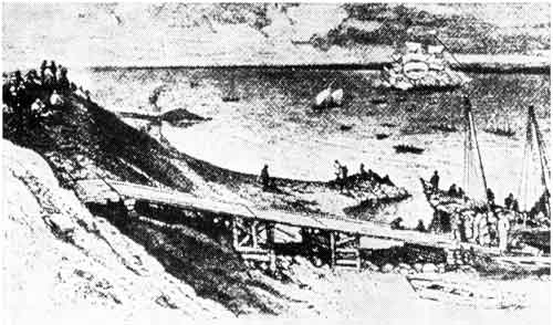
Hudson's Bay Company ships arrive at York Factory, 1815.
Source: Archives of Manitoba
The Hudson Bay drainage basin is larger than any other in Canada. Practically the whole central plain and much of the Canadian Shield are drained by river systems which empty into the Bay.
It is a body of water remarkably free of rock and shoal. Deep water is found near the islands and a deep channel runs down the centre of James Bay. The depth is quite uniform, averaging seventy fathoms and deepening to one hundred as it enters the Hudson Strait. The Strait connects the North Atlantic to Hudson Bay by a five-hundred mile tortuous channel, from thirty to one hundred miles in width.
The current of the Bay itself, although affected by the rise and fall of the tides and by the currents of the mighty rivers entering it, runs south along the west coast, east across the mouth of James Bay, then north along the east coast into the strait.
Seventy miles off Churchill a magnetic field is encountered where the compass is never constant; the soundings here, fortunately for mariners register sixty-eight fathoms to a gravel bottom.
Hudson Bay does not freeze over, but the harbours and inlets freeze from ten to thirty miles beyond the shore. When this ice breaks from the shore it is called "raft ice." It drifts with the current and joins with other raft ice to form "Pans" of ice. The heavy Arctic ice and bergs rarely enter the Bay but are carried by the currents between Salisbury and Nottingham Islands into the Strait where it can cause much trouble and delay in navigation.
Storms in the Bay are frequent. Snowflurries and hail storms are experienced at any time, even in the summer. Fogs rise when large bodies of ice are close. The prevailing summer winds are east-northeast. Summer temperatures are moderate and pleasant, but winter readings are low and the winds are strong. Wind chill is killing. With modern methods of weather forecasting, new modes of heating, new materials for winter clothing, balanced and adequate supplies of food, and modern transportation, life can be fairly comfortable. What a contrast this is to the hazardous experiences of those who opened up this Hudson Bay route.
Page revised: 1 July 2009