by Douglas Kemp
Manitoba Pageant, Volume 3, Number 3, April 1958
|
The opening of the West for settlement had been among the forces which led to Confederation, and the young Dominion of Canada, stirred by a sense of urgency, embarked somewhat precipitately on plans for carrying it out. The premature application of these plans resulted in the Red River Resistance of 1869-70. The events of this movement caused a temporary delay, but on 15 July 1870 the Dominion took possession of Rupert’s Land and the North West Territories on transfer from Great Britain and on the same day the little Province of Manitoba began its legal existence. The way was cleared for a new start on the plans. As they developed, the West was provided with a government, a start was made on a transcontinental railway, treaties were made with the Indians, a civil police force, the North West Mounted Police, was established, and a system of survey was introduced.
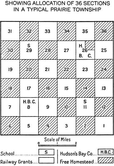
It is about a feature of this system of survey that we will concern ourselves but before going on with that let us look briefly at the system itself. It was adopted on 1 March 1871, and after a slight revision on 25 April 1871, it was put into effect. The system was rectangular with townships 6 miles square consisting of 36 sections of 1 mile square (640 acres) each. The sections were divided into 4 square parts known as quarter sections. The latter was the unit offered virtually free to the settler or homesteader. The International Boundary, the 49th parallel of latitude, was the base of townships 1 and 2 and east and west lines between townships 4 and 5, 8 and 9, and so on were base lines or standard parallels in the system.
Plan of a township showing disposition of lands (original).
The Winnipeg Meridian or First Principal Meridian, run in 1869, was continued as the meridian from which each tier or range of townships east and west was numbered. The longitude of this meridian is about 97 degrees 27½ minutes west of Greenwich. The Second Principal Meridian was established at 102 degrees west and successive meridians were established at 4 degree intervals. Township ranges west of the Second Principal Meridian are all numbered west from the appropriate meridian. It was and, of course, is possible to locate any piece of property by reference to the International Boundary and the appropriate meridian. For example, SE¼ 19-8-16W. 1st refers to the south east quarter of section nineteen in the eighth township north of the International Boundary and in the sixteenth range west of the First Principal Meridian.
Every effort was made to avoid errors in conducting the survey and periodically refinements were introduced to make the survey as perfect as was possible. In keeping with this practice, plans were made in 1873 for a most important adjunct to the general survey system; a Special Survey of meridians and bases in the North West Territories. It had been found that, in projecting the general survey, errors were occurring for which there were no readily applicable means of control available. A survey employing more refined processes was required and the Special Survey was designed to fill the need. The Survey would provide a check upon the work already completed and would serve as a basis for the extension of the township system to meet the need of isolated settlements which might spring up in advance of the general survey. The Special Survey served the latter purposes fully, and it is for these services that the Survey takes its place among the more important aspects of the settlement programme in the North West.
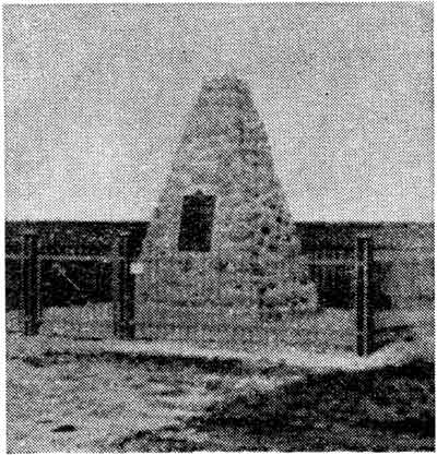
Monument on Principal Meridian near Headingly, Manitoba.
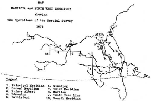
In 1872, Lindsay Russell, later to be in charge of the Special Survey, in co-operation with the Chief Astronomer to the British members of the International Boundary Commission had established, by telegraphic signals, the difference in longitude between the astronomic station on the 49th parallel at Pembina and the Observatory at Chicago. The first work of the Survey in 1874 was to determine the longitude of the point of intersection of the Winnipeg Meridian with the International Boundary. Thus, with the known relative position of Chicago and Greenwich, and by reference to the Pembina station, the necessary connection of all subsequent surveys with Greenwich was established. When this work was completed, a start was made in carrying the Survey westward. In the absence of telegraph lines, required for receiving accurate time signals, the accuracy of differences of longitude depended solely on that of survey measurement and so it was necessary to employ an exacting method known as triangulation. At the end of the season, the Survey had been projected from the Principal Meridian west to the Whitemud River at Westbourne and east to Winnipeg.
In 1875, the Survey was projected by triangulation westward from the Whitemud River 145 miles to the 102nd degree of west longitude, the Second Principal Meridian of the survey system, and 112 miles of that Meridian was established. The difficulty of using triangulation in wooded or in flat country proved to be too great and it was necessary to proceed by means of a careful survey in the ordinary manner. By 1877, the Survey had been carried north and west to the Third Principal Meridian, 106 degrees west longitude, and the Meridian was carried north from the tenth base line to the North Saskatchewan River at a point just west of Prince Albert. It that year, a section of the Survey journeyed to Edmonton marking on the way 8 of the old trails between Battleford and that place.
The Survey had reached isolated settlements and, in keeping with its purpose, settlement surveys were projected in 1878. The Edmonton section completed settlement surveys at Edmonton and Big Lake and then proceeded eastward along the North Saskatchewan, taking traverses of the Fort Saskatchewan and Victoria settlements on the way. At Prince Albert it joined with two other sections of the Survey in projecting block survey outlines (a block was four townships) and running settlement surveys of Prince Albert and of St. Laurent nearby. A fourth section continued the tenth base line west 108 miles to the first meridian west of Battle-ford, then proceeded north to the eleventh base line and west along it to the Fourth Principal Meridian (110 degrees west longitude).
In the next two years, the Survey was carried west to the Fifth Principal Meridian by projection along the fourteenth base line and then south to the International Boundary. In addition, the Survey completed several exploratory surveys, marked many old trails and established 19 astronomical stations to be used as checks on the general survey as it advanced westward.
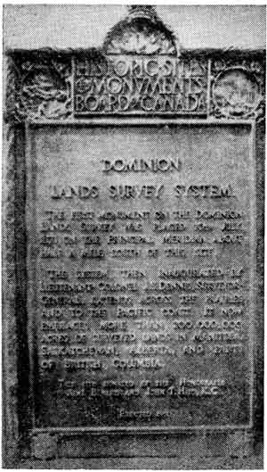
Plaque on monument on Principal Meridian
In six years, meridians and bases had been established from the Winnipeg Meridian to the Rocky Mountains and from the International Boundary to the North Saskatchewan River. The work, projected with the utmost care and precision, was to make possible the rapid expansion of the general survey which characterized the years 1880 to 1883. The more important settlements in the North West Territories had been surveyed, the old trails had been measured and marked for the convenience of the incoming settlers, and the Dominion Lands Branch, charged with settling newcomers, had received from the field reports important information regarding the topography and climatic conditions of a vast extent of territory. Much of the credit for the high standard established by the Dominion Lands survey must go to those who devised and carried out the Special Survey. Canada in pursuing its goal of opening the West was spared from the turbulent happenings that overtook parts of the United States and parts of Australia where settlers staked out their claims ahead of the surveyors.
More information:
Historic Sites of Manitoba: Principal Meridian
Page revised: 7 November 2010