by Alan B. McCullough
Ottawa, Ontario
|
In 1871, Metis inhabitants of Manitoba and white settlers, mostly from Ontario, both claimed the same lands along the Rivière aux Ilets-de-Bois (now the Boyne River) in south-central Manitoba. For much of that summer it seemed as though the conflicting claims might erupt into an armed confrontation, but, under pressure from Lieutenant-Governor Archibald, the Metis temporarily abandoned their claim, leaving the incoming settlers in possession of what came to be known as the Boyne Settlement. [1] The confrontations were an important event in the history of Manitoba but they were only one episode in the settlement of the area around present-day Carman. Prior to the confrontations, the area had been used seasonally by the Red River Metis who lived by hunting, trading, and subsistence agriculture. In the three decades after the confrontations, immigrants, primarily English-speaking Protestants from Ontario, developed the area along the river as a commercially-oriented farming community. On the northern edge of the Boyne Settlement, St. Daniel developed as a French-speaking, Roman Catholic, Metis community. The two settlements, differing in religion, language, and ethnicity, were similar in that both Metis and white settlers acquired Crown lands under the terms of the Dominion Lands Act and both, with varying degrees of success, developed as farming communities.
The stories of St. Daniel and the Boyne Settlement are illustrative of the broader history of Manitoba in the 1870s and 1880s when the Metis population struggled to adapt to a new political, social, and economic regime in which they were often a persecuted minority. For me, the local story has an added interest as my great-grandparents were among the Ontario settlers of the 1870s and 1880s. I grew up on a farm adjacent to the site of the original St. Daniel church and stories about the early Metis settlers, particularly John F. Grant, were a part of my father’s fund of local lore. This paper will build on the interest kindled by his stories. It is based primarily on census records from 1881 to 1901 with additional information from land records, parish registers, Metis scrip records, and Manitoba vital statistics. As well, three published histories of Carman and of Dufferin municipality and several short accounts of the St. Daniel settlement include first-hand accounts of the early days of the communities and a fund of information on the origins and experiences of the families who built the settlements. [2]
A word on place names may be useful. Prior to 1871 the Metis made seasonal use of the land along the Rivière aux Ilets-de-Bois (hereafter RIB), now the Boyne River. After this land was occupied by white settlers from Ontario in 1871, the Metis took up land about five miles north-west of the present town of Carman and built a chapel, which was first known as the Rivière aux Ilets-de-Bois mission and subsequently as St. Daniel. The core of their settlement was in Township 7, Ranges 5 and 6, which I will refer to as 7-5 and 7-6. The white settlers renamed the RIB the Boyne River and their settlement became the Boyne Settlement. Its core was in Township 6, Ranges 4 and 5 or 6-4 and 6-5. The Boyne Settlement was a part of the municipality and census district of Dufferin or North Dufferin. For most of the period, St. Daniel was in Dufferin or North Dufferin but in the late 1880s and 1890s it was in the Municipality of Elm River.
There were several means of acquiring Crown lands in Manitoba in the 1870s. Section 31 of the Manitoba Act set aside 1.4 million acres of land for Metis children. By the early 1880s, most of the younger generation of Metis settlers in St. Daniel had received title to 240-acre lots as their share in the Metis children’s “reserve”. The reserve lands were not in St. Daniel and it is probable that the grantees never actually occupied their lots; most Metis children’s allotments were sold, often before the patent was issued. [3] The government also issued scrip valued at $160 to Metis adults and to “original white settlers”. This scrip could be used to purchase Crown land, which, in the 1870s, was priced at $1.00 per acre. Section 32 of the Manitoba Act provided for the confirmation of land titles granted by the Hudson’s Bay Company before 1870; this applied primarily to river lots along the Red and Assiniboine rivers. Most of the Metis who were heads of families in 1870 and who subsequently took up land in St. Daniel and the Boyne Settlement received the $160 scrip allotment; some also received confirmation of their title to river lots occupied before 1870. Section 32 also provided that in areas where the Indian title had not been extinguished, persons in peaceful possession of land prior to the transfer could acquire the land by pre-emption. John F. Grant, a Metis, had occupied land on the Boyne River prior to 1870 and in 1883, he received a patent to the southeast quarter of 28-6-4-W1 as a Manitoba Act grant. His was the only Manitoba Act grant in the St.Daniel/Boyne Settlement area. After 1871, Crown land outside of the settled areas on the Red and Assiniboine rivers was granted under the Dominion Lands Act, which provided that the head of a family, or a single man 21 years of age or older, could acquire 160 acres of land by homesteading or purchase. With the exception of the Manitoba Act grant to John F. Grant, all of the land acquired by individuals in the Boyne Settlement and St. Daniel was granted under the terms of the Dominion Lands Act.
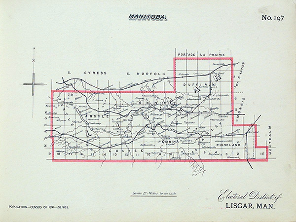
This 1891 map of the Lisgar electoral district shows the Dufferin Municipality with the Boyne Settlement at 6-4 and 6-5, and St. Daniel at 7-5 and 7-6.
Source: Library and Archives Canada, Ottawa: Government Printing Bureau, 1895, No.197, Lisgar
The Jobin family’s experience as landowners is typical of the Metis who settled in St. Daniel. Born in Quebec in 1831, Ambroise Jobin, Sr., married a Metisse, Margueritte Mondeville; in 1870, they were living in St. Charles parish with nine children. In 1876, Ambroise received scrip valued at $160 as an original white settler; Margueritte received scrip as a Metis head of family. In 1877, the government confirmed Ambroise’s title to 77 acres in river lot 55, St. Charles, and in 1880 it confirmed his claim to 94 acres in the outer 2 miles of lot 55. In 1879, patents were issued to each of the children for 240 acres as their share in the Metis children’s allotment. The grants were in the vicinity of the modern town of Starbuck. In 1877 Ambroise Jobin (whether Senior or Junior is unclear) acquired a quarter-section in St. Daniel using scrip. The same year Pierre Jobin, son of Ambroise, Sr., entered for land in St. Daniel as a homestead; he remained in St. Daniel until the 1890s. [4]
In general, Crown lands could not be granted under the Dominion Lands Act until they had been surveyed. When townships 6-4 and 6-5 were surveyed in 1872, the surveyors identified 15 individuals with claims in the townships and the same year four individuals applied for land as a homestead in 6-4. Fifty-six individuals applied in 1873 and 1874 and, by the end of 1881, 191 individuals had entered for land in the Boyne Settlement. Many entered for more than one quarter-section and, while others cancelled or modified their entries, nevertheless the entries made by the end of 1881 would result in the issue of patents covering 80% of the land in townships 6-4 and 6-5. [5]
St. Daniel, that is townships 7-5 and 7-6, was surveyed in 1872 and 1874. In 1875, six individuals entered for land in township 7-5. By the end of 1881, 68 individuals had applied for land in 7-5; of these, 52 would receive patents to at least one quarter-section. Six individuals entered for land in township 7-6 in 1881. [6] The surveyors made no mention of any claims or evidence of occupation or cultivation in townships 7-5 or 7-6, although the historians of St. Daniel report that the Metis had occupied land in the RIB area as early as 1860, had established a school at St. Daniel by 1866, and a chapel in 1870. In March of 1872, Archbishop Taché instructed Father Kavanagh to visit RIB for Easter; presumably this was because there was a Catholic population in the area although the surveyors had not recorded them. [7]
If the Boyne Settlement was settled slightly earlier than St. Daniel, it may have been because there was better access to water and timber and because the land was better. The surveyor of township 7-5 noted that it was too sandy for good agriculture, that the timber was mostly poplar, the best of which had been destroyed by fire, and that there was no water during the dry period. It was, he wrote, “a good country for the hunter”. A different surveyor rated the land in the Boyne Settlement much more favourably. Modern soil capability classifications rate almost all soils in the Boyne Settlement as class 1 and 2; whereas about 60% of land in the two St. Daniel townships is rated as class 3 or 4. [8]
Most settlers, Metis and immigrants, in the four townships acquired land by homesteading, sale, or purchase using scrip. In the Boyne Settlement, 36% of the land acquired by pre-1882 entries was granted as homesteads; 25% was purchased, 23% was acquired using scrip, and the remainder was acquired using Manitoba bounty grants, warrants and other means. [9] Of the 93 patents issued in 7-5 and 7-6 for land entered for before 1882, 43% were granted as homesteads, 14% were purchased, and 31% were obtained using scrip. Homesteading was less common in both settlements than it was in western Canada generally where 48.5% of all the Dominion lands granted prior to November 1880 were homesteaded; it is probable that the relatively low level of homesteading is reflective of the abundance of discounted scrip and bounty grants available in Manitoba in the 1870s. [10]
The land grant records do not provide any information on the ethnicity of the applicants for land. However, based solely on name recognition, it appears that of 191 individuals who applied for land in townships 6-4 and 6-5, prior to 1882, 176 were white and 15 were Metis. [11] Of these, 114 whites received patents to a total of 200 quarter-sections and seven Metis received patents to 17 quarter-sections. In townships 7-5 and 7-6, 37 of 72 individuals who applied for land before 1882 were Metis. Twenty-nine Metis received patents to a total of 43 quarter-sections and 28 white settlers received patents to a total of 51 quarter-sections. Generally speaking the Metis settled in the northern two-thirds of 7-5 and 7-6. [12] Fifty-two percent of the land acquired in the 4 townships by the Metis was homesteaded; for whites the figure was 37%. Twenty-one percent of land acquired by Metis was purchased; white settlers purchased 22% of their land. White patentees used scrip (essentially another form of purchase) to acquire land in 25% of all cases; Metis patentees used scrip for 21% of their acquisitions. The prevalence of whites as users of scrip is a reflection of the fact that much of the scrip issued to Metis in Manitoba was sold by the original Metis recipients.
Land patents typically gave the address and occupation of the patentee. All but three of the patents issued for land homesteaded in the four townships before 1882 gave the township as the patentee’s address. Among the patents that were not granted as homesteads, 26% of those in township 6-4, 36.5% of those in 6-5, and 30% of those in 7-5, were issued to individuals who were not living in the townships and who were not enumerated in the 1881 or 1891 censuses. Almost all absentee owners were white.
The Canada censuses for 1881, 1891, and 1901 provide information on the religion, birthplace, ethnicity, and occupation of the settlers of North Dufferin and Elm River. Over the three decades 50% or more of the heads of households [13] in North Dufferin were born in Ontario and between 20% and 30% were born in the United Kingdom. Manitoba-born heads of families were a small minority in North Dufferin but accounted for 30% of the heads of family in Elm River in 1891, and 36% in St. Daniel in 1901. In 1881 and 1891 over 90% of heads of family in North Dufferin belonged to various Protestant denominations. Protestants still accounted for over 85% of the population in 1901 with Roman Catholics accounting for about 14%.
The Roman Catholics were concentrated in the north in St. Daniel and in St. Claude, a settlement founded by Roman Catholic immigrants from France and Belgium in the 1890s.
It seems probable that the 1881 census failed to enumerate some residents of St. Daniel. The manuscript copy of the census does not provide addresses for households enumerated; however, information from land grants, the 1882 Henderson’s Directory of Manitoba and the North-West Territories, and local histories, make it possible to estimate the location of 155 of the 182 households enumerated. Keeping in mind the limits imposed by this approach, a minimum of 86 of the 182 households (47%) were in Townships 6-4 and 6-5. Only seven households out of 182 (4%) were enumerated in St. Daniel. Given that by the end of 1881, 72 individuals had applied for land in St. Daniel, I find it surprising that only seven households were enumerated there. There are possible explanations for the discrepancy. About one-third of the land applicants were absentee owners but 53 individuals were homesteaders who were required to spend at least six months of each year on their property. Homesteaders may not have wintered on their claim and consequently been absent when the census was taken in April and early May. As well, about two-thirds of the homesteaders in St. Daniel were Metis and some may have been absent on spring hunts. Four families who applied for land in 1881 but were not recorded by the census had children born at Wood Mountain and Fort Qu’Appelle in 1881; they may have been absent when the census was taken. [14] Church records suggest that there were more Catholics, and probably more Metis, in the area than were recorded in the 1881 census. In 1880, Father Kavanagh reported that there were 30 Catholic families at Rivière aux Ilets-de-Bois; the census identified only 10 Catholic households in North Dufferin. RIB was a mission of St. François Xavier and, in 1880 and 1881, the St. François Xavier priest recorded that 11 couples from RIB had children baptized at St. François Xavier. None of the couples was enumerated in the 1881 North Dufferin census although by 1881 eight of them had entered for land as a homestead. [15]
In addition to recording the birthplace of those enumerated, the census also reported an individual’s ethnicity or origin. Thirty-six per cent of the population were Irish in origin, 31% were Scottish, 19% were English and 7% were French. Most of those of French ancestry had been born in Ontario, Manitoba, and the United States; only a few were immigrants from Quebec. Although the 1881 census recognized “Indian” as a national origin, no Indians were enumerated in North Dufferin. The census did not recognize Metis as a category but, on the basis of name recognition and birthplace, nine heads of families were Metis; five of these were Protestant Metis living in the Boyne Settlement. If the settlers in St. Daniel were under-enumerated, it is likely that the number of Metis in North Dufferin was greater than reported.
The birthplaces and ages of parents and children provide evidence on a family’s history. Fifty-four male heads of household had been born in Europe but only 23 of the wives were European- born. Presumably, many of the heads of household had crossed the Atlantic as single men or boys and married in Canada. Only four Dufferin families had children born in Europe but a total of 55 families had children born in Ontario living with them in Manitoba. Published family histories provide details lacking in the census. For example, Thomas and Mary Booth emigrated from Ireland with one daughter to settle in Waterloo, Quebec. They had at least one child born in Quebec before moving to a farm in Perth County, Ontario, where another 5 or 6 children were born. The family then moved to Rhode Island to work in the cotton mills. When the mills closed during the American Civil War the family returned to Ontario and then, in 1871, they moved to the Boyne Settlement. Two of their sons-in-law, John Gray and Henry Rowe, followed them to Manitoba. In 1881, Thomas and Mary lived with two adult sons and two American born grand-children in Dufferin and two adult sons lived on nearby farms. [16]
Why specific families chose to leave Ontario is seldom clear. Ontario newspapers, led by Toronto’s The Globe, actively encouraged emigration to Manitoba. As well, at least one private organization, the North-West Emigration Aid Society, promoted settlement. [17] In Ontario, there was a feeling that “everybody was going west.” [18] The availability of farm land in Manitoba was an incentive to move. For example, seven North Dufferin families were from Wellington County in Ontario where, by 1871, 79% of the land was occupied. The average landholding in Wellington was only 97 acres and further division of existing farms was not an attractive prospect. A disproportionate number of settlers may have been renters before leaving Ontario; of 35 Ontario farmers who moved to the Boyne Settlement, and who can be identified in the 1871 census of Ontario, 34% were tenants. In Ontario as a whole only 15% of farmers were tenants. [19]
The 1881 census is not a reliable reflection of the Metis settlement of St. Daniel and should be supplemented with reference to the record of applications for land grants in 7-5 and 7-6. By the end of 1881, 33 Metis had entered for land in 7-5 and 7-6. Like many of the Ontario settlers, they were linked by family and place of origin. Thirteen were from St. Charles parish, five individuals came from St. François Xavier parish, and four from St. Norbert. Two individuals came from each of St. James and St. Vital and one from St. Boniface. In the years 1882 to 1898, 19 more Metis applied for crown lands; four of these were from St. Charles, four from St. Norbert, and three from Headingley. [20] Seven members of John F. Grant’s family and three McIvor brothers, one of whom was Grant’s son-in-law, took up land in St. Daniel. John Grant, Jr., married Marie Pruden whose three siblings, Charles, Thomas, and Nancy, also settled in St. Daniel. Four Aymond (or Emond) siblings and two Gagnon brothers came from St. François Xavier and four Ouelletes came from St. Norbert. These settlers formed the core of the St. Daniel settlement.
With the exception of John F. Grant, there is little direct evidence as to why these settlers chose to move to St. Daniel. In addition to being a merchant in St. Charles parish, Grant was a rancher; the unoccupied land in and around the RIB and St. Daniel suited the open-range style of ranching that he practised. Under Grant’s leadership the Metis of St. Charles had claimed the area along the RIB in 1871 as their share of the Metis children’s grant under the Manitoba Act; when their claim was ignored by Ontario settlers, St. Daniel may have been a known and acceptable second choice. Metis from other parishes were also familiar with the area along the RIB from the years before 1870. In his study of the Metis of St. François Xavier, Gerhard Ens concluded that those who left the Red River settlement before 1875 were pursuing the buffalo trade as well as avoiding the racism of the incoming Protestant settlers from Ontario. Those who left later, he suggests, had decided to farm and were looking for larger acreages than were available in the river lots of the Red River parishes. He identifies the Emonds, Delormes, Lillies, Prudens, and Gagnons as families who sold their river lots and took up land in St. Daniel. [21] To these families, I would add François Dubois, Pierre Dumas, André Guiboche, Ambroise Jobin, and Michel Proulx, all of whom had their title to river lots confirmed before applying for land in St. Daniel. [22] If the St. Daniel Metis were seeking to avoid the intolerance of the incoming settlers, the choice of land adjacent to the Boyne Settlement seems a strange one; perhaps it should be seen more as a determination not to be driven away from an area, which they thought of as theirs.
In 1885-1886, the government ordered a special census of Manitoba. Only the published report survives; it provides information on the sub-district of North Dufferin, which included the Boyne Settlement, and the sub-district of Elm River, which included St. Daniel. It is particularly useful because it identified Metis. In 1885-1886, Elm River had a population of 356 individuals in 86 families. Sixty-one percent of those enumerated in Elm River were Catholic compared to 4% of the population in North Dufferin. French Metis constituted 49% of the population in Elm River. English, Irish, Scotch and other Metis made up another 10% of the population. In North Dufferin, less than 2% of the population was Metis. [23]
In 1891, the Boyne Settlement was enumerated as part of Division 1 of the North Dufferin census sub-district; St. Daniel was included in the Elm River sub-district. In terms of settlers’ birthplace and religion, North Dufferin had changed little although it had grown from 182 to 300 households. Sixty-three per cent of the families were headed by farmers; this was down from 88% in 1881. The change was a result of the growth of Carman as a service centre. In 1881, 11 heads of households in North Dufferin had been identified as merchants, businessmen, or professionals. A railway was built to Barnsley, six miles north of Carman, in 1882 and was extended to Carman in 1889. The railway stimulated growth, and the 1891 census recorded 33 tradesmen, 28 merchants and businessmen, and 13 professionals as heads of family in North Dufferin.
Five hundred and sixty-five individuals in 117 households were living in Elm River in 1891; at least 51 of the households were located in townships 7-5 and 7-6, the core of St. Daniel. [24] Eighty-five percent of the heads of family were farmers; there were two storekeepers at Rathwell in the western part of the district. Based on name recognition, I have identified 47 Metis heads of household living in Elm River and 18 Metis heads of family in Division 1 of North Dufferin. [25] Fifty-seven percent of the heads of families in Elm River were Protestant; 43% were Roman Catholic. Of the 50 Catholic households in Elm River, 44 were Metis; six were French-Canadians born in Quebec and the United States; 33 of these Catholics can be identified as living in townships 7-5 and 7-6. They would have formed the core of St. Daniel parish; the 21 Catholic families in Division 1 of North Dufferin (including Carman) may also be counted as parishioners until at least 1893 when a Catholic church was built in Carman. [26] Of the 68 Protestant heads of families in Elm River, at least 19 lived in the southern half of the census district; their communal links were probably with the Boyne Settlement. Twenty-one Protestant families lived in the northern and western parts of the district closer to Rathwell and Indian Ford.
The 1901 manuscript census is unusual in that two schedules of the original census have survived. Schedule 1 includes a column headed “Colour” and enumerators identified individuals as “White”, “Red”, “Black”, or “Yellow”. Enumerators were directed to identify Metis as “Red” or Indian. [27] Schedule 2 includes the address and land holdings of rural residents; as a result it is possible to identify 90 households in 6-4, 56 in 6-5, 61 in 7-5, 31 in 7-6, and 297 in the village of Carman. [28] The population of the four townships, including Carman, had increased but in many respects its character had not changed. As a result of continuing immigration from Ontario, the townships’ roots were still solidly planted in Ontario where 61% of the heads of family had been born. Only 11% percent of the heads of family had been born in Manitoba and of these, 80% were Metis. Thirty-four Catholic Metis families lived in St. Daniel; 17 lived in Carman and one lived in township 6-4. Eighty-six percent of the heads of families in the four townships plus Carman gave English as their mother tongue and 11% spoke French.
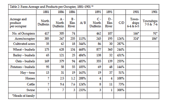
The Boyne Settlement and St. Daniel were agricultural settlements and, in the absence of other major sources of employment, the amount of land owned and the amount of agricultural product are important measures of wealth. In 1881, 83% of the adult males in North Dufferin were farmers. The published census report indicates that among the 464 families enumerated in Divisions 1 and 2 of North Dufferin, there were 417 “occupiers” of land. [29] Each occupier held an average of 385 acres; only 83 occupiers held less than 200 acres. Each occupier had an average of 35 improved acres and produced 175 bushels of wheat, 65 bushels of barley, 169 bushels of oats, 95 bushels of potatoes, and 13 tons of hay.
The censuses of 1885-1886, 1891, and 1901 allow us to trace the development of the agricultural economy in North Dufferin and in Elm River. Although most families in both census districts were occupiers of land, in 1885-1886, about 8% of families in North Dufferin and 14% in Elm River did not occupy land; in 1891 at least 13% of families in North Dufferin and 8% of Elm River families neither owned nor rented land. The higher percentage of landless families in North Dufferin in 1891 is explained by the fact that North Dufferin included Carman; there was no comparable urban centre in Elm River. [30]
The 1901 manuscript census allows a detailed comparison of individual occupiers/owners in Townships 6-4 and 6-5 (the Boyne Settlement, excluding Carman) and in Townships 7-5 and 7-6 (St. Daniel). Eighty percent of the heads of households enumerated in townships 6-4, 6-5, 7-5, and 7-6 were farmers. In townships 6-4 and 6-5, 146 household heads owned or rented an average of 324 acres of land each; 11 (7.5%) of the 146 neither owned nor rented land. In 7-5 and 7-6, 92 household heads owned or rented an average of 186 acres each; 20 (22%) of the 92, of whom 16 were Metis, owned no land. On average, the Metis in St. Daniel owned only 68 acres of land compared to 268 acres owned or rented by the white residents of St. Daniel. Only 12 Metis in St. Daniel owned 160 acres or more although 41 Metis individuals had received grants of 160 or more acres between 1875 and 1900. Most of the landless Metis in St. Daniel gave their occupation as “Labourer”, as did all of the Metis in Carman. In a farming community, land ownership is an indicator of wealth and the smaller amount of land owned by the Metis in St. Daniel is significant. [31]
In 18851886 and 1891, the average occupier in North Dufferin owned more land than the average occupier in Elm River. More critically, he (or rarely, she) cultivated about three times as many acres as an occupier in Elm River. The difference in cultivated acreage may reflect the number of years the different areas had been settled. Some of the differences may be related to topography: the St. Daniel district, particularly the northern portion where most of the Metis settled, was more heavily wooded than the Boyne district. Clearing land may have slowed bringing it into production. Cultural differences may also have been a factor. Most of the settlers in North Dufferin had a long farming tradition. Over half of the population of Elm River were Metis and although the Metis had some experience farming before 1870, they also relied on hunting, trading, and freighting and may not have been as focussed on farming as the Ontario settlers. [32]
Homesteading records support the view that the Metis farmed on a smaller scale than the Ontario settlers. Applications for patents under homesteading regulations recorded the number of acres the applicant had under crop at the time the application was made. Of 45 individuals who applied for patents three years after entry, applicants from 6-4 had, on average, 29 acres under crop and applicants from Township 6-5 had 24 acres. In 7-5, 10 Metis applicants had, on average, 11.4 acres under crop after three years; six white settlers had 24.5 acres under crop. [33]
The inhabitants of Elm River and North Dufferin grew wheat, oats, barley, and potatoes. In 1885-1886, 50% or more of the cultivated acreage was devoted to wheat and about 20% to oats; by 1891 the figure for wheat had risen to about 75%. The yield per acre was about the same in both districts but, because the farmers of Elm River had much less land in crop, they produced much less per occupier than in North Dufferin. [34] In 1885-1886, the ratios were about 1 to 5 for wheat and barley, about 1 to 4 for oats, and 1 to 1 for potatoes. In 1891 the ratios for wheat and oats were lower, about 1 to 2.5, but the difference was still significant. Wheat and barley were generally cash crops, destined for market, while oats and potatoes were more likely to be consumed on the farm; farmers in North Dufferin would have had more wheat and barley available for sale than those in Elm River. Given that the non-Metis in Elm River cultivated twice as much land per family as the Metis, the Metis production of grain per family would have been less than the average in Elm River. Between 1885-1886 and 1891, Elm River residents increased the number of horses and cattle they kept and doubled their production of hay. Both livestock and hay may have been produced for sale, thereby compensating for the lower production of grains in Elm River. Livestock could be pastured, and hay could made, on unoccupied Crown and railway lands. However, the supply of unoccupied grazing and hay land diminished rapidly in the decade before the First World War.
Housing can be an indicator of wealth and it can affect health. In Elm River, 102 dwellings housed 120 families in 1891; on average each dwelling had 5.6 inhabitants. In Divisions 1 and 2 of North Dufferin, 529 dwellings housed 530 families for an average of 4.5 persons per dwelling. Houses in Elm River were also smaller than those in North Dufferin; in Elm River 22% of dwellings were identified as “shanties”, 21% were one-room, and 29% were two-room buildings. [35] In North Dufferin, only 7% of dwellings were one-room and 24% were two-room buildings. None of the dwellings in North Dufferin was described as a shanty. The number of shanties and the proportion of one-room dwellings suggests a poorer quality, more crowded, housing stock in Elm River. [36] Houses in St. Daniel in 1901 were, as they had been in 1891, smaller than in the Boyne Settlement. In townships 6-4 and 6-5 the average house had 4.9 rooms with 5.4 inhabitants. In 7-5 and 7-6 the average household headed by a white settler had 3.3 rooms with 5.6 inhabitants; for houses headed by a Metis, the average was 2.2 rooms with 5.2 inhabitants. The smaller houses in Elm River may be an indicator of the relative wealth of the community; they may also have led to crowding with health consequences. [37]
A study of the parish of St. Claude, which adjoined the parish of St. Daniel, found that in the years 1892-1930 infant mortality, primarily due to tuberculosis, was higher among the Metis population than among the white population of the parish. [38] Mortality may also have been high among the Metis of St. Daniel. Manitoba’s vital statistics record 2498 births in Dufferin, North Dufferin, Carman, and Elm River between 1882 and 1901. Of these about 82% were white, 16% were Metis, and 2% cannot be identified. [39] The distribution of births between Metis and whites over the period 1882-1901 is in proportion to the distribution of population in the 1891 census in which 16% of families enumerated in North Dufferin and Elm River were Metis. In the same period, 1882-1901, 728 deaths were registered in Dufferin, North Dufferin, Carman, and Elm River. Thirty-one percent of the deceased were Metis, 67% were white, and 2% have not been identified as to race. The death rate for Metis is about double what might have been expected. [40]
St. Daniel and the Boyne Settlement were neighbouring but separate communities, divided by language, religion, race, and history. The Boyne Settlement began with the confrontations between Metis and Ontario settlers in 1871 and relations between the communities remained strained. John F. Grant commented in his memoirs, “...I knew the most of them were Orangemen for they did not like the Catholics.” He went on to say that after initial threats “... they never attempted to drive me away.” Grant also felt that, for the settlers from Ontario, “Nothing was right unless it was the same as Ontario”, and by 1891 he had “...tired of their bylaws”, and left the settlement. [41] An article in La Liberté et le Patriote in 1943 noted that the older members of the St. Daniel community remembered that there were “souvent querelles entre les deux groups, mais nos métis se faisant respecter.” [42] In 1885, the Metis of St. Daniel showed enough sympathy for the Metis of Saskatchewan that, when Archbishop Taché visited the mission he felt the need to speak to them in the “...language de la modération et de la paix....” Ambroise Jobin, Jr., who died of wounds suffered at the Battle of Batoche, was either the individual, or the son of the individual, who received a patent to land in St. Daniel in 1877. [43] The Orange Lodge, a Protestant fraternal order strongly opposed to Roman Catholic influence, was active in the Boyne Settlement; Orange membership was sufficiently large that a second lodge was organized in the western part of the settlement in 1883. [44] In 1885, the Boyne lodge was one of the many Canadian lodges that expressed its satisfaction with the execution of Louis Riel. [45] There was some interaction between the Metis and the settlers on the Boyne; Frank McDermott served on the Dufferin council from 1891 to 1900; John Grant, Jr., served as a trustee for McDermott School and as a pathmaster in Ward 6 of Dufferin Municipality. That both men were English-speaking may have been a factor in their integration into the larger society. [46] Nevertheless, given the tension and the religious divide between the two groups, it is not surprising that of 503 marriages recorded in Carman, Dufferin, and Elm River before 1902, at most 35 and perhaps as few as 10 were between Metis and whites; even fewer of these marriages crossed the lines of religion. [47]
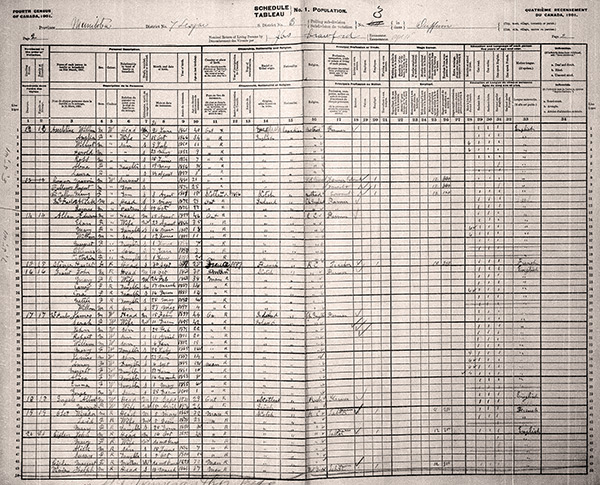
John Grant, son of John F. Grant, appears in this page from the 1901 census.
Source: Library and Archives Canada, 1901 census
By 1901, both the Boyne Settlement and St. Daniel had been occupied for over 20 years. In the Boyne Settlement, individuals had taken up about 95% of the land. There was little room for growth and the rural population remained stable between 1901 and 1906. In St. Daniel about 53% of the land in townships 7-5 and 7-6, had been granted to 102 individuals; 24% was reserved for the Canadian Pacific Railway and 5% for the Hudson’s Bay Company. With Crown land in short supply, the initial homesteading period of settlement in both the Boyne Settlement and St. Daniel was over.
Many of the early settlers were retiring from farming and a second generation was taking over. Of 261 individuals who had successfully applied for land in St. Daniel and the Boyne Settlement between 1872 and 1901, only 74 (31% of the white patentees, 21% of the Metis) were enumerated in the four townships and in Carman in 1901. Deaths would have accounted for many absences but even among the 34 individuals who applied for land after 1890, only 14 were enumerated in the 1901 census. Many of the changes in ownership may have been the result of an active market in land. For example, the northwest quarter of 16-7-5 was homesteaded by Daniel Frederic of St. Charles in 1879. He received the patent in 1882 and the same year sold it to a Métisse from St. Charles who sold it to Baptiste Ducharme, Sr., in 1888. In 1894, Ducharme sold an acre to the Roman Catholic Church and between 1895 and 1898 he sold small lots to his three sons and to his son in-law. In 1899-1900 when the church was moved to its new location, the Ducharmes sold their interests to James McCullough, an Ontario born settler who had arrived in the Boyne Settlement in 1874. [48]
As the Boyne Settlement filled up, families moved farther west. In 1905 Joseph Wells Johnston, who had arrived in Manitoba in 1870-1871, settled on the Boyne, and married a daughter of Samuel Kennedy, moved with his children and grandchildren to Vulcan, Alberta. [49] In 1907, the Dufferin Leader reported that 8 or 10 carloads of settlers’ effects were leaving for Hanley, Quill Lake, Edmonton, and Saskatoon. The departures included the second generation of families, which had been in the Boyne Settlement since the 1870s. [50] In spite of the departures the rural population in Townships 6-4 and 6-5 remained relatively stable and English-speaking Protestants remained the largest, and most politically dominant, group in Carman and Dufferin until after the Second World War.
There were also departures from St. Daniel as the population shifted north and west. St. Daniel School was moved 2.5 miles northwest in 1894; the church was moved about 5 years later. In 1902, the parish served 80 families of whom 64 were Metis. There was a settlement of 30 to 40 houses near the church and school where Joseph M. Aymont operated a store and post office. By 1910 only 33 families attended St. Daniel church and in 1911 Aymont moved his store to Haywood. [51] Some families moved farther north and west to Haywood and to St. Claude. [52] Other families with links to St. DanielMcIvor, Richit, Demarais, Pinette, and Lillywere enumerated near Ste. Rose du Lac in 1901. [53] After 1910, the parish stabilized as a Catholic community but it lost its character as a French-speaking Metis community. The 1921 census recorded 26 Roman Catholic families in townships 7-5 and 7-6. Of these 14 were Metis families and 12 were more recent settlers from France, Germany, and Quebec by way of Ontario. The use of French also faded; among 21 St. Daniel families, which were headed by French-speaking adults in 1921, three had children who did not speak French. By 1946, the parish priest in Carman reported that the Metis residents had “lost all their French” and had “gotten away from religion.” [54]
For some Ontario settlers, the move to Manitoba was notably successful. Rodmond Roblin moved from Ontario to Winnipeg and then to Carman in 1881; in 1900 he became Premier of Manitoba. Henry Ardington was born in Yorkshire in 1833. In 1852, he moved to Canada where he married Sarah Brown. By 1871, they were farming 100 acres of rented land in Peel Township. With four sons and three daughters, the problem of providing for their family must have concerned Henry and Sarah. In 1878, Henry moved to the Boyne Settlement, followed by his family in 1879. He and his four sons acquired land in the area and three daughters married local farmers. In an interview in 1894, he stated that after farming rented land in Ontario for 20 years he had been worth £200 but that after 15 years in Manitoba he was worth £6000. Ardington served on the first council of North Dufferin and when he died in 1901, he was the president of the Carman Farmers’ Elevator Company. [55]
There were fewer comparable success stories among the Metis of St. Daniel. John F. Grant was born at Edmonton in 1831, the son of Richard Grant, a white employee of the Hudson’s Bay Company, and Marie-Anne Breland, a Metisse and sister of Pascal Breland, a prominent Manitoba Metis. Grant became a successful rancher in Montana before moving to Manitoba in 1867. He established a home and store in St. Charles parish on the Assiniboine River and a mill and a ranch on the Rivière aux Ilets-de-Bois. Several of his children and sons-in-law were early settlers in St. Daniel. He speculated extensively in land and in the crash following the Manitoba land boom, he lost heavily. After the Municipality of Dufferin passed herd laws in the late 1880s the open-range style of ranching which he favoured became impossible and, in 1891, he and some of his family moved to Alberta. [56] At least three of Grant’s children remained in the Dufferin area and one, John Grant, Jr., continued farming the land in St. Daniel, which he had purchased in 1878, until the 1920s. Several of his children were still living in the area in the 1980s. [57]
There is no single answer as to why the Metis settlers of St. Daniel were less persistent than the white settlers of the Boyne Settlement. Both groups acquired their farms under the same administrative systemhomesteading and purchasing Crown lands; the Metis were slightly more likely to favour homesteading while the Ontario settlers favoured some form of purchase. The Ontario settlers, as a result of their success in the confrontation at the RIB, secured the better land; the Metis took up slightly poorer land around St. Daniel. In general, the Boyne settlers were quick to bring substantial amounts of land into production; the Metis settlers, who probably had a weaker agricultural tradition, were slower to bring their land into production. They produced less grain and probably had less income. This was reflected in smaller, more crowded, housing and possibly in poorer health. Finally, the Metis were a minority, divided from the majority by language, ethnicity, religion, and recent history; the prospect of moving to communities such as Haywood, St. Claude or Ste. Rose du Lac, where they would share language and religion with the majority, may have tipped the balance in deciding whether to go or stay in St. Daniel. In a small way, the experience of the St. Daniel Metis in leaving traditional lands was similar to that of the larger Metis population of Manitoba in the late 19th century.
1. Alan B. McCullough, “The Confrontations at the Rivière aux Ilets-de-Bois,” Manitoba History, Number 67, Winter, 2012. I will use the current English spelling, Metis, rather than Métis, to refer to both French-speaking and English-speaking descendants of marriages between European men and Indigenous women.
2. Thomas Kernighan, “The Brightest Jewel” as Seen Through the Eyes of Thomas Kernighan, np: Dufferin Historical Society, 2006; Carman Centennial Book Committee, Up to Now, Altona, MB: Carman Centennial Book Committee, 1967; June M. Watson, ed., The Rural Municipality of Dufferin, 18801980, Carman: Council of the Rural Municipality of Dufferin, 1982; Archives de la Societé Historique de St. Boniface (hereafter ASHSt.B), l’abbé J.-M. Gagné, “Conférences Données à la Radio CKSB, mars 1947 - La Paroisse de Saint-Denis de Haywood, Manitoba;” ASHStB, Anais Picton, “Short Historical Sketch of the Mission of Saint Daniel Formerly Known as Ilets de Bois;” Antoine Gaborieau, Ilets-de-Bois (St. Daniel) (np: np, June 2002).
3. Gerhard Ens, citing Douglas Sprague, states: “Of the 6099 patents issued to Métis children by 1900, 5260 were alienated.” Gerhard Ens, “Metis Lands in Manitoba,” Manitoba History, Number 5, Spring 1983. Ens references D. N. Sprague, “Government Lawlessness in the Administration of Manitoba Land Claims, 1870-1887,” Manitoba Law Journal, Vol. 10 No. 4 (1980). Table 1, p. 87.
4. D. N. Sprague and R. P. Frye, The Genealogy of the First Metis Nation: The Development and Dispersal of the Red River Settlement, 1820-1900, Winnipeg: Pemmican Publications, 1983; LAC, Canada Census, 1881, Manitoba, Selkirk, Assiniboia, p. 57; LAC, RG68, Western Canada Land Grants, 18701930, http://www.bac-lac.gc.ca/eng/discover/land/land-grants-western-canada-1870-1930/Pages/land-grants-western-canada.aspx; LAC, RG15, Scrip Records.
5. Watson, The Rural Municipality of Dufferin, pp. 1314, 1920; LAC, RG68, Western Canada Land Grants, 18701930.
6. Watson, The Rural Municipality of Dufferin, pp. 1314,1920. This includes seven quarter-sections patented to the Hudson’s Bay Company.
7. AM [Archives of Manitoba], GR126, Township Plan, 7-5; ibid,Township Plan 7-6; Gaborieau, Ilets-de-Bois (Saint-Daniel), pp. 3-5.
8. AM, Surveyor’s Notebook, #84, Township 7, Range 5; Canada, Sessional Papers, No. 7, 1873, pp. 4142; Agriculture and Agri-Foods Canada. “Soils and Terrain: an Introduction to the Land Resource,” Rural Municipality of Dufferin, Information Bulletin 9720, p. 21, Agricultural Capability Map.
9. Watson, The Rural Municipality of Dufferin, pp. 1314, 1920. The amount of scrip applied to land in the Boyne Settlement may be understated as I have not found any record of scrip being used to acquire land in 6-4. Manitoba bounty grants and/or warrants were issued to members of the militia who served in Manitoba.
10. Chester B. Martin, Dominion Lands Policy (Toronto: Macmillan Company of Canada, 1938), p. 142; Thomas Flanagan, Metis Lands in Manitoba, Calgary: University of Calgary Press, 1991, pp. 143153.
11. For name recognition I have relied on D. N. Sprague and R. P. Frye. The Genealogy of the First Metis Nation. I have assumed that Metis were born in Manitoba, the North West Territories or the United States. Most were Roman Catholic but some were Protestants. Individuals who were of French background and Roman Catholic, but who were not born in the West, would have formed part of the St. Daniel parish and may have identified with the Metis but they have not been counted as Metis unless they married Metis women.
12. Watson, The Rural Municipality of Dufferin, pp. 1314, 1920; LAC, RG68, Western Canada Land Grants, 18701930.
13. The census family was defined as a group of people who customarily took their meals together; often the census family included individuals who were not related by blood or marriage. I will use the term household where the census uses family and will use the term family for those related by blood or marriage. Department of Agriculture, Census Branch. Manual Containing The Census Act and The Instructions to Officers Employed in the Taking of the Second Census of Canada (1881), Ottawa: Queen’s Printer, 1881, p. 10.
14. LAC, RG15, Series D-II-8-c. Scrip affidavits for Celina Dubois, Joseph Lambert, Wilfrid Larose, and Eliza White.
15. ASHSt.B, FondsTaché, T2372425, Kavanagh to Taché, 22 April 1880. Parish records for St. Daniel or RIB were recorded in the Saint François Xavier registers. I wish to thank Gerhard Ens for this reference and for information drawn from the registers.
16. Watson, The Rural Municipality of Dufferin, pp. 345346; Carman Centennial Book Committee, Up to Now, pp. 1617.
17. Allen Ronaghan, “Charles Mair and the North-West Emigration Aid Society,” Manitoba History, No. 14, Autumn, 1987, pp. 1014.
18. Bella Blackburn’s response to the question “Why did you move to Manitoba?” in a survey entitled “Pioneer Days and Ways in Manitoba” conducted in the 1950s by the Historical and Scientific Society of Manitoba. AM, MG8, B62. Her family settled at Pilot Mound in 1879.
19. llustrated Historical Atlas of Wellington County, Ontario (Belleville: Mika Silk Screening Limited, facsimile reprint, 1972, [original 1906]), pp. 2-10. W. L. Marr, “Tenant vs. Owner Occupied Farms in York County, Ontario, 1871”, Canadian Papers in Rural History, Vol. 4, Donald H. Akenson (ed.), Gananoque: Langdale Press, Table 2.
20. Based on residence as it appeared in the 1870 census of Manitoba. Not all individuals can be identified.
21. Gerhard Ens, Homeland to Hinterland: the Changing World of the Red River Metis in the Nineteenth Century, Toronto: University of Toronto Press, 1996, pp. 170171; Gerhard Ens, “Dispossession or Adaptation: Migration and Persistence of the Red River Metis, 1835-1890,” in The Prairie West: Historical Readings, R. Douglas Francis and Howard Palmer (eds.), Edmonton: University of Alberta Press, 2nd ed., 1992, p. 154.
22. François Dubois, LAC, RG15, Vol. 1551, Reel C-11884, p. 118; André Guiboche, ibid., p. 81; Ambroise Jobin, Sr., ibid., p. 81; Michel Proulx, ibid., p. 80; Pierre Dumas, LAC, RG68, Liber 23, Folio 4-6, Lot 11, Microfilm Reel C-5958.
23. Census of Manitoba. 1885-86/ recensement de Manitoba (Ottawa: Maclean Roger & Co., 1887), p. xiv, Tables I-IV. The sub-districts covered the same area as the Municipalities of Elm River (Townships 7, 8, and 9, and Ranges 5, 6, 7, and 8, W1) and North Dufferin (Townships 4,5, and 6, and Ranges 3, 4, and 5.)
24. The manuscript census does not give the addresses of those enumerated; however, Henderson’s Manitoba and Northwest Territories Gazetteer and Directory for 1892... provides the post office address and address by section, township and range of 75% of the heads of families enumerated in North Dufferin, Division 1 and 64% of the heads of families enumerated in Elm River.
25. The enumerator for Elm River identified as French-Canadians individuals whom I would identify as Metis. The enumerator for North Dufferin identified three French-Canadian heads of households none of whom was among the 18 whom I have identified as Metis.
26. Watson, The Rural Municipality of Dufferin, p. 208.
27. Generally I have accepted “Red” as being equivalent to Metis. Canada. Fourth Census of Canada, 1901. Instructions to Officers, Ottawa: The Census Office, 1901, Paragraph 47.
28. LAC, Canada Census, 1901, Manitoba, Lisgar, Carman Village, C1, C2 and C3; ibid., Dufferin, B2, B3, B12, B13.
29. Schedule 4 of the census identified individuals actually occupying land in the community. Owners were recorded in Schedule 3; individuals recorded in Schedule 3 were credited with all of the land which they owned anywhere in Canada. Canada. Manual Containing The Census Act and the Instructions to Officers Employed in the Taking of the Second Census of Canada (1881), Ottawa; Department of Agriculture, 1881, pp. 4042.
30. Census of Manitoba, 188586, Table XIII; Canada. Census of Canada, 189091, Vol. II, Ottawa; Printed by S. E. Dawson, Printer to the Queen’s Most Excellent Majesty, 1893, Table XVI; Canada. Census of Canada, 189091, Vol. IV, Ottawa; Printed by S. E. Dawson, Printer to the Queen’s Most Excellent Majesty, 1897, Tables II and III.
31. LAC, Canada Census, Manitoba, Lisgar, Dufferin, B2, B3, B8, B12, B13, Schedules 1 and 2.
32. Ens, Homeland to Hinterland:, pp. 17274. F. Conrad, who lived in St. Daniel from before 1911, reported that the St. Daniel priest’s attempts to persuade the Metis to “till the soil” were “of no avail”. Carman Centennial Book Committee, Up to Now, p. 8. In her study of the Metis settlement of Saint-Laurent on Lake Manitoba, Nicole St. Onge suggests that a portion of the community with stronger links to a hunting and trading economy were slow to take up land and that some “apparently rejected...the habitant lifestyle.” (Italics in original.) Nicole St. Onge, Saint-Laurent, Manitoba: Evolving Métis Identities, 18501914, Regina: University of Regina, 2004, pp. 9293.
33. PAM, GR2060, Manitoba, Department of Natural Resources, Homestead Files, Reels M2242 and M2257.
34. Census of Manitoba. 188586, Tables XIII, XIV, and XV.
35. The census instructions referred to “shanties” as “dwellings of a temporary character, inhabited for only a part of the year.” Canada. Manual Third Census of Canada, 1891, p. 12
36. Canada. Census of Canada, 189091/Rencensement du Canada, 189091, Vol. 1, Ottawa; Printed by S. E. Dawson, Printer to the Queen’s Most Excellent Majesty, 1893, Table 2.
37. Canada. Census of Canada, 189091, Vol. I, Table II; LAC, Canada Census, Manitoba, Lisgar, Dufferin, B2, B3, B8, B12, B13, Schedules 1 and 2.
38. Michael Lucien Charles Rowan, “Saint Claude (Manitoba); a Demographic Analysis,” MA thesis, University of Manitoba, 1973, pp. 4849, 141.
39. Civil registration of births, marriages, and deaths began in 1882. The attribution of Metis and white has been based on name recognition.
40. Derived from Manitoba Vital Statistics Agency. http://vitalstats.gov.mb.ca/Query.php.
41. John Francis Grant, A Son of The Fur Trade: The Memoirs of John Francis Grant, Gerhard J. Ens (ed.), Edmonton: University of Alberta Press, 2008, pp. 264, 301
42. La Liberté et le Patriote, 6 January 1943, p. 2, “Notes historiques sur la paroisse de Haywood, Man. Les Ilets de Bois ou Saint-Daniel.”
43. ASHSt B, J.-M. Gagné, “Conférences données à la Radio CKSB, La Paroisse de Saint-Denis de Haywood, Manitoba,” mars 1947. First part, p.4. “Metis Killed During the 1885 Resistance.” http://www.virtualmuseum.ca/sgc-cms/expositions-exhibitions/batoche/docs/proof_en_those_who_died.pdf, accessed 30 April 2018.
44. Carman Centennial Book Committee, Up to Now, p. 93.
45. Le mot de la fin, voici le vote!: conspiration armée contre les Métis français: le chef Métis sacrifié aux Orangistes!: sa prétendue vénalité: légitimité du provisoire: ce meurtre de Scott!: l’opinion de quelques évêques sur le débat, celle des missionnaires: évêques et missionnaires: nouvelles indignités!: nouveaux griefs!: la folie de Riel. [1887.], p.8. http://peel.library.ualberta.ca/bibliography/1317/8.html
46. Watson, The Rural Municipality of Dufferin, pp. 85, 48485.
47. Derived from Manitoba Vital Statistics. http://vitalstats.gov.mb.ca/Query.php
48. Manitoba Land Titles Office, Morden, Old System Abstract Books, Township 7, Range 5, West 1st Meridian, NE-16-7-5.
49. Dufferin Leader, 2 June 1898, “Pioneer Days”; Vulcan and District Historical Society, Wheat Country: A History of Vulcan and District, Vulcan, Alberta: Vulcan and District Historical Society, 1973, pp. 557558.
50. Dufferin Leader, 18 April 1907, “Society Notes and General News.”
51. Watson, The Rural Municipality of Dufferin, pp. 163165, 18081, 198, 329; Gaborieau, Ilets-de-Bois (Saint-Daniel), pp. 68; LAC, Canada Census, 1901, Manitoba, Lisgar, Dufferin, B3, Schedules 1 and 2; ibid., B8, Schedules 1 and 2; ASHStB, Picton, “Short Historical Sketch...of Saint Daniel,” pp. 9, 13.
52. Rowan, “Saint Claude (Manitoba); a Demographic Analysis,” p. 67.
53. LAC, Canada Census, 1901, Manitoba, Ochre River, sub-district 1, pp. 1, 10; ibid., Ochre River, sub-district 2, p. 3.
54. LAC, Canada Census, 1921, Manitoba, District 29, Subdistricts 4 and 5; P. James Giffen, Rural Life: Portraits of the Prairie Town, 1946: Rural Life, Gerald Friesen (ed.), Winnipeg: University of Manitoba Press, 2004, pp. 129130, 138139.
55. Carman Weekly Standard, 18 January 1894, Carman District; Manitoba Morning Free Press, 19 January 1901,”Prominent Farmer Dead;” Carman Standard, 25 January 1901, “Death of Mr. H. Ardington”; Dufferin Leader, 24 January 1901, “Have Crossed the Bar”; Watson, The Rural Municipality of Dufferin, p. 324; LAC, Canada Census, 1871, Ontario, Peel County, Toronto Gore, 39c1, p. 18; LAC, Canada Census, 1881, Manitoba, Marquette, North Dufferin, 186g1, p. 23.
56. Ens, Homeland to Hinterland, pp. 168169; John Francis Grant, A Son of The Fur Trade, Introduction; Watson, The Rural Municipality of Dufferin, pp. 477484; LAC, Canada Census, 1881, Manitoba, Selkirk, Assiniboia, p. 54; LAC, Canada Census, 1891, Manitoba, Marquette, Elm River, p. 11.
57. Watson, The Rural Municipality of Dufferin, pp. 484485; LAC, Canada Census, 1901, Manitoba, Lisgar, Dufferin, B3, p. 2; ibid., Macdonald, Dufferin, Subdistrict 5, p. 4.
58. Derived from the 1881, 1891, and 1901 manuscript censuses.
59. Canada. General Report of the Census of Canada, 18801881. Volume III, Tables XXII and XXIV; Census of Manitoba, 188586, Tables XIII, XIV, and XV; Canada. Census of Canada, 189091, Vol. II, Table XVI; Canada. Census of Canada, 189091, Vol. IV, Tables II and III; LAC, Canada Census 1901, Manitoba, Lisgar, Dufferin, B2, B3, B12, B13.
We thank Clara Bachmann for assistance in preparing the online version of this article.
We thank S. Goldsborough for assistance in preparing the online version of this article.
Page revised: 25 April 2021