by John J. Friesen
Professor Emeritus, Canadian Mennonite University
|
Ernest N. Braun and Glen R. Klassen, Historical Atlas of the East Reserve, Illustrated, (East Reserve Historical Series # 6), Winnipeg: Manitoba Mennonite Historical Society, 2015, 256 pages. ISBN 978-0-9736877-5-0, $49.99 (hardcover)
 Western Canada saw the arrival of a wide variety of immigrants in the 19th century, many of the earliest settling in compact ethnic and religious groupings. These included the Scottish Highlanders led by Lord Selkirk (1812), Mennonites (1874), Icelanders (1875), Ukrainians (1891), Germans (1886), and Hungarians (1886). Each of these groups developed the selected or assigned physical land-scapes and spaces to fit their needs. Some groups settled in treeless flat lands with creeks and marshy areas that had to be drained to make them arable, while others settled in woodlands where trees had to be cleared, or in rolling lands with valleys and hills that had to be accommodated. On these spaces, they constructed new physical features to give specific meaning and significance to the land on which they were settlinghouses, barns, churches, schools, cemeteries, businesses, and more.
This book, Historical Atlas of the East Reserve, Illustrated, by Ernest N. Braun and Glen R. Klassen, provides an in-depth study of the Mennonite East Reserve in southeast Manitoba by focusing on the spatial dimensions of the land, region, topography, and the various characteristics and contributions of the communities. It is a remarkably multi-dimensional and multi-disciplinary study of the eight townships in southeastern Manitoba that were set aside in 1873 by a Canadian government Order in Council for exclusive Mennonite settlement. This large block of land allowed Mennonites to create a compact settlement with sufficient population to provide for necessary community organizations. Through a special ‘Hamlet Provision,’ Mennonites were (initially) allowed to settle in their own familiar hamlets or villages, rather than on quarter sections of land to which they could gain individual title, even though this arrangement contravened the provisions of the 1872 Dominion Lands Act.
The authors also draw into their study the Mennonite settlements of Rosenort and Rosenhof along the Scratching (Morris) River on the west side of the Red River. These two villages, often simply identified collectively as Rosenort, are an extension of the East Reserve story. They were settled by a sizeable portion of the Kleine Gemeinde (small church), most of whose members founded villages on the East Reserve. The inclusion of the community of Rosenort in this study is thus very fitting.
Part I of the book provides a helpful orientation to the East Reserve settlement story. This “Background” chapter begins with a succinct discussion of the last ice age, in which ice up to four kilometers deep extended over the East Reserve areas until about 5,000 years ago. The melting of the ice formed the various gravel ridges and soil formations of the area. Beyond the geology of the area, this chapter highlights the region’s Indigenous peoples, Rupert’s Land and the fur trade era, the Lord Selkirk settlement, the limited size of the early province of Manitoba, as well as the Indigenous treaties and Metis land agreements. Each of these sections is richly illustrated with colored maps and photos.
In Part II, entitled “The Survey and Beyond,” the authors explain when and how Manitoba was surveyed into the pattern of ranges, townships and sections. The eight townships allocated to Mennonites are located on a map which also demarcates the large areas of land assigned to the Metis to the west and north of the Mennonite reserved land. The map includes the one First Nation reserve in the area, Roseau River, as well as the locations of various other ethnic groups who settled on or near the East Reserve: Scottish Presbyterians in the Clear Springs settlement north of Steinbach, German Lutherans south of Steinbach, and Orthodox and Catholic Ukrainians near Sarto, east of Grunthal. The places of origin and reasons for immigrating into Manitoba are discussed at some length.
In Part III, “Village Placement Maps,” the authors develop a comprehensive and accurate map locating the villages established by the Mennonite immigrants upon settlement in the 1870s. This task turned out to be more difficult than first imagined. The authors found many published maps. The first two were made by James C. Hamilton (1876) and William Pearce (1878). In total, the chapter includes sixteen village maps produced over the years by government agencies and by writers, both non-Mennonite and Mennonite. Since villages were founded over a period of time, with some only partially occupied and others abandoned early, the maps included different villages and communities depending on when the maps were made. The authors finally arrive at a map they feel is as accurate as possible with the available information, while acknowledging that even their map leaves some questions unanswered.
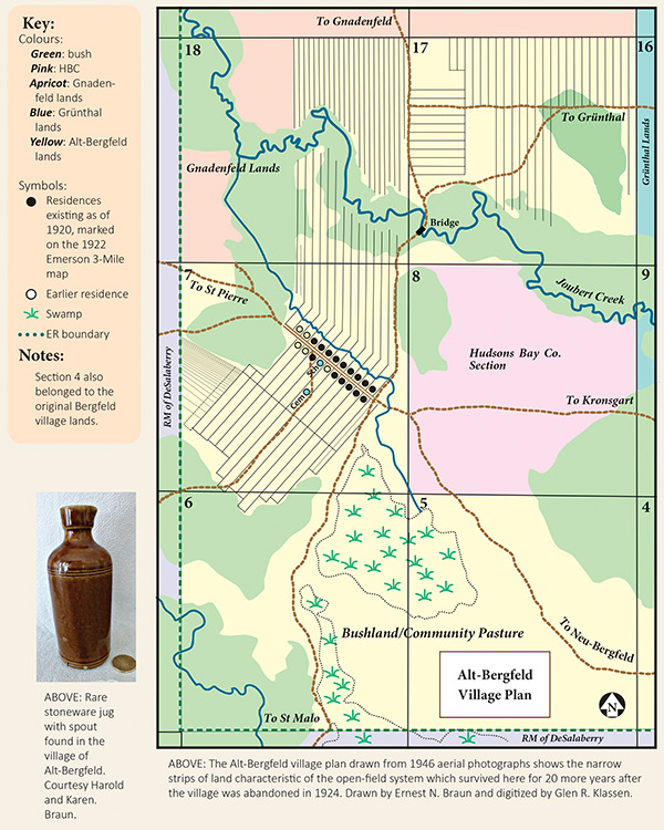
Part IV, “Township Profiles,” is by far the largest section140 pages. As the title indicates, a detailed profile is presented of each of the eight township, including maps of different aspects of the community. On these maps the authors locate natural features like streams, ridges, trails, and drainage canals, as well as community features like villages, schools, churches, cemeteries, cairns, and railways. Central for each township is a map of the villages, with a complete listing of the names of the people who took out initial patent to each quarter section. In the township that includes the town of Niverville (the only township with a railway town), the layout of the streets is included on a separate map. The discussion of each township is liberally augmented with large, colored photos of people, buildings, documents, scenery, and more. The maps and the narratives follow the story of East Reserve residents to the middle of the 20th century, including, for example, a map of school districts on the East Reserve in 1953. Excellent narratives interpret the history and the development of the various townships.
Part V includes a detailed discussion of the Scratching River settlement of Rosenort. In much the same way as Part IV does for the villages of the East Reserve, this section identifies original patent holders, and features maps locating the village, cairns, cemeteries, churches, and rivers.
Though the East Reserve consisted of eight townships temporarily reserved for Mennonite settlement, only 190 sections (or two thirds) of the 288 sections were ultimately available to the Mennonite newcomers. As was documented by the original surveyors, at best only 56% of that land was suitable for agriculture, with much of the rest identified as “generally unfit for settlement” (p. 54). Part VI has a fascinating discussion and accompanying maps of the out-migrations from the East Reserve. These out-migrations are the moves, between 1878 and 1883, of more than half of the East Reserve residents, most to a second block of land set aside for Mennonite settlement, the West Reserve. The story of out-migration also includes moves by small groups to Saskatchewan and Alberta, and the scattering of people to places in the United States. In addition, the writers detail that only a few years after settlement, some of the residents took up land immediately north of the Mennonite East Reserve, in effect enlarging the reserve, and establishing the centres of Greenland and Landmark as Mennonite communities.
The book concludes with an Appendix which shows, through maps, the shifting political boundaries of both provincial and federal ridings over the years. A selected bibliography, index, and glossary complete the book.
This beautifully illustrated, well written, carefully researched, and skillfully designed book makes a major contribution to the history of south eastern Manitoba, with particular focus on the Mennonite East Reserve. For the Mennonite East Reserve, it becomes the definitive study, and provides an apt model for similar studies of settlement communities throughout Manitoba.
This sample page from the Atlas shows the layout of the village of Alt-Bergfeld, established in 1876 and sold as a package in 1924 when most villagers emigrated to Paraguay in protest to the loss of promised rights to run their own schools in their own language and threats to Mennonite exemption from military service.
We thank Clara Bachmann for assistance in preparing the online version of this article.
We thank S. Goldsborough for assistance in preparing the online version of this article.
Page revised: 25 April 2021