by Brian Grover
Victoria, British Columbia
|
The following is a personal account by the author, who worked as a young engineer in the summer of 1964, leading a Manitoba Hydro survey crew along the Nelson River in northern Manitoba. Eds
The Nelson River flows about 644 km (400 miles) from Lake Winnipeg to Hudson Bay. Because there is a difference in elevation between the lake and the sea (about 217 metres or 713 feet) and a large volume of water flowing (averaging about 2,300 cubic metres per second or 84,000 cubic feet per second), the Nelson had long been identified as a future source of electric power. Manitoba Hydro had already developed the Kelsey dam and hydro plant in 1957 to provide power to an isolated mining operation (INCO) and its residential site in Thompson. Surveys and studies about future prospective power sites along the rest of the Nelson were well underway when I joined the utility.
Hydrometric surveys are intended to augment planning data by exploring the profile and cross sections of the river bottom. Such surveys also measure river flows, attempting to correlate flow volumes with water levels. Manitoba Hydro had been undertaking such surveys in previous years and was planning for the 1964 open water season when I learned about them.
In the summer of 1960, I had worked for Manitoba Hydro as an engineering student (third year at University of Manitoba). I was hired to work there again after graduating as a civil engineer in May 1961. That September I left Winnipeg and spent the following two years in the United Kingdom. I studied at the London School of Economics, earning a post-graduate diploma in Business Administration.
Returning to Manitoba Hydro in 1963, I began working in the power production part of the utility, dealing with reservoir operations for hydro plants on the Winnipeg and Saskatchewan rivers, while working concurrently on a master’s degree in engineering. In early 1964, I asked my employer for the opportunity to participate in that summer’s hydrometric survey of the Nelson River, partly due to my graduate studies, and partly because I wanted more experience. In April the head of Engineering (Jim Rettie) approved me to lead the crew, and my bosses in Production (Len Bateman, Jack Atchison, and Karl Renger) agreed to transfer me to a different part of the utility for the summer.
I particularly appreciated the chance to work in northern Manitoba with four Cree boatmen whom we hired at Cross Lake (now Pimicikamak) as key members of that year’s hydrometric survey crew. Because I recently discovered some photos from that era, I thought it might be interesting to reflect on that special summer, and to share some photos and ideas. While planning this essay I learned that families of the Cree members of our crew (all since deceased) were interested in photos and stories from that period. I met recently with a few members of the Pimicikamak Cree people and provided them with copies of an earlier version of this document. It was a great pleasure for me to meet these four individuals in Winnipeg in mid-2016: Jackson Osborne, William Osborne and his wife Joyce, and John Angus Monias, who are all related to former crew members Charles Osborne or Lazarus Monias.
The events from that summer’s experiences have been interpreted by a Brian Grover much different from the young engineer who worked on the Nelson River in 1964. I am now 77 years old, having retired 17 years ago after a very satisfying career, mostly in managing and developing water resources projects in developing countries. Through the lens of my lifetime experiences, I am now trying to interpret and explain what I recall from working 52 years ago on the Nelson River. I have never returned to that northern part of Manitoba. Accordingly I am trying to describe the 1964 survey without any personal experience about how the Nelson River region has changed since then. Some of the names of locations and potential power sites are different today from what they were in 1964.
Another change concerns the quality of the water in the Nelson River. When I was working there the water was clear, of high quality, so clean and fresh that we drank it directly from the river. We ate the fish we caught there without any second thoughts. In fact I was surprised by this reality, as I had known the waters of Lake Winnipeg to be turbid and murky in the populated southern portion of the lake, where the Red River enters the lake. I had been unaware of that lake’s ability to act as a huge, natural sedimentation basin, allowing flows into the Nelson River from the north end of the lake to be crystal clear.
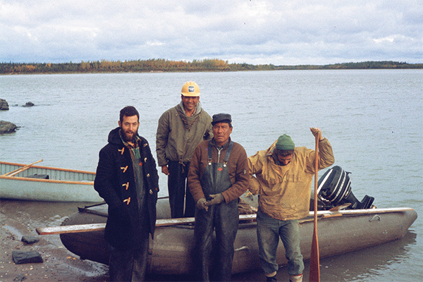
Depth sounding crew, left to right: Brian Grover (crew leader), Charlie Osborne and Lazarus Monias (boatmen), and Peter Quinn
(surveyor). The rubber boat, not used in previous summers, was powered by a 35 hp motor and worked very well, especially in fast water.
Source: Brian Grover
As an occasional summer tourist to family cottages around the southern basin of Lake Winnipeg, I am aware that water quality in this large lake (especially the smaller southern portion) has decreased considerably in recent decades. Erosion of the lake’s shorelines continues, perhaps aggravated by water levels now controlled at the north end of the lake by the Jenpeg dam. Apparently dams and flow management at Jenpeg (and possibly other dams) have also jeopardized the quality of water downstream in the Nelson River, with major impacts for northern residents.
In the previous year (1963) the hydrometric crew had been led by engineer Dave Pashniak. In 1964, he accompanied me to the field to introduce me to the practical realities of this job, and to help the current year’s survey team get started. Five of us departed Winnipeg by CNR train on 9 June: Dave, three engineering students and me. The next day we embarked at Wabowden and were flown by Beaver float plane of the Manitoba Government Air Service (MGAS) to our first camp at Red Rock Rapids. There, a separate Manitoba Hydro crew, led by John Veen and Jim Field, was exploring a potential dam site.
I flew with Jim Field and Dave Pashniak to Cross Lake on 11 June to recruit Cree boatmen for our summer’s work. The four people we sought, based on their extensive previous experience, were all available: Charles Osborne, Jack Miley McKay, and brothers John and Lazarus Monias. I learned from them subsequently that only John had attended school and was fluent in English, and that none of these four excellent workers ever had jobs under a roof. They had earned great reputations for being reliable, hard-working and wise. All four arrived at our campsite in their own boats the next morning and our summer’s work began.
Our surveyors were engineering students Peter Quinn, John Westdal and Al Millar, with me as overall crew leader and sonar operator. Our crew also included an experienced bush cook, Peter Wilchovy, who could make wonderful food on his portable, wood-burning tin stove.
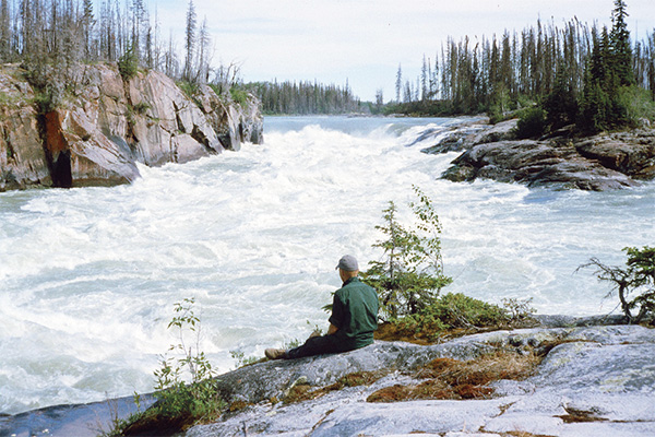
Surveyor Al Millar contemplates the dramatic east channel of Whitemud Falls. This section of the upper Nelson River required a
major portage around the falls.
Source: Brian Grover
There were four main tasks for our field crew of eight (four hydrometric surveyors and our four boatmen):
We would work long days (typically 10 to 12 hours, and occasionally more) from Monday to Saturday. When we worked near Cross Lake, our boatmen would return home for Sundays. Those of us southerners who stayed in camp would relax, go fishing (lots to catch), read, do laundry, write letters, or even go water-skiing.
Initially we worked on the upper Nelson River in the general vicinity of Cross Lake, starting at the Red Rock camp, doing hydrometric surveys to complement the land-based explorations by separate crews. During the summer we worked from seven different camp sites. Each time we relocated to a new campsite we had some routine chores: build a temporary dock for boats and float planes; clear the campsite of unwanted trees; set up our three big tents on freshly cut poles (sleeping quarters for the surveyors and for the boatmen, plus one large cook tent and dining room); dig a sewage pit and erect an outhouse; and dig another pit in the shade (into the permafrost), to serve as our refrigerator. The Cree boatmen were such experienced woodsmen and strong workers that we completed all these tasks at each new site within a few hours. Breaking camp for the next move, and readying all materials for transportation to the next camp, took even less time.
We used our camp radio to arrange for periodic deliveries of food and fuel by float plane. Several of the “bush pilots,” very skilled aviators, were former members of the RCAF, some of whom had flown during the Second World War.
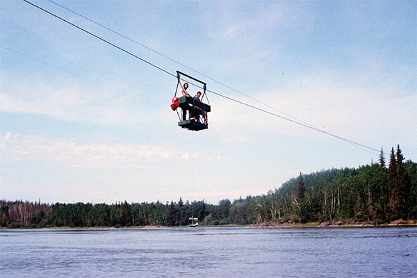
River flows were most reliably estimated by measuring the water velocity and depth at regular intervals, while pulling the cable car
across the river. Note the propeller meter hanging beneath the surveyors in the cable car.
Source: Brian Grover
Our two survey crews mainly concentrated on shoreline levelling and boat-based river cross-sections, typically about three sections per mile of river. We would gradually work upstream and downstream from our campsite. Experience showed that we could avoid excessively long travel times by boats on the river if we relocated the campsite approximately every two weeks. On relocation days, we would arrange for float planes to take most of our equipment to the new camp. Hence the terms “fly camps.” The Cree boatmen would then drive the boats to the new camp, portaging as needed around rapids and waterfalls.
After our arrival at the Red Rock camp on 11 June we relocated several times along the upper Nelson River: on 30 June to the Whitemud Channel; on 14 July to the Ominawin Channel; and on 31 July to Bladder Rapids, where we stayed longer than usual because we were also requested to survey the “thalweg” (deepest line along the channel).
Treaty time at Cross Lake in 1964 was from 21–23 August, during which time all of our Cree boatmen returned home. Some of us surveyors also visited Cross Lake then (discovering how difficult it was, without our experienced Cree boatmen, to navigate in the Nelson River). We were treated to wonderful hospitality by the Cross Lake residents during that festive time.
On 25 and 26 August we relocated to the lower Nelson River, near Kelsey, where we completed more detailed surveys of the river around the powerhouse. On 31 August and 1 September it took three loads on the big Otter float plane to deliver all our gear (including the two boats) to our next camp near Gillam Island. On 5 September we flew to our final camp at Gull Rapids.
Imagine our surprise on 3 September when we saw two German tourists in the lower Nelson who were awaiting a charter flight back south with Lamb Airways. They were on vacation from Frankfurt, and had paddled their canoe down the Nelson River as far as Gillam Island. They did all their own planning and portaging along this huge river with all its rapids and waterfalls. Brave and energetic people, for sure!
The weather in northern Manitoba deteriorated, giving us our first taste of winter: sleet and snow on 9 September. We finished our season’s work soon thereafter, with John Monias and Jack Miley McKay flying back to Cross Lake on 13 September, while students John and Al headed to Kelsey, en route to Thompson. Charlie, Lazarus, Pete and I flew back to Kelsey for some further sonar work there on 14 September. The next day we went our respective ways back to our homes; I flew to Thompson and onwards to Winnipeg with Transair.
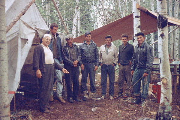
Life in temporary fly camps was seldom dull and often fun. Here cook Pete Wilchovy (far left in the cook tent) admires the crew’s
pet goose. Others (left to right) are John Westdal, John Monias, Jack Miley McKay, Lazarus Monias, Peter Quinn, and Charlie Osborne.
Source: Brian Grover
I have never seen any of the men with whom I enjoyed working on the Nelson River since we parted in mid-September of 1964. All four of our boatmen have reportedly died, and probably our cook Pete, too. Our nine-man crew had spent just over three months together, working together very well in challenging circumstances, relying on one another for friendship as well as for our survival—especially us southerners, who could not possibly have completed the work without our excellent Cree boatmen. I continue to hold them in my memory with great respect. Charlie, Miley, John and Lazarus taught me much, especially about working hard and coping well in the tough environment of northern Manitoba.
I have since realized that Manitoba Hydro has been well served by many northern residents over many decades. The Cree Nation (and others) has been helping foreigners from Europe and elsewhere in central Canada for more than three centuries, ever since the Hudson’s Bay Company was established in 1670. I feel very privileged to have enjoyed working in northern Manitoba with these reliable, friendly Cree workmen on our hydrometric survey crew in that summer of 1964. Now I realize that I was participating in a process of working with northern Manitoba residents that had begun many generations before, and still continues.
What I also recognize now, but did not fully appreciate in 1964, is that the standard of living in this remote, northern part of the province is significantly lower than that enjoyed in the urban and rural areas of southern Manitoba. By any of the standard measurements of quality of life (including shelter, education, income, diet, drinking water supply, sanitation, health services and life expectancy), northern Manitobans (especially on First Nations reserves) live in much worse conditions than most other Canadians. In fact the quality of life in northern Manitoba, in 1964 and apparently nowadays, is more typical of the many developing countries where I worked in my engineering and management career. Persistent Third-World conditions are quite real in many regions of our affluent, First-World country.
We Canadians face huge challenges in creating a just society where the First Nations, those people who were present long before immigrants arrived from many other countries, should be able to enjoy the high standards of living which most other Canadians have already achieved in our recent history in this land. I scarcely understood this fundamental reality when I worked along the Nelson River in 1964.
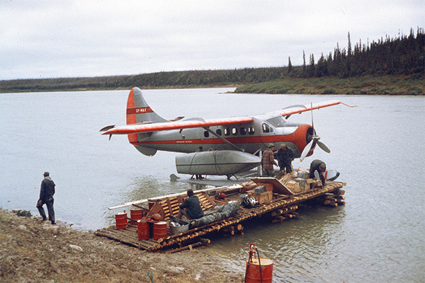
The Otter float plane was used for our largest loads, such as this one at the end of August. Note the canoe strapped to the plane’s
float, also the fuel drum on shore. Very experienced pilots were essential in these conditions. Three separate flights were needed for this large quantity of materials as we moved to the lower Nelson River.
Source: Brian Grover
I might not even appreciate this reality now, had I not had the opportunity 52 years later to meet with some now-adult children of my previous crew of Cross Lake boatmen. Doubtless I have also been influenced by our settler society’s gradual awakening to previous colonial and racial injustices, as recently documented by the Truth and Reconciliation Commission. I now recognize that our entire society needs to continue learning and responding to our previous mistakes, even if they may have been innocent errors at the time.
Another topic on which I am poorly informed, but which seems very important to residents of northern Manitoba, concerns the environmental consequences of Manitoba Hydro’s massive power developments along the Nelson River. Only the isolated Kelsey plant existed when I worked in this region in 1964. Since then Lake Winnipeg has been turned into a giant reservoir by the Jenpeg dam, to enable winter flows down the Nelson River to better match higher power demands in the winter. According to Cross Lake residents, these fundamental changes have resulted in much erosion of river banks, dirtier water, and higher winter flows, which disrupt river ice cover (and hence winter transportation). From afar it looks to me like the relatively few residents of northern Manitoba are bearing huge environmental consequences.
Will conclusions from my personal reflection possibly be shared by others? Will injustices affecting First Nations people by newcomers from other lands ever be remedied? Time will tell. Hopefully historians in future generations will review how such issues are being addressed (or not) during our current era with factual information, interest and empathy.
This article is a condensed version of my e-book “Summer of ’64 on the Nelson River” which includes maps, more photos, additional information, and a deeper reflection. This e-book can be obtained free of charge from the MHS website (www.mhs.mb.ca/docs/memoirs). Sheila Grover suggested the concept and worked on all drafts. However, any flaws which remain are my own responsibility.
We thank Clara Bachmann for assistance in preparing the online version of this article.
We thank S. Goldsborough for assistance in preparing the online version of this article.
Page revised: 19 November 2020