by John Lehr, Brian McGregor, and Weldon Hiebert
Department of Geography, University of Winnipeg
|
Hutterites are German-speaking Anabaptists who believe in the community of goods. They follow the teachings of Jacob Hutter who was martyred for his faith in 1536. Believing that Christianity should be practised in daily life they live together in colonies and hold all things in common. In their dress they retain the peasant costume of central Europe in the sixteenth century but in their agricultural and other economic operations they employ cutting-edge technology. Their withdrawal from the world, retention of the German language, and adherence to pacifist beliefs, has brought them into conflict with the secular societies within which they have lived for the past hundreds of years.
Originally from the Tyrol area, the Hutterites migrated across Europe seeking freedom of conscience and refuge from persecution. After a hundred years in Ukraine Hutterites once again felt growing pressure to integrate with surrounding society and to compromise their beliefs. From 1874 to 1877 many left for America where they settled in South Dakota establishing colonies in the Jamestown area. For thirty years they were able to practise their beliefs and enjoy colony life there. In 1917, when the United States entered the war against Germany, the Hutterites were immediately targeted for their refusal to bear arms and their use of the German language. Hutterite youth were forcibly conscripted. They refused to abandon their principles and were treated brutally, some died in military prisons. [1] In 1919 Hutterite leaders decided to move their colonies to Canada, believing that they would receive better treatment under British law. Their American lands were leased out or sold and land was purchased in Cartier Municipality, Manitoba, and in various places in southern Alberta. Those who belonged to the Schmiedeleut branch all settled in Manitoba, those from the Dariusleut and Lehrerleut branches went to Alberta. All of the more than 400 Colonies in Canada grew from the first 18 colonies that arrived in 1919. [2]
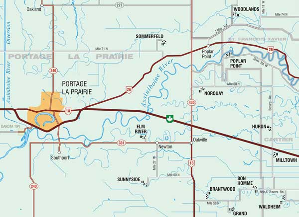
In the summer of 1999, Johnny Hofer of James Valley Hutterite Colony near Elie asked the Department of Geography, at the University of Winnipeg, if it could assist the Hutterian Brethren to produce an atlas of Hutterite colonies in North America. At the time no up-to-date map of Hutterite colonies was available, and those maps that did exist showed colony locations only in general terms. This caused problems for Hutterites travelling to unfamiliar colonies as the postal address did not always reflect the colony’s real location. A post office box address could be located in a town miles from the colony, and in one instance, across a provincial boundary (Map 1).
Map 1. A sample page from the forthcoming Hutterite Atlas.
The primary contact person with the Hutterites was John Lehr; Weldon Hiebert was responsible for the atlas design and cartography, and Brian McGregor undertook the data management and was responsible for the Geographic Information Systems (GIS) component of the project. In gathering data, this team worked in close cooperation with Johnny Hofer, Patrick Murphy and John Hofer of James Valley, and Tony Waldner from Forest River Colony in North Dakota.
The first step was to obtain the latitude and longitude of every Hutterite colony in North America, its name, postal address, and the leut [or branch of the Hutterite church] to which it belonged. While gathering this data the colony’s date of establishment and the name of its mother colony were also sought. Information was drawn from the 2005 Hutterite [Telephone] Directory, which lists all colonies and provides their postal addresses and the leut to which they belong. Geographical coordinates (latitude and longitude) were obtained for all American colonies from topographic maps which, in the USA, name all Hutterite colonies. Unfortunately, although Canadian colonies are marked on topographic maps they are not named; this complicated the process of identifying locations. Other sources were used to identify colonies on the maps. In Manitoba, for example, MTS Manitoba White and Yellow Pages (phone book) listed Hutterite colonies by section, township and range. The same information was available for Alberta colonies using a list of colonies acquired by an Alberta feed company. Once all of the more than 480 colonies were identified, their geographical coordinates determined, and the date of establishment ascertained, a data matrix was constructed.
Computer aided map production has greatly simplified the task of plotting geographical and historical data. In the past, constructing a map to show the distribution of any phenomena was a laborious and time-consuming task. This was especially true when attempting to show how a geographical pattern had evolved over time, as creating a series of maps required the same base map to be redrafted over and over again. For example, before the advent of computer technology, if one wished to construct a series of maps that would illustrate how the Hutterite colonies in North America had diffused from their point of origin in South Dakota, a series of difficult decisions would have to be made, and adhered to. Since the location of each colony would be plotted by hand it would be impractical to plot the data on an annual basis, since to create a time series with such a narrow interval would entail producing hundreds of maps. As only a limited number of maps could practically be produced data would only be plotted for selected years. The years selected would not necessarily be those that best reflected critical developments in the evolution of the emerging pattern.
Application of computer technology has changed this situation. Although GIS programs have not changed the way in which geographers analyse data they have automated the production process to such an extent that researchers can now use spatial data far more effectively. Now, once the researcher’s data has been entered into the computer, it can be easily manipulated, plotted, and printed in map form. Additional information such as the location of roads, railways, political boundaries and vegetation patterns can be entered by the researcher or obtained in digital form from a variety of sources. At the touch of a button, information can be sorted, data fields cross referenced, and maps produced that enable quick visual comparisons to be made of the relationship between say, vegetation and settlement in different years.
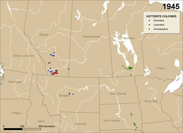
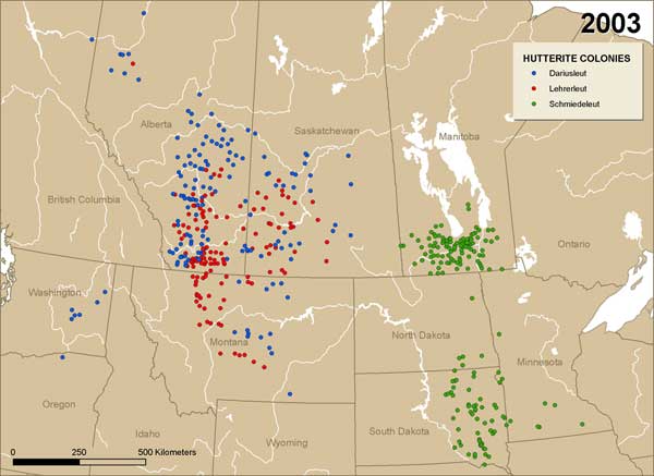
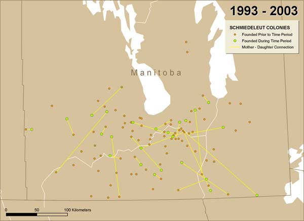
In the course of gathering data for the production of the atlas a great deal of historical data was collected that permitted the production of maps that showed the location of every Hutterite colony in North America at any given time (Maps 2 and 3). Using GIS has also made it easy to change the time interval between mapped data, to plot colony locations according to leut, to indicate whether a colony was extant or defunct, and even to indicate relationships between mother and daughter colonies (Map 4).
Map 2. Hutterite colonies in North America by leut, 1945.
Map 3. Hutterite colonies in North America by leut, 2003.
Map 4. Schmiedeleut colony diffusion in Manitoba, 1993-2003.
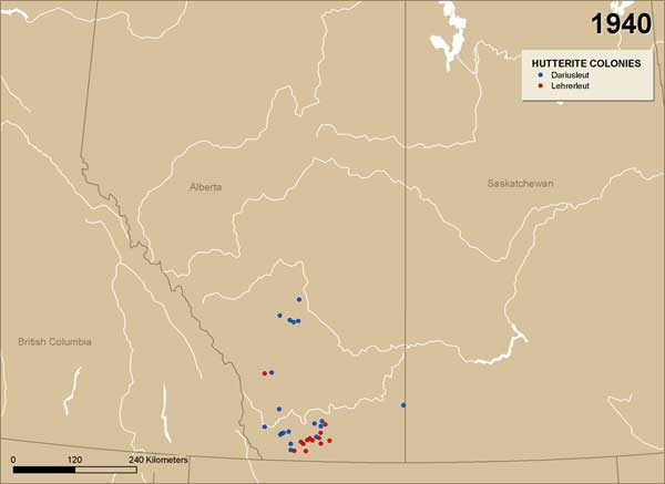
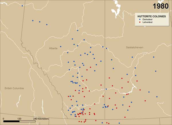
The reasons for the present pattern of Hutterite colonies in North America are many and complex. The initial migration to Canada was a response to persecution but colony expansion was a response to various discriminatory laws, such as the Alberta Communal Property Act, that intended to disperse Hutterites and prevent them from being a significant presence in any one area. In Manitoba similar restrictions were placed on the Hutterites under a socalled “gentlemen’s agreement,” that lasted until 1972 when the provincial government declared it to be unenforceable. Alberta’s Communal Property act was repealed in 1973. A comparison of Maps 5 and 6 reveals the effects of these restrictions on the locations of new colonies. Dariusleut and Lehrerleut colonies that were unable to obtain land near existing colonies moved into the Peace River District and across the provincial boundary into Saskatchewan.
Map 5. Dariusleut and Leherleut colonies in Canada, 1940.
Map 6. Dariusleut and Leherleut colonies in Canada, 1980.
Producing a series of maps showing the change in a pattern or distribution over time was obviously possible in the days of manual cartography. However, the amount of time needed to create each map usually meant showing the change with a very low temporal resolution, that is, with a small number of maps showing conditions at widely spaced points in time. The computer mapping capabilities of Geographic Information Systems allow the temporal resolution to be as detail as the data will allow. For example, if we had an official day, rather than year, for the establishment of each new Hutterite colony and we thought it would help us understand colony dispersion, we could have created an animated series of maps showing change on a daily basis.
The ability of GIS to rapidly create time series maps makes it a useful tool in visualizing change in distributions over time. This is but one of many interesting applications of GIS for historical geographers and historians exploring historic spatial data. For example, GIS offers the possibility of quickly selecting events based on their proximity to other events or objects.
Over the years foresters, wildlife managers, urban planners, geologists, archaeologists, farmers, business analysts and many other disciplines have adopted GIS as a tool. Every few years another group “discovers” GIS. We hope that this brief paper has demonstrated some of the potential of GIS as an aid in historical research.
The authors wish to thank the University of Winnipeg and the Chair in German Canadian Studies at the University of Winnipeg, for their support of this project.
1. Hofer, John, The History of the Hutterites. Elie: Manitoba: James Valley Book Centre, 1982, pp. 62-65.
2. Hutterites belong to one of three branches or Leute. The group that were led to North America by a teacher (lehrer) are known as the Lehrerleut (literally, the teacher’s group). Others led by Darius are the Dariusleut (or Darius’ group) and those who followed a blacksmith are the Schmiedeleut (Smith’s group). Although they are all Hutterites, there are subtle differences between the three groups.
Page revised: 26 June 2012