by Patrick Carroll
Parks Canada, Winnipeg
Number 41, Spring / Summer 2001
This article was published originally in Manitoba History by the Manitoba Historical Society on the above date. We make this online version available as a free, public service. As an historical document, the article may contain language and views that are no longer in common use and may be culturally sensitive in nature.
Please direct all inquiries to webmaster@mhs.mb.ca.
Help us keep
history alive!The Oberholtzer Foundation, Toward Magnetic North: The Oberholtzer-Magee 1912 Canoe Journey to Hudson Bay, (Jean Replinger, editor and project coordinator), Marshall, Minnesota: The Oberholtzer Foundation, 2000, 128 pp, illus., ISBN 0-9703138-0-2, $50 (US).
All day the sun shone and at evening went down in a rich sunset. A clear mass of colour toning from wine at the horizon to old gold above was broken only at the top by a great hand-like cloud of gray-blue extending with outstretched fingers from the north. Gradually, all the underside of the cloud brightened into scarlet puffs and the water all round was shimmering in old gold. None of the colours were brilliant, probably because of a slight haze. A seal’s head came up in the midst of the gilded water. The eastern sky was a mass of foggy clouds, through which the moon showed at first vapoury and without light and then in a pleated reflection across the billowing water that looked like a Japanese lantern. Not till eleven o’clock after we went ashore, did it come out bright from the clouds, and even then with two halos — an inner brownish one and an outer circle of spectrum.
Ernest Oberholtzer, September 29, 1912
On June 26, 1912, Ernest C. Oberholtzer and Billy Magee set out, unguided, from the Pas, Manitoba, for a canoe trip which would take them north to Brochet and Neultin Lake, east along the Thiewiaza River to Hudson Bay, south by way of Churchill and York Factory, then inland up the Hayes River to finally arrive, after five months of travelling, at Gimli, Manitoba, on November 5, 1912.
Oberholtzer was twenty-eight years old in 1912. Billy Magee was a fifty-one year old Ojibway from Ontario. The two men had developed a friendship having spent several summers tripping in the Quetico-Superior region. Neither man had ever canoed beyond the lakes and rivers of the Rainy Lake watershed and their only knowledge of the north was Oberholtzer’s enthusiastic reading of the available literature. Together they managed to traverse approximately 2000 miles of wilderness, a large portion of which was unmapped and largely unknown except to the aboriginal inhabitants. Contributing editor Robert Cockburn [1] states that:
In 1912, representations of Nu-thel-tin-tu-eh, or Sleeping Island Lake, that appeared on maps were based solely on native reports, conjecture, and the experiences of the great English explorer Samuel Hearne. Hearne had crossed “Island Lake” in the winter of 1770-71, but his depiction of it, in both his 1772 map and his published 1795 map, owed next to nothing to actual observation or surveying. [J. B.] Tyrrell, who had journeyed far to the west of Neultin Lake, showed it on his 1896 map as a crude shape in dotted lines. (10)
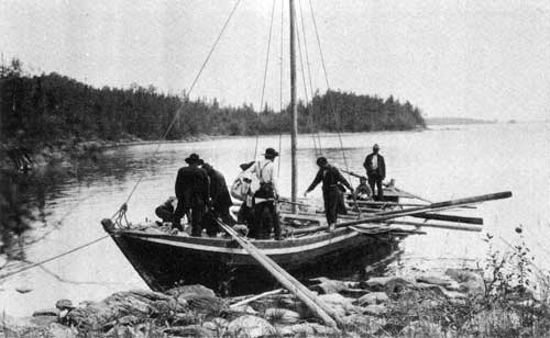
York boat with crew and passengers, 1912.
Source: The Oberholtzer Foundation
When he heard of what the two men had accomplished, the explorer J. B. Tyrrell was prompted to comment on the audacity of their achievement. He wrote to Oberholtzer in 1912: It was a hazardous undertaking for you to go through that northern country with one Indian who knew nothing of it...and I heartily congratulate you on having made a good adventurous journey which will add materially to our knowledge of that portion of Northern Canada. [2]
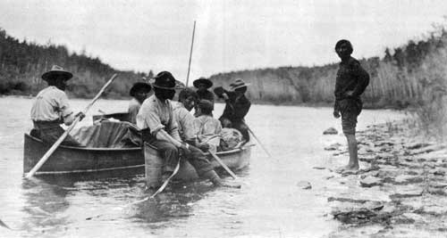
Two canoes of the Revillon Freres Trading Company, 1912.
Source: The Oberholtzer Foundation
Although at the time, it seemed Oberholtzer and Magee would be secured a place in northern lore, Oberholtzer failed to publish his journal or any of his many photographs during his lifetime. Following his return to Minnesota in 1912, Oberholtzer took up residence in the Rainy Lake region where he quickly became the major proponent in the fight to create a wilderness preserve in the Quetico-Superior boundary waters. For the rest of his life Oberholtzer was dedicated to defining a wilderness ethic and seeing it applied to the Rainy Lake watershed. The struggle would continue until his death in 1977, at the age of ninety-three, when it was said that “when the long, long history of the now famous Quetico-Superior region is written, the name Ernest Oberholtzer will bulk large near the top of the list.” [3]
Oberholtzer’s story has remained the stuff of legend but has never achieved its proper place in the annals of northern achievement. In the late 1940s, Sigurd Olson became acquainted with Oberholtzer when Olson joined the Quetico Superior Council as the resident ecologist. In 1947, Olson resigned his position as dean of Ely Junior College to start a new career as a writer and wilderness preservationist. Undoubtedly, Olson helped to spread the story of Oberholtzer’s northern trip. P. G. Downes mentions Oberholtzer in his chapter on Neultin Lake in his classic Sleeping Island. [4] Downes states that “no record of this trip, an extremely laudable one, was ever published, but Oberholtzer was dimly remembered by a few of the really old residents of the country”. Calvin Rutstrum, in his 1964 guide to canoe technique, North American Canoe Country, [5] included the ‘Oberholtzer-Magie [sic] Journey’ in his chapter entitled “Some Significant Canoe Voyages.” Other than these brief references to Oberholtzer, and more recent research by Robert Cockburn, [6] the story of the Oberholtzer-Magee trip, and the wealth of associated documentation has remained virtually unknown as a source of information for northern researchers and enthusiasts alike. Nearly a century later, Toward Magnetic North: The Oberholtzer-Magee 1912 Canoe Journey to Hudson Bay, may be the first step in generating a larger appreciation of the documentation surrounding Oberholtzer’s journey through the barren lands.
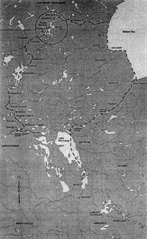
Canoe route of Ernest Oberholtzer and Billy Magee through northern Manitoba and the North West Territories. Their trip began in June of 1912 at the Pas and ended in early November of that year in Gimli.
Source: The Oberholtzer Foundation
Toward Magnetic North includes almost half of the 150 photographs taken during the trip, accompanied by excerpts from the unpublished journal. [7] Visually striking, and often remarkably candid, the photographs reflect the various aesthetic and historic interests which invigorated Oberholtzer’s imagination. None of the photographs are staged; they are snapshots, literally, of life at the tree line just prior to the incursion of the modern world. The images are of a surprisingly high quality, when one considers the time period and the conditions under which they were taken and developed. A short essay on Oberholtzer’s photographic technique states that he occasionally washed his processed film by dragging it through the water behind the canoe. His camera, a 3A Graflex, was one of the first through-the-lens reflex cameras. To take a picture, one had to set
the Graflex’s focal-plane shutter [by] giving a knob a few turns; that action also reset the mirror, making the image about to be created visible on the ground-glass viewer. When unfolded and ready for action, the camera measured about six inches wide, ten inches deep, and a foot high, and it weighed at least six pounds. (14)
The camera would then have to be held steady to allow for the wider aperture settings and slower shutter speeds necessitated by the slower film speeds available at the time. Still, according to Ray Anderson, photo archivist for the Oberholtzer Foundation, “Ober produced very few blurry images.” [8]
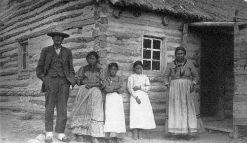
Dene family in front of their log home at Brochet, Manitoba, July, 1912.
There are a number of short essays accompanying the photographs including a discussion of the 1912 trip, and another on Oberholtzer’s life following the trip including his admission into the Explorer’s Club and his work with the QueticoSuperior Council. There is also an essay discussing the relationship between Oberholtzer and Magee. Oberholtzer interviewed members of Magee’s family in an attempt to document Magee’s experience of the trip. The tapes have apparently been translated, but, unfortunately, the essay included in the book provides little information on Magee’s perspective. The final essay is a memoir by a close friend of Oberholtzer’s who returned with him, in 1963 when Oberholtzer was nearly 80, to Neultin Lake to retrieve a note he had left in a cache there in 1912.
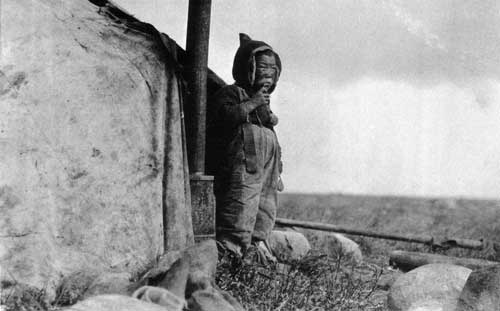
Oh-rut-yuk, a ten-year old Inuit child photographed near the mouth of the Thlewiaza Rivr, September, 1912.
Source: The Oberholtzer Foundation
Toward Magnetic North contains nearly seventy images of the people and their way of life in the southern barren lands just prior to the region entering the twentieth century. The images are engaging and uncannily honest. Perhaps this is because Oberholtzer and Magee were not undertaking official work, and were ultimately dependent upon the good-will of the northern residents they encountered. Whatever the reason, the photographs are unique and should be of interest to both northern researchers and enthusiasts.
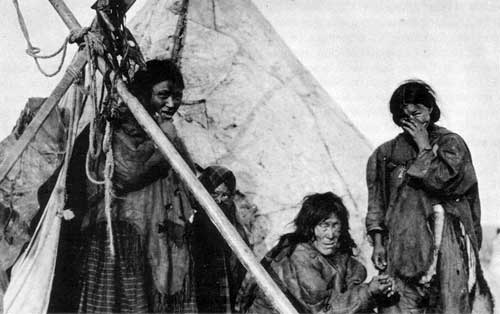
Inuit women and girls photographed at an encampment on the west coast of Hudson Bay, September, 1912.
Source: The Oberholtzer Foundation
Much care was obviously taken in the reproduction and in the initial selection of the images to be reproduced in the book. Toward Magnetic North, along with the journal once it is published, will make a wonderful addition to the existing body of northern literature, documenting as it does, an extremely personal, often candid, and unromanticized experience of a world now lost to us.
1. Robert Cockburn, Ober As Explorer, in Toward Magnetic North: The Oberholtzer-Magee 1912 Canoe Journey to Hudson Bay (Oberholtzer Foundation, Marshall, Minnesota, 2000).
2. As quoted in Lobsticks and Stone Cairns: Human Landmarks in the Arctic, edited by Richard C. Davis, (Calgary: University of Calgary Press, no date), p. 130.
3. R. Newell Searle, Saving Quetico-Superior: A Land Set Apart (Minnesota Historical Society Press,1977). A biography entitled Legend: The Life Journey of Wilderness Preservationist Ernest Carl Oberholtzer, by Joseph Paddock is forthcoming from the Minnesota Historical Society press.
4. P. G. Downes, Sleeping Island: The Story of One Man’s Travels in the Great Barren Lands of the Canadian North. Forward and notes by R. H. Cockburn (Western Producer Prairie Books, 1988).
5. Calvin Rutstrum, North American Canoe Country: The Classic Guide to Canoe Technique (University of Minnesota Press, 2000).
6. Robert Cockburn, “Voyage To Neulthin”. The Beaver, no. 1, January-February 1986, p. 66, and After Images of Rupert’s Land From the Journals of Ernest Oberholtzer (1912) and P. G. Downes (1939) in Rupert’s Land, A Cultural Tapestry. Edited by Richard C. Davis, (Waterloo, Canada: Wilfred Laurier University Press), 1989.
7. An illustrated edition of Oberholtzer’s 1912 journal, edited by Robert Cockburn, is forthcoming from the Minnesota Historical Society.
8. Ray Anderson, Ober As Photographer, in Toward Magentic North: The Oberholtzer-Magee 1912 Canoe Journey to Hudson Bay (Marshall, Minnesota: Oberholtzer Foundation), 2000.
Toward Magnetic North: The Obeholtzer-Magee 1912 Canoe Journey to Hudson Bay can be ordered from the Oberholtzer Foundation, 300 North Hill, Marshall, Minnesota, 56258, U.S.A. Manitoba History wishes to thank the Oberholtzer Foundation for permission to use its photographs for this issue and asks readers who might have information regarding the identity of the Native woman on the cover of this issue to please contact the Foundation.
Page revised: 17 October 2011