by Thora Cartlidge, Minneapolis
and Graham A. MacDonald, Winnipeg
|
What is it about Winnipeg and Minneapolis/St. Paul that invites comparison with respect to heritage site developments along their riverbanks? Functionally, the early histories of the two areas are similar. Both centres developed in the late nineteenth century as undisputed gateways to the great plains. During the fur trade era the two centres also became progressively linked by trail, water and rail. By the 1860s St. Paul had gradually displaced York Factory as source of trade goods for the interior posts of the Hudson’s Bay Company.
As in the heart of Winnipeg, Minneapolis/St. Paul is dominated by a major river landscape. Whereas in Winnipeg it is the lower reaches of a large watershed defined by the Red-Assiniboine drainage which come together at the historic “Forks”, in Minneapolis it is the upper stretch of the Mississippi River which winds through the city. The concentration of historic resources along the Mississippi at the Falls of St. Anthony has been recognized as a special opportunity for government, business and civic groups to preserve and interpret the city’s history. In much the same way, government policy has been attempting to turn Winnipeg’s Forks into a special place. Interestingly, the two cities have been pursuing their individual programs for approximately the same length of time.
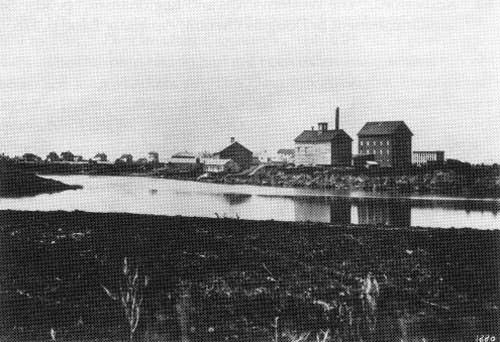
The Forks of the Red and Assiniboine Rivers, 1880.
Source: National Archives of Canada, PA-9906
Conceptual planning for riverbank development in Minneapolis has been underway for over a century but received strong direction in the 1970s. A visionary plan for the central riverfront was prepared in 1977 which emphasized the establishment of a trail corridor and interpretive strategy. Ten years later the research and lobbying efforts of the City of Minneapolis and the Minnesota Historical Society helped convince the State Legislature to establish the St. Anthony Falls Heritage Board in 1988. The board’s mandate is to coordinate the planning and implementation of the interpretive system, and administer a grants-in-aid program for projects identified in the interpretive plan.
These initiatives are somewhat parallel to the late 1970s signing in Manitoba of the Canada-Manitoba Agreement for Conservation and Recreation on the Red River. This provided for tri-level cooperation between the City of Winnipeg, the Province of Manitoba and the Canadian Government for the preparation of a concept and implementation plan for the Lower Red River. This included the Forks of the Red and Assiniboine River, the historic but industrialized heart of the City. An important principle of this agreement was the provision for the transfer of lands at the Forks owned by the Canadian National Railway (a federal crown corporation) to the Province of Manitoba. This initiative, when completed, was followed by the establishment of the Forks Renewal Corporation, which oversaw and implemented plans for a large portion of this new area of open public land.
In Minneapolis, the St. Anthony Falls Interpretive Plan is a comprehensive plan for interpretive development of the historic resources in the area of St. Anthony’s Falls. It not only reflects previously completed plans, but sets out a strategy for implementation through a series of public/private partnerships. Unlike the Forks Renewal Corporation in Winnipeg, the St. Anthony Falls Heritage Board functions more as a facilitator than as a land development body.
At the heart of the proposed interpretive system is the St. Anthony Falls Heritage Trail. When completed the trail will direct visitors to the historic neighborhoods, industrial sites, archaeological remains and geological features which give identity to this part of the Mississippi River. An orientation centre, exhibits and a public history program will help visitors to make sense of the heritage resources that are encountered along the trail. The trail will be built as a collaborative project by public and private partners.
While public agencies and private corporations may seem to be unlikely partners in the interpretation of history, in Minneapolis it is anticipated that support for the St. Anthony Falls Heritage Trail will derive from all levels of government, citizen’s groups, and private corporations whose history is still visible along the banks of the Mississippi.
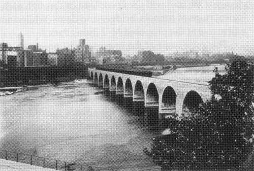
The Falls of St. Anthony, Mississippi River, circa 1890.
Source: Minnesota Historical Society
The Falls of St. Anthony form the only cataract along the entire length of the Mississippi River. Located above the confluence of the Minnesota and Mississippi Rivers, the falls are defined by a rapidly eroding layer of limestone and sandstone, and owe their origin to the forces of glacial retreat some 10,000 years ago. When the Franciscan priest Louis Hennepin recorded his observation of the falls in 1680, he named them for the patron saint of exploration, St. Anthony of Padua.
After the establishment of the military post, Fort Snelling, at the confluence of the Mississippi and Minnesota Rivers in 1819, other industry followed. A rise in demand for saw logs and a flour-milling water power supply, led to the construction of the dams and sawmills in the 1820s. This served to accelerate the rate of erosion at the Falls as the impact of log drives and new construction caused the limestone to joint severely and break off in blocks. The falls would have disappeared altogether into a series of rapids had they not been engineered with a series of protective aprons to stop further erosion.
The rise of Minneapolis to predominance in the flour milling industry was due partly to the availability of the waterpower, and partly to the ingenious application of waterpower technology that drew water off the river and through a complex canal and tunnel system into turbines that powered mills overhead. The Pillsbury and Washburn ‘A’ Mills which stand today as National Register Historic Sites, were considered the apex of milling technology in the 1880s.
The recreational possibilities for the river were recognized early. In 1883, the landscape architect H. W. S. Cleveland recommended an extended system of boulevards including ones along the river, rather than a system of detached parks. These ideas were reinforced in the 1917 Plan of Minneapolis prepared by architect Edwin H. Bennett. His plan called for a riverside park lining both sides of the river with construction of a series of low and high level drives and the islands below the falls opened for public and commercial uses.
By 1930 the City of Buffalo, New York had taken the lead in the flour milling industry. In Minneapolis, many west-side mills were burned or razed over the next few decades when developers’ attention was focussed strongly on the hydroelectric potential of the Falls, on harbor improvements, and on the construction of a lock and dam system. The most significant heritage ideas advanced in these years involved park proposals made in the 1940s for “the Great River Road”, a concept which was to stretch the entire length of the Mississippi River.
It was not until the 1960s and ‘70s that the recreational and historic potential of the area was assessed in any detail. Following the listing of the St. Anthony Falls Historic District on the National Register in 1971, numerous studies were undertaken associated with the transfer of riverfront property from private to public ownership. In 1978, the Minneapolis Park Board received funds to purchase lands for a proposed Central Riverfront Regional Park. That same year In Winnipeg, the Canada-Manitoba Agreement for Recreation and Conservation Concept Plan for the Red River was tabled, sanctioning a range of projects and a long-term land assembly programme. Unlike Minneapolis, much of the requirement in Winnipeg was to finance and negotiate a major land transfer from the Canadian National Railway which had occupied prime heritage lands at the Forks since early in the 20th century. Also unlike Minneapolis, once the desired lands were obtained, there was no firm detailed interpretive plan in place to provide criteria for privately-sponsored development. Only the Federally-owned park at the Forks was developed with the benefit of a detailed management plan. The Forks Renewal Corporation has been mandated to act as a land developer on a project by project basis rather than as an implementor of a formalized heritage plan. This may partly be explained by the relative lack of extant heritage resources along the downtown stretches of the Red River, particularly at the Forks.
At the Falls of St. Anthony, the adaptive use of many historic commercial buildings within the mill districts, accompanied by the opening of new recreational space along the riverbanks and on Hennepin and Nicollet Islands, has attracted new visitors, residents, and workers to the area. A number of intensive studies of the archaeological and architectural resources have identified a wide range of interpretive themes, and these ideas have been synthesized in the 1990 Interpretive plan. The City’s expectation of an interpretive system is to “integrate all the diversity inherent in an intensely urbanizing setting”, develop civic pride and regional identification, plus accommodate and complement the recreational goals and economic development set for the historic area. Industry on the other hand, has remained a constant at the riverfront through all the changes in land use and perceptions of the area.
In contrast, Winnipeg turned its back on the rivers in the late 19th century when transportation development started to redefine the essential economic character of the city. While some industry settled on the riverbanks, it was railway routes which gave greater definition to these areas. The major achievement in recent conservation has been the stimulation of adaptive re-use of the old Warehouse District through legislative incentive and protection. Revitalization aimed at reclaiming areas of the riverbanks has also been sponsored under the Canada-Manitoba A.R.C. program, and the Winnipeg Core Area Initiative.
The challenge to the St. Anthony Falls Heritage Board has been to design an interpretive system that organizes the story in ways that enable visitors to make connections between what they see today and what was there before. Although the Heritage Trail will cover a two-mile area, it will first direct the visitor’s attention to the concentration of historic resources in the vicinity of the Falls by means of theme trails dedicated to topics such as geology or urban change. One trail will take people to or through archaeological ruins of tunnels, bridges and dams while another will arrive at the proposed Mill Ruins Park.
This raises one of the important differences between the Minneapolis situation and that of Winnipeg: the relative number of tangible heritage resources extant in the river areas. At the main focus of activity in Winnipeg, the Forks, the post-1870 resources are few. Industrial modification over time has limited the finds made to date by archaeologists with respect to the fur trade and Native history. The vestiges of old industrial sites are also quite limited. In Minneapolis on the other hand there is an abundance of features of genuine interest, particularly from the post-1880 period.
On-going developments in Minnesota and Manitoba reflect a wide-ranging series of public/private partner-ship experiments which have come into play in recent years at places such as the historic mill town in Lowell, Massachusetts, the Cape Cod National Seashore and the Illinois and Michigan Canal. Unlike the American experiments, the Winnipeg Forks Development remains driven by development capital unguided by strong heritage project guidelines in the form of an interpretive plan.
Page revised: 11 April 2010