by Francis M. Carroll
University of Manitoba
Manitoba History, Number 4, 1982
|
This is an interesting and important history. William E. Lass. who has written several volumes on topics related to Minnesota including the bicentennial history, states that this book had its origins in the need to explain the peculiarities of the boundary to his undergraduate classes in Minnesota history. The story of the Canadian-American boundary, even from Lake Superior to the Red River, including the Northwest Angle, is complicated and covers a long span of time. Lass has attempted to pull the whole narrative together, and happily he has succeeded. It is fair to say that the history of this portion of the boundary has been very much overshadowed by writings focused on the North-eastern boundary and on the Oregon question. The Great Lakes border, the Lake Superior to Lake of the Woods boundary and the 49th parallel line have generally been described as something of a compromise, if in fact not an after thought. Such glib statements do not do justice to the complex and prolonged disputes that arose from these sections of frontier.
Lass begins with the controversial peace treaty ending the Revolutionary War. It was, of course, from this instrument and its deficiencies that much of the subsequent difficulties emerged. As a result of the inadequacies of the existing maps, the vague and incomplete terminology used to describe the border, and the failure of the negotiators to include a marked and signed treaty-map, regardless of topographical errors, there were bound to be enormous problems. By the time the United States acquired the Louisiana territory in 1803 the shortcomings of the boundary terms of the 1783 treaty were well understood by the authorities on both sides of the Atlantic. It was left to the peace settlement of the War of 1812 to come to grips with the problem. Four joint Anglo-American Commissions were created to explore, survey and make decisions about the northern border as defined in 1783. The stretch from Lake of the Woods to the Rockies, while negotiated separately, was understood in 1818 to be part of this general settlement of the boundary.
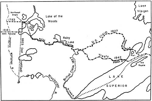
Simplied map showing 1827-42 dispute over boundary west of Lake Superior, and three stages of boundary-making beyond the northwest angle of the Lake of the Woods.
From the book Thrust and Counterthrust by H. George Classen, Academic Press Canada.
The Boundary Commission chapters are among the most interesting of the book. Indeed, they constitute a story previously almost entirely untold, of the ten-year effort to explore and survey the Great Lakes and the several canoe routes from Lake Superior to Lake of the Woods This is an epic saga of hardship and struggle, of engineering and diplomacy of achievement and failure. John Ogilvy a Montreal fur trader, was the British Commissioner who died of fever in the swamps of the Detroit River, and was succeeded by Thomas Barclay, the son of a New York Loyalist the American Commissioner was General Peter B. Porter later Secretary of War. Others of interest who served the Commissions were David Thompson, who at age 46 started a new ten-year career as Surveyor Lieutenant George W. Whistler, the father of the painter also a Surveyor; Major Joseph Delafield. United States Agent; and Dr. John J. Bigsby Secretary and Physician. Lass tells the story of the expeditions that set out each spring from 1816 to 1827. The placement of the line in every channel or narrow passage or waterfall was the result of extensive exploration, survey, mapping, debate, argument, tradeoff, and, possibly, compromise. The Commissioners and their Agents and staffs tended to be over-scrupulous in protecting what were perceived as their country’s interests. with the almost inevitable result that a basic distrust eventually characterized the relationships. In the end, after Barclay claimed the St. Louis River (near the present city of Duluth) as the boundary intended in 1783. and Porter countered with a claim for the Kaministikwia (near Thunder Bay) the Commission failed to agree about the Lake Superior-Lake of the Woods boundary. It was left to Lord Ashburton (in touch with Barclay) and Daniel Webster (advised by Delafield and others) in 1842 to take up the maps and reports produced by the Commissions. Lass, for the first time, gives us a detailed analysis of the process through which these two statesmen agreed on the Pigeon River as the border intended in the Treaty of 1783. Even this settlement did not ease the tasks of marking the actual frontier. In 1872 the Canadian Commissioner, Donald R. Cameron, wanted to eliminate the Northwest Angle as United States territory and in 1896 Duluth Congressman Charles A. Towne wanted the United States to obtain control of Hunters Island. Such initiatives were met by stony refusals by both governments to reopen those agreements which had been so painfully reached.
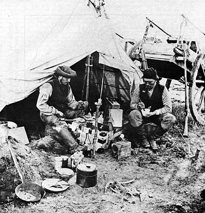
Boundary Commission photographers, 1872-73.
Source: Archives of Manitoba
Lass’s book will be the standard work on the Lake Superior to Red River boundary, but it reaches beyond those limits defined in the title. In order to make any sense out of the border, Lass has gone a long way towards writing a good general survey of Canadian-American boundary issues. The book is based on an extensive use of published and manuscript materials, and it is well illustrated with photographs and maps, including reproductions of important historic maps. Lass has written an excellent scholarly book.
Page revised: 1 January 2011